Stonewall County, Texas facts for kids
Quick facts for kids
Stonewall County
|
|
|---|---|

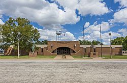
Stonewall County Courthouse in Aspermont
|
|

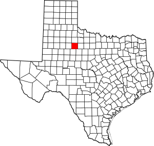
Location within the U.S. state of Texas
|
|
 Texas's location within the U.S. |
|
| Country | |
| State | |
| Founded | 1888 |
| Named for | Stonewall Jackson |
| Seat | Aspermont |
| Largest town | Aspermont |
| Area | |
| • Total | 920 sq mi (2,400 km2) |
| • Land | 916 sq mi (2,370 km2) |
| • Water | 3.9 sq mi (10 km2) 0.4% |
| Population
(2020)
|
|
| • Total | 1,245 |
| • Density | 1.353/sq mi (0.5225/km2) |
| Time zone | UTC−6 (Central) |
| • Summer (DST) | UTC−5 (CDT) |
| Congressional district | 19th |
Stonewall County is a county located in the U.S. state of Texas. As of the 2020 census, its population was 1,245. Its county seat is Aspermont. The county was created in 1876 and organized in 1888. It is named for Stonewall Jackson, a general of the Confederate States Army.
Contents
History
Stonewall County was formed in 1876 from the Young Territory. It was initially attached to Young County, Throckmorton County, and then Jones County, before finally becoming fully organized in 1889.
Geography
According to the U.S. Census Bureau, the county has a total area of 920 square miles (2,400 km2), of which 916 square miles (2,370 km2) are land and 3.9 square miles (10 km2) (0.4%) are covered by water.
Geographic features
- Double Mountain (county high point and most topographically prominent point for almost 160 miles (260 km)
- The Brazos River begins in Stonewall County at the confluence of the Double Mountain Fork and Salt Fork Brazos River, about 3 miles (4.8 km) west of Jud, Texas, now a ghost town.
- Kiowa Peak 3 mi (4.8 km) to the west of the Brazos River
Adjacent counties
- King County (north)
- Haskell County (east)
- Jones County (southeast)
- Fisher County (south)
- Kent County (west)
Demographics
| Historical population | |||
|---|---|---|---|
| Census | Pop. | %± | |
| 1880 | 104 | — | |
| 1890 | 1,024 | 884.6% | |
| 1900 | 2,183 | 113.2% | |
| 1910 | 5,320 | 143.7% | |
| 1920 | 4,086 | −23.2% | |
| 1930 | 5,667 | 38.7% | |
| 1940 | 5,589 | −1.4% | |
| 1950 | 3,679 | −34.2% | |
| 1960 | 3,017 | −18.0% | |
| 1970 | 2,397 | −20.6% | |
| 1980 | 2,406 | 0.4% | |
| 1990 | 2,013 | −16.3% | |
| 2000 | 1,693 | −15.9% | |
| 2010 | 1,490 | −12.0% | |
| 2020 | 1,245 | −16.4% | |
| U.S. Decennial Census 1850–2010 2010 2020 |
|||
| Race / Ethnicity (NH = Non-Hispanic) | Pop 2010 | Pop 2020 | % 2010 | % 2020 |
|---|---|---|---|---|
| White alone (NH) | 1,206 | 958 | 80.94% | 76.95% |
| Black or African American alone (NH) | 38 | 18 | 2.55% | 1.45% |
| Native American or Alaska Native alone (NH) | 4 | 3 | 0.27% | 0.24% |
| Asian alone (NH) | 14 | 5 | 0.94% | 0.40% |
| Pacific Islander alone (NH) | 0 | 0 | 0.00% | 0.00% |
| Other race alone (NH) | 0 | 2 | 0.00% | 0.16% |
| Mixed race or Multiracial (NH) | 19 | 33 | 1.28% | 2.65% |
| Hispanic or Latino (any race) | 209 | 226 | 14.03% | 18.15% |
| Total | 1,490 | 1,245 | 100.00% | 100.00% |
As of the census of 2010, 1,490 people, 642 households, and 426 families resided in the county. The population density was 2.0 people per square mile (0.77 people/km2). The 928 housing units averaged 1 unit per square mile (0.39 units/km2). The racial makeup of the county was 87.7% White, 2.6% Black or African American, 0.5% Native American, 0.9% Asian, 6.3% from other races, and 1.9% from two or more races. About 14.0% of the population was Hispanic or Latino of any race.
Of the 642 households, 24% had children under the age of 18 living with them, 53% were married couples living together, 10.1% had a female householder with no husband present, and 33.6% were not families; 15.7% had someone living alone who was 65 years of age or older. The average household size was 2.28 and the average family size was 2.83.
In the county, the population was distributed as 22.80% under the age of 18, 6.20% from 18 to 24, 22.60% from 25 to 44, 24.50% from 45 to 64, and 24.00% who were 65 years of age or older. The median age was 44 years. For every 100 females, there were 90.00 males. For every 100 females aged 18 and over, there were 91.10 males.
The median income for a household in the county was $27,935, and for a family was $35,571. Males had a median income of $27,083 versus $15,000 for females. The per capita income for the county was $16,094. About 14.80% of families and 19.30% of the population were below the poverty line, including 31.50% of those under age 18 and 14.50% of those age 65 or over.
Communities
Town
- Aspermont (county seat)
Unincorporated communities
Ghost town
Transportation
Major highways
Air
The county is served by Stonewall County Airport, a public airport located in Aspermont, 1 nautical mile (1.9 km) northeast of the central business district.
Education
School districts include:
- Aspermont Independent School District
- Hamlin Independent School District
- Haskell Consolidated Independent School District
- Rotan Independent School District
- Rule Independent School District
The Texas Legislature designated the county as being in the Western Texas College District.
See also
 In Spanish: Condado de Stonewall para niños

