Stollberg Rural District facts for kids
Quick facts for kids
Stollberg
|
||
|---|---|---|
|
||
 |
||
| Country | ||
| State | Saxony | |
| Adm. region | Chemnitz | |
| Capital | Stollberg | |
| Area | ||
| • Total | 266.49 km2 (102.89 sq mi) | |
| Population
(2001)
|
||
| • Total | 93,041 | |
| • Density | 349.135/km2 (904.256/sq mi) | |
| Time zone | UTC+1 (CET) | |
| • Summer (DST) | UTC+2 (CEST) | |
| Vehicle registration | STL | |
| Website | landkreis-stollberg.de | |
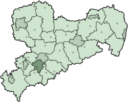
Stollberg Rural District was a district in the Free State of Saxony, Germany. Chemnitzer Land. It ended in 2008.
History
It was first created in 1910. In 1950 the district was dissolved. In 1952 it was set up again. In the big reform of 1994 the Stollberg Rural District got bigger, because some smaller towns and villages from the city of Zwönitz and districts of Chemnitz and Aue, were transferred to Stollberg.
Stollberg Rural District is on the northwestern slope of the Erzgebirge Mountains.
Partnerships
Since 1990 the district has a partnership with the district Fürth in Bavaria.
Coat of arms
 |
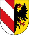
The left half of the coat of arms show the symbol of the Counts of Schönberg - the county of Schönberg covered most of the area of the district. To the right is the imperial eagle symbolizing the Pleissenland, an imperial estate. The colours of the right side are also identical with those of Meißen, as another part of the district historically belonged to the County of Meissen. |
Towns and municipalities
| Cities | Municipalities |
|---|---|
|
|

All content from Kiddle encyclopedia articles (including the article images and facts) can be freely used under Attribution-ShareAlike license, unless stated otherwise. Cite this article:
Stollberg Rural District Facts for Kids. Kiddle Encyclopedia.
