Stateline, Idaho facts for kids
Quick facts for kids
Stateline
|
|
|---|---|

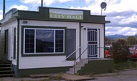
Former City Hall
|
|

Location of Stateline in Kootenai County, Idaho
|
|
| Country | United States |
| State | Idaho |
| County | Kootenai |
| Incorporated | 1947 |
| Area | |
| • Total | 0.11 sq mi (0.29 km2) |
| • Land | 0.11 sq mi (0.29 km2) |
| • Water | 0.00 sq mi (0.00 km2) |
| Elevation | 2,106 ft (642 m) |
| Population
(2020)
|
|
| • Total | 39 |
| • Estimate
(2022)
|
39 |
| • Density | 354.10/sq mi (136.70/km2) |
| Time zone | UTC–8 (Pacific (PST)) |
| • Summer (DST) | UTC–7 (PDT) |
| ZIP Code |
83854
|
| Area code(s) | 208 and 986 |
| FIPS code | 16-77050 |
| GNIS feature ID | 2411974 |
Stateline, officially the City of State Line, and historically known as State Line Village, is a city in Kootenai County, Idaho, United States, and is both the easternmost suburb of Spokane, Washington and the westernmost suburb of Coeur d'Alene, Idaho. The population was 39 at the 2020 census. The city is known for the adult services it provides which attract business from nearby Spokane and Coeur d'Alene. The unincorporated community of Spokane Bridge, Washington is located across the Spokane River to the southwest.
Contents
History
Stateline, located along the former route of U.S. Route 10, was incorporated in 1947 so that it could sell liquor and have slot machines. It had a population of 137 at the time.
Geography
Stateline is located at 47°42′18″N 117°2′17″W / 47.70500°N 117.03806°W (47.705131, -117.037933).
According to the United States Census Bureau, the city has a total area of 0.10 square miles (0.26 km2), all land.
Demographics
| Historical population | |||
|---|---|---|---|
| Census | Pop. | %± | |
| 1950 | 52 | — | |
| 1960 | 33 | −36.5% | |
| 1970 | 22 | −33.3% | |
| 1980 | 26 | 18.2% | |
| 1990 | 26 | 0.0% | |
| 2000 | 28 | 7.7% | |
| 2010 | 38 | 35.7% | |
| 2020 | 39 | 2.6% | |
| 2022 (est.) | 39 | 2.6% | |
| U.S. Decennial Census 2020 Census |
|||
2010 census
As of the census of 2010, there were 38 people in 20 households, including 9 families, in the city. The population density was 380.0 inhabitants per square mile (146.7/km2). There were 21 housing units at an average density of 210.0 per square mile (81.1/km2). The racial makup of the city was 100.0% White.
Of the 20 households 25.0% had children under the age of 18 living with them, 20.0% were married couples living together, 15.0% had a female householder with no husband present, 10.0% had a male householder with no wife present, and 55.0% were non-families. 40.0% of households were one person and 20% were one person aged 65 or older. The average household size was 1.90 and the average family size was 2.56.
The median age was 41.5 years. 23.7% of residents were under the age of 18; 0.0% were between the ages of 18 and 24; 34.2% were from 25 to 44; 15.8% were from 45 to 64; and 26.3% were 65 or older. The gender makeup of the city was 55.3% male and 44.7% female.
See also
 In Spanish: State Line (Idaho) para niños

