State Highway 95 (New Zealand) facts for kids
Quick facts for kids
State Highway 95 |
||||
|---|---|---|---|---|
| Lua error in Module:Infobox_road/map at line 15: attempt to index field 'wikibase' (a nil value). | ||||
| Route information | ||||
| Maintained by NZ Transport Agency | ||||
| Length | 20.5 km (12.7 mi) | |||
| Tourist routes |
Southern Scenic Route |
|||
| Major junctions | ||||
| North end | ||||
| South end | Manapouri | |||
| Highway system | ||||
|
||||
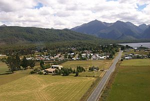
State Highway 95 is a New Zealand state highway connecting the town of Manapouri with Te Anau at State Highway 94. The highway is a major tourist road and skirts the eastern border of Fiordland National Park between Lake Te Anau and Lake Manapouri. Despite affording views of the scenic mountain ranges of Fiordland, the road itself is largely flat and passes through agricultural land. The entire length of the road lies on the Southern Scenic Route between Queenstown and Dunedin via Invercargill.

All content from Kiddle encyclopedia articles (including the article images and facts) can be freely used under Attribution-ShareAlike license, unless stated otherwise. Cite this article:
State Highway 95 (New Zealand) Facts for Kids. Kiddle Encyclopedia.

