St. Charles County, Missouri facts for kids
Quick facts for kids
St. Charles County
|
||
|---|---|---|

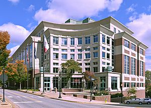
St. Charles County Courthouse in St. Charles
|
||
|
||

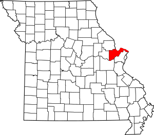
Location within the U.S. state of Missouri
|
||
 Missouri's location within the U.S. |
||
| Country | ||
| State | ||
| Founded | October 1, 1812 | |
| Named for | Charles Borromeo | |
| Seat | St. Charles | |
| Largest city | O'Fallon | |
| Area | ||
| • Total | 593 sq mi (1,540 km2) | |
| • Land | 560 sq mi (1,500 km2) | |
| • Water | 32 sq mi (80 km2) 5.4% | |
| Population
(2020)
|
||
| • Total | 405,262 | |
| • Density | 683.4/sq mi (263.87/km2) | |
| Time zone | UTC−6 (Central) | |
| • Summer (DST) | UTC−5 (CDT) | |
| Congressional districts | 2nd, 3rd | |
St. Charles County is located in the central eastern part of the U.S. state of Missouri. As of the 2020 census, the population was 405,262, making it Missouri's third-most populous county. Its county seat is St. Charles. The county was organized October 1, 1812, and named for Saint Charles Borromeo, an Italian cardinal.
St. Charles County is part of the St. Louis, MO-IL Metropolitan Statistical Area and contains many of the city's northwestern suburbs. The wealthiest county in Missouri, St. Charles County is one of the nation's fastest-growing counties.
St. Charles County includes a part of the Augusta AVA, an area of vineyards and wineries designated by the federal government in 1980 as the first American Viticultural Area. The county's rural outer edge along the south-facing bluffs above the Missouri River, is also part of the broader Missouri Rhineland.
History
The County of St. Charles was originally called the District of St. Charles and had no definite limits until 1816 to 1818 when neighboring counties were formed. The borders of St. Charles are the same today as they were in 1818.
Geography
According to the U.S. Census Bureau, the county has a total area of 593 square miles (1,540 km2), of which 560 square miles (1,500 km2) is land and 32 square miles (83 km2) (5.4%) is water.
The highest elevation is 901 feet (275 m) northwest of Augusta near Femme Osage Creek headwaters.
Adjacent counties
- Lincoln County (northwest)
- Calhoun County, Illinois (north)
- Jersey County, Illinois (northeast)
- Madison County, Illinois (east)
- St. Louis County (southeast)
- Franklin County (south)
- Warren County (west)
Major highways
 I-64 – Major freeway in the western portion of the county. Originally U.S. Route 40, the highway was upgraded to Interstate standards in the late 2000s. The highway was re-signed as Interstate 64 from the Daniel Boone Bridge to Interstate 70 in Wentzville in 2009.
 I-70 – The major east–west thoroughfare in the county. It is mostly a six-lane freeway in the county, but there are sections in St. Charles and St. Peters where the Interstate widens to 11 lanes of traffic.
 Interstate 70 Business
 US-40
US-40 US-61
US-61 US-67
US-67 Rte-79
 Rte-94
 Rte-364 – A freeway in the southern and central portions of the county that begins at Interstate 270 in western St. Louis County and ends at Interstate 64 in Lake St. Louis.
 Rte-370 – A six-lane freeway that connects Interstate 70 in St. Charles County and Interstate 270 in St. Louis County.
National protected area
Climate
|
||||||||||||||||||||||||||||||||||||||||||||||||||||||||||||||||||||||||||||||||||||||||||||||||
Demographics
| Historical population | |||
|---|---|---|---|
| Census | Pop. | %± | |
| 1810 | 3,505 | — | |
| 1820 | 3,970 | 13.3% | |
| 1830 | 4,320 | 8.8% | |
| 1840 | 7,911 | 83.1% | |
| 1850 | 11,454 | 44.8% | |
| 1860 | 16,523 | 44.3% | |
| 1870 | 21,304 | 28.9% | |
| 1880 | 23,065 | 8.3% | |
| 1890 | 22,977 | −0.4% | |
| 1900 | 24,474 | 6.5% | |
| 1910 | 24,695 | 0.9% | |
| 1920 | 22,828 | −7.6% | |
| 1930 | 24,354 | 6.7% | |
| 1940 | 25,562 | 5.0% | |
| 1950 | 29,834 | 16.7% | |
| 1960 | 52,970 | 77.5% | |
| 1970 | 92,954 | 75.5% | |
| 1980 | 144,107 | 55.0% | |
| 1990 | 212,907 | 47.7% | |
| 2000 | 283,883 | 33.3% | |
| 2010 | 360,485 | 27.0% | |
| 2020 | 405,262 | 12.4% | |
| U.S. Decennial Census 1790–1960 1900–1990 1990–2000 2010–2020 |
|||
| Race / Ethnicity (NH = Non-Hispanic) | Pop 2000 | Pop 2010 | Pop 2020 | % 2000 | % 2010 | % 2020 |
|---|---|---|---|---|---|---|
| White alone (NH) | 266,158 | 321,078 | 335,879 | 93.76% | 89.07% | 82.88% |
| Black or African American alone (NH) | 7,573 | 14,827 | 20,672 | 2.67% | 4.11% | 5.10% |
| Native American or Alaska Native alone (NH) | 596 | 692 | 623 | 0.21% | 0.19% | 0.15% |
| Asian alone (NH) | 2,397 | 7,789 | 11,068 | 0.84% | 2.16% | 2.73% |
| Pacific Islander alone (NH) | 61 | 153 | 199 | 0.02% | 0.04% | 0.05% |
| Other race alone (NH) | 224 | 427 | 1,377 | 0.08% | 0.12% | 0.34% |
| Mixed race or Multiracial (NH) | 2,698 | 5,536 | 19,433 | 0.95% | 1.54% | 4.80% |
| Hispanic or Latino (any race) | 4,176 | 9,983 | 16,011 | 1.47% | 2.77% | 3.95% |
| Total | 283,883 | 360,485 | 405,262 | 100.00% | 100.00% | 100.00% |
2020 census
As of 2020, there were 405,262 people and 150,668 households residing in the county. The population density was 643 inhabitants per square mile (248/km2). There were 161,144 housing units. The racial makeup of the county was 83.8% White, 5.2% African American, 0.1% Native American, 2.8% Asian, 0.1% Pacific Islander, and 6.5% from two or more races. Hispanic or Latino made up 4.0% of the population.
There were 101,663 households, out of which 40.50% had children under the age of 18 living with them, 63.20% were married couples living together, 9.20% have a woman whose husband does not live with her, and 24.20% were non-families. 19.40% of all households were made up of individuals, and 5.90% had someone living alone who was 65 years of age or older. The average household size was 2.76 and the average family size was 3.18.
In the county, the population was spread out in age, with 29.00% under the age of 18, 8.20% from 18 to 24, 32.60% from 25 to 44, 21.60% from 45 to 64, and 8.80% who were 65 years of age or older. The median age was 34 years. For every 100 females there were 97.10 males. For every 100 females age 18 and over, there were 94.10 males.
The median income for a household in the county was $71,458, and the median income for a family was $64,415. Males had a median income of $44,528 versus $29,405 for females. The per capita income for the county was $23,592. 4.00% of the population and 2.80% of families were below the poverty line. Out of the total people living in poverty, 4.90% are under the age of 18 and 5.10% are 65 or older.
St. Charles County has had one of the fastest-growing populations in the state for many decades, with 55% growth in the 1970s, 48% in the 1980s, 33% in the 1990s, and another 27% in the 2000s. The county sits at a cross-section of industry, as well as extensive retail and some agriculture. With the Missouri River on the south and east and the Mississippi River on the north, the county is bisected east to west by Interstate 70. After St. Charles Airport closed in 2010, the county has one remaining small airport, St. Charles County Smartt Airport. Two ferries cross the Mississippi River from St. Charles County.
Education
Public schools
School districts include:
- Fort Zumwalt R-II School District
- Francis Howell R-III School District
- Orchard Farm R-V School District
- St. Charles R-VI School District
- Washington School District
- Wentzville R-IV School District
High schools (all grades 9–12):
- Fort Zumwalt District
-
- Fort Zumwalt East High School – St. Peters
- Fort Zumwalt North High School – O'Fallon
- Fort Zumwalt South High School – St. Peters
- Fort Zumwalt West High School – O'Fallon
- Francis Howell District
-
- Francis Howell Central High School – Cottleville
- Francis Howell North High School – St. Peters
- Francis Howell High School – Weldon Spring Heights
- Orchard Farm District
-
- Orchard Farm High School – St. Charles
- St. Charles District
-
- St. Charles High School – St. Charles
- St. Charles West High School – St. Charles
- Wentzville District
-
- Liberty High School – Lake St. Louis
- Emil E. Holt High School – Wentzville
- Timberland High School – Wentzville
Private schools
- Academy of the Sacred Heart – St. Charles – (PK-08) – Roman Catholic
- All Saints School – St. Peters – (K-08) – Roman Catholic
- Assumption Catholic Grade School – O'Fallon – (K-08) – Roman Catholic
- Christian High School– O'Fallon and St. Peters– (PK-12) – Non-denominational Christian
- Duchesne High School– St. Charles– (09-12)– Roman Catholic
- First Baptist Christian Academy – O'Fallon – (PK-07) – Non-denominational Christian
- Foristell Baptist Academy – Foristell – (K-09) – Baptist
- Hope Montessori Academy – Lake St. Louis – (PK-K) – Nonsectarian
- Immaculate Conception Catholic School – Dardenne Prairie – (K-08) – Roman Catholic
- Immanuel Lutheran School – St. Charles – (PK-08) – Lutheran
- Immanuel Lutheran School – Wentzville – (PK-08) – Lutheran
- Liberty Classical School – O'Fallon – (07-12) – Non-denominational Christian
- Lutheran High School of St. Charles County – St. Peters – (09-12) – Lutheran
- Messiah Lutheran School – Weldon Spring – (PK-08) – Lutheran
- Mid Rivers Seventh-day Adventist School – St. Peters – (03-08) – Seventh-day Adventist
- St. Charles Borromeo – St. Charles – (K-08) – Roman Catholic
- St. Cletus School – St. Charles – (K-08) – Roman Catholic
- St. Dominic High School – O'Fallon – (09-12) – Roman Catholic
- St. Elizabeth St. Robert Regional School – St. Charles – (PK-08) – Roman Catholic
- St. Joseph School – Cottleville – (K-08) – Roman Catholic
- St. Joseph School – Wentzville – (PK-08) – Roman Catholic
- St. Patrick Elementary School – Wentzville – (K-08) – Roman Catholic
- St. Paul Elementary School – St. Paul – (PK-08) – Roman Catholic
- St. Peter Catholic School – St. Charles – (PK-08) – Roman Catholic
- St. Theodore School – Wentzville – (K-08) – Roman Catholic
- Sts. Joachim & Ann School – St. Charles – (PK-08) – Roman Catholic
- Trinity Lutheran School – St. Charles – (01-08) – Lutheran
- Willott Road Christian Academy – St. Peters – (NS-09) – Baptist
- Zion Lutheran School – St. Charles – (PK-08) – Lutheran
Alternative schools
- Boonslick State School – St. Peters – Special Education
- Fort Zumwalt Hope High School – O'Fallon – Other/Alternative School – (09-12)
- Francis Howell Union High School – St. Charles – Other/Alternative School – (09-12)
- Heritage Landing – St. Peters – Other/Alternative School – (06-12)
- The Lead School – O'Fallon – Other/Alternative School – (K-12)
- Lewis & Clark Career Center – St. Charles – Vocational/Technical School – (09-12)
- Quest Day Treatment Center – St. Charles – Other/Alternative School – (06-12)
- Success Campus – St. Charles – Other/Alternative School – (09-12)
Higher education
- Lindenwood University – St. Charles
- St. Charles Community College – Cottleville
Public libraries
- St. Charles City-County Library District
Communities
Cities
Villages
Census-designated place
Other unincorporated places
Islands
- Apple Island
- Dresser Island
- Ellis Island
- Howell Island
- Two Branch Island
Subregions
Westplex
Westplex is an area within St. Charles County in east-central Missouri to the west of St. Louis County.
The Westplex is part of St. Charles County that used to be called "The Golden Triangle". The "triangle" was formed by I-70 to the north, Missouri Route 94 to the southeast, and I-64 to the southwest. Since almost all of the growth in St. Charles County was within this triangle it was dubbed the "Golden" area of St. Charles county, hence, Golden Triangle. Today the Westplex is made up of St. Charles, St. Peters, Weldon Spring, Cottleville, Dardenne Prairie, O'Fallon, Lake St. Louis, and Wentzville.
See also
 In Spanish: Condado de Saint Charles para niños


