St. Anne, Illinois facts for kids
Quick facts for kids
St. Anne, Illinois
|
|
|---|---|

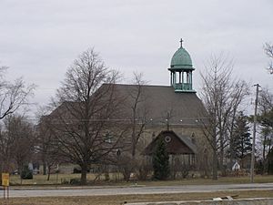
Shrine and parish church of St. Anne
|
|
| Nickname(s):
St. Anners
|
|

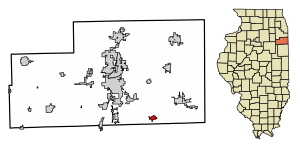
Location of St. Anne in Kankakee County, Illinois
|
|

Location of Illinois in the United States
|
|
| Country | United States |
| State | Illinois |
| County | Kankakee |
| Township | St. Anne |
| Area | |
| • Total | 0.86 sq mi (2.23 km2) |
| • Land | 0.83 sq mi (2.15 km2) |
| • Water | 0.03 sq mi (0.08 km2) |
| Elevation | 664 ft (202 m) |
| Population
(2020)
|
|
| • Total | 1,161 |
| • Density | 1,398.80/sq mi (539.81/km2) |
| Time zone | UTC-6 (CST) |
| • Summer (DST) | UTC-5 (CDT) |
| ZIP code |
60964
|
| Area codes | 815 & 779 |
| FIPS code | 17-66638 |
| GNIS feature ID | 2399157 |
| Wikimedia Commons | St. Anne, Illinois |
St. Anne (sometimes spelled Saint Anne) is a village in Kankakee County, Illinois, United States. The population was 1,161 at the 2020 census. It is part of the Kankakee–Bourbonnais–Bradley Metropolitan Statistical Area. It was founded in 1851 by Charles Chiniquy, a French-Canadian Catholic priest and friend of the 16th U.S. President Abraham Lincoln who was excommunicated by the Catholic Church in 1856. He later converted to Protestant Christianity, becoming a Presbyterian Evangelical minister and a well-known temperance activist in Canada and the United States.
Geography
St. Anne is located in southeastern Kankakee County. Illinois Route 1 passes through the west side of the village. It is 13 miles (21 km) southeast of Kankakee, the county seat, and 18 miles (29 km) north of Watseka.
According to the 2010 census, St. Anne has a total area of 0.793 square miles (2.05 km2), of which 0.77 square miles (1.99 km2) (or 97.1%) is land and 0.023 square miles (0.06 km2) (or 2.9%) is water.
Demographics
| Historical population | |||
|---|---|---|---|
| Census | Pop. | %± | |
| 1880 | 412 | — | |
| 1890 | 718 | 74.3% | |
| 1900 | 1,000 | 39.3% | |
| 1910 | 1,065 | 6.5% | |
| 1920 | 1,067 | 0.2% | |
| 1930 | 1,078 | 1.0% | |
| 1940 | 1,131 | 4.9% | |
| 1950 | 1,403 | 24.0% | |
| 1960 | 1,378 | −1.8% | |
| 1970 | 1,271 | −7.8% | |
| 1980 | 1,421 | 11.8% | |
| 1990 | 1,153 | −18.9% | |
| 2000 | 1,212 | 5.1% | |
| 2010 | 1,257 | 3.7% | |
| 2020 | 1,161 | −7.6% | |
| U.S. Decennial Census | |||
As of the census of 2000, there were 1,212 people, 464 households, and 330 families residing in the village. The population density was 2,385.3 inhabitants per square mile (921.0/km2). There were 486 housing units at an average density of 956.5 per square mile (369.3/km2). The racial makeup of the village was 89.85% White, 0.83% African American, 0.41% Native American, 0.08% Asian, 0.08% Pacific Islander, 6.60% from other races, and 2.15% from two or more races. Hispanic or Latino of any race were 10.48% of the population.
There were 464 households, out of which 36.9% had children under the age of 18 living with them, 55.0% were married couples living together, 11.2% had a female householder with no husband present, and 28.7% were non-families. 23.3% of all households were made up of individuals, and 11.2% had someone living alone who was 65 years of age or older. The average household size was 2.61 and the average family size was 3.08.
In the village, the population was spread out, with 30.0% under the age of 18, 8.3% from 18 to 24, 28.1% from 25 to 44, 20.2% from 45 to 64, and 13.5% who were 65 years of age or older. The median age was 34 years. For every 100 females, there were 96.4 males. For every 100 females age 18 and over, there were 89.5 males.
The median income for a household in the village was $39,306, and the median income for a family was $41,250. Males had a median income of $32,000 versus $25,086 for females. The per capita income for the village was $16,702. About 11.7% of families and 13.4% of the population were below the poverty line, including 18.2% of those under age 18 and 6.4% of those age 65 or over.
Education
St. Anne Community High School is the sole high school within the region, and an elementary school also named for the town exists across the street from the high school. The closest institution of higher education to St. Anne is Kankakee Community College.
Transportation
Illinois Route 1, part of the Western route of the historic Dixie Highway, runs north and south in St. Anne. Interstate 57 is the closest interstate highway to St Anne. The town is also located about 5 miles away from the banks of the Iroquois River, which itself connects to the rest of the world through the Mississippi, Illinois, and Kankakee Rivers.
St. Anne has no passenger railroad services of its own, however, Union Pacific Railroad owns freight rail tracks which pass through the city. St. Anne formerly was served by passenger rail, then operated by the New York Central Railroad, the Missouri Pacific Railroad and the Chicago and Eastern Illinois Railroad.
Air transport is limited in St. Anne, with the closest airport being the general aviation-exclusive Kankakee Airport. Commercial air service's closest links to St. Anne are through the two major Chicago airports, with Midway being slightly closer to St. Anne than O'Hare.
Notable people
- Jack Sikma (born 1955), seven-time NBA All-Star and Hall of Fame center for 1979 NBA champion Seattle SuperSonics; attended St. Anne High School
- Joseph M. Pallissard (1886–1960), one of the Early Birds of Aviation. He was a childhood resident of St. Anne.
- Florence Price (1887–1953), classical composer, pianist, organist and music teacher. Price maintained a seasonal residence in St. Anne. In 2009, a couple who were renovating an abandoned house on the outskirts of St. Anne discovered that it contained a trove of her manuscripts including dozens of pieces that had been thought lost.
See also
 In Spanish: St. Anne para niños

