Spencer County, Indiana facts for kids
Quick facts for kids
Spencer County
|
|
|---|---|

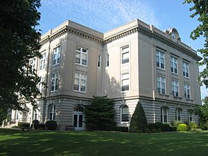
Spencer County Courthouse in Rockport, Indiana
|
|

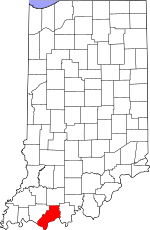
Location within the U.S. state of Indiana
|
|
 Indiana's location within the U.S. |
|
| Country | |
| State | |
| Founded | January 10, 1818 |
| Named for | Spier Spencer |
| Seat | Rockport |
| Largest town | Santa Claus |
| Area | |
| • Total | 401.43 sq mi (1,039.7 km2) |
| • Land | 396.74 sq mi (1,027.6 km2) |
| • Water | 4.68 sq mi (12.1 km2) |
| Population
(2020)
|
|
| • Total | 19,810 |
| • Density | 49.9/sq mi (19.3/km2) |
| Time zone | UTC−6 (Central) |
| • Summer (DST) | UTC−5 (CDT) |
| Congressional district | 8th |
| Indiana county number 74 | |
Spencer County is a county located in the U.S. state of Indiana. As of the 2020 census, the population was 19,810. The county seat is Rockport. Despite not being in the Owensboro Metropolitan Area, the entire riverfront of the city of Owensboro, Kentucky borders the southern tip of the county.
Contents
History
Spencer County was formed in 1818 from parts of Warrick County and Perry County. It was named for Captain Spier Spencer, killed at the Battle of Tippecanoe in 1811.
The Spencer County courthouse was built in 1921. It is the fifth courthouse to serve the county.
Abraham Lincoln lived in Spencer County from 1816 to 1830, between the ages seven and twenty-one. His family moved to Illinois in 1830. The Lincoln Boyhood National Memorial is located at the site of the Lincoln family farm.
Other attractions in the county include the town of Santa Claus and Holiday World & Splashin' Safari and also Santa's Candy Castle
Saint Meinrad Archabbey is located at the northeastern corner of Spencer County.
Geography
According to the 2010 census, the county has a total area of 401.43 square miles (1,039.7 km2), of which 396.74 square miles (1,027.6 km2) (or 98.83%) is land and 4.68 square miles (12.1 km2) (or 1.17%) is water.
Cities and towns
ZIP Codes are in parentheses.
- Chrisney (47611)
- Dale (47523)
- Gentryville (47537)
- Grandview (47615)
- Richland (47634)
- Rockport (47635)
- Santa Claus (47579)
Census-designated place
- St. Meinrad (47577)
Other unincorporated places
- Africa
- Bloomfield
- Buffaloville
- Centerville
- Clay City
- Enterprise
- Eureka
- Evanston (47531)
- Fulda (47531)
- Hatfield (47617)
- Huffman
- Kennedy
- Kercheval
- Lamar (47550)
- Liberal
- Lincoln City (47552)
- Mariah Hill (47556)
- Maxville
- Midway
- New Boston
- Newtonville
- Patronville
- Pigeon
- Pueblo
- Pyeattville
- Reo
- Ritchie
- Rock Hill
- Rockport Junction
- Sand Ridge
- Santa Fe
- Schley
- Silverdale
Townships
- Carter
- Clay
- Grass
- Hammond
- Harrison
- Huff
- Jackson
- Luce
- Ohio
Adjacent counties
- Dubois County, Indiana (north/EST border)
- Daviess County, Kentucky (south)
- Perry County, Indiana (east)
- Hancock County, Kentucky (southeast)
- Warrick County, Indiana (west)
Major highways
 Interstate 64
 U.S. Route 231
 Indiana State Road 62
 Indiana State Road 66
 Indiana State Road 68
 Indiana State Road 70
 Indiana State Road 161
 Indiana State Road 162
 Indiana State Road 245
 Indiana State Road 545
National protected area
Climate and weather
| Weather chart for Rockport, Indiana | |||||||||||||||||||||||||||||||||||||||||||||||
|---|---|---|---|---|---|---|---|---|---|---|---|---|---|---|---|---|---|---|---|---|---|---|---|---|---|---|---|---|---|---|---|---|---|---|---|---|---|---|---|---|---|---|---|---|---|---|---|
| J | F | M | A | M | J | J | A | S | O | N | D | ||||||||||||||||||||||||||||||||||||
|
3.5
43
24
|
3.9
49
29
|
4.3
59
37
|
4.7
70
45
|
4.8
79
55
|
3.6
87
64
|
3.8
91
68
|
3.5
90
65
|
3.5
83
58
|
3
73
46
|
4.1
59
37
|
3.9
47
29
|
||||||||||||||||||||||||||||||||||||
| temperatures in °F precipitation totals in inches source: The Weather Channel |
|||||||||||||||||||||||||||||||||||||||||||||||
|
Metric conversion
|
|||||||||||||||||||||||||||||||||||||||||||||||
In recent years, average temperatures in Rockport have ranged from a low of 24 °F (−4 °C) in January to a high of 91 °F (33 °C) in July, although a record low of −23 °F (−31 °C) was recorded in January 1994 and a record high of 107 °F (42 °C) was recorded in June 1944. Average monthly precipitation ranged from 3.01 inches (76 mm) in October to 4.78 inches (121 mm) in May.
Demographics
| Historical population | |||
|---|---|---|---|
| Census | Pop. | %± | |
| 1820 | 1,882 | — | |
| 1830 | 3,196 | 69.8% | |
| 1840 | 6,305 | 97.3% | |
| 1850 | 8,616 | 36.7% | |
| 1860 | 14,556 | 68.9% | |
| 1870 | 17,998 | 23.6% | |
| 1880 | 22,122 | 22.9% | |
| 1890 | 22,060 | −0.3% | |
| 1900 | 22,407 | 1.6% | |
| 1910 | 20,676 | −7.7% | |
| 1920 | 18,400 | −11.0% | |
| 1930 | 16,713 | −9.2% | |
| 1940 | 16,211 | −3.0% | |
| 1950 | 16,174 | −0.2% | |
| 1960 | 16,074 | −0.6% | |
| 1970 | 17,134 | 6.6% | |
| 1980 | 19,361 | 13.0% | |
| 1990 | 19,490 | 0.7% | |
| 2000 | 20,391 | 4.6% | |
| 2010 | 20,952 | 2.8% | |
| 2020 | 19,810 | −5.5% | |
| 2023 (est.) | 19,910 | −5.0% | |
| U.S. Decennial Census 1790-1960 1900-1990 1990-2000 2010 |
|||
As of the 2010 United States census, there were 20,952 people, 8,082 households, and 5,907 families residing in the county. The population density was 52.8 inhabitants per square mile (20.4/km2). There were 8,872 housing units at an average density of 22.4 per square mile (8.6/km2). The racial makeup of the county was 96.9% White, 0.5% Black or African American, 0.3% Asian, 0.2% American Indian, 1.3% from other races, and 0.8% from two or more races. Those of Hispanic or Latino origin made up 2.5% of the population. In terms of ancestry, 47.0% were German, 16.4% were Irish, 12.6% were English, and 11.1% were American.
Of the 8,082 households, 33.5% had children under the age of 18 living with them, 60.8% were married couples living together, 8.1% had a female householder with no husband present, 26.9% were non-families, and 23.2% of all households were made up of individuals. The average household size was 2.55 and the average family size was 3.00. The median age was 41.9 years.
The median income for a household in the county was $47,697 and the median income for a family was $61,365. Males had a median income of $44,526 versus $30,466 for females. The per capita income for the county was $23,609. About 6.8% of families and 12.1% of the population were below the poverty line, including 18.0% of those under age 18 and 12.8% of those age 65 or over.
Education
It has two school districts, North Spencer County School Corporation and South Spencer County School Corporation.
Notable people
- H. Justin Davidson, sixth dean, Samuel Curtis Johnson Graduate School of Management at Cornell University
- Ken Dilger, former professional football player, Indianapolis Colts and Tampa Bay Buccaneers
- Del Harris, vice president, Texas Legends professional basketball team
- Florence Henderson, former singer and actress
- Roger Kaiser, former professional basketball player and coach
- Bill Peet, former children's author
- Thomas Gamble Pitcher, former Superintendent of the United States Military Academy
- Howard Schnellenberger, former professional and collegiate football coach, head coach, 1983 Miami Hurricanes national championship team
- Abraham Lincoln, 16th President of the United States
See also
 In Spanish: Condado de Spencer (Indiana) para niños

