South Jefferson, Roanoke, Virginia facts for kids
Quick facts for kids
South Jefferson
|
|
|---|---|

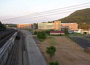
Carilion Clinic campus and the Norfolk Southern Railway
|
|
| Country | United States |
| State | Virginia |
| City | Roanoke |
| Elevation | 922 ft (281 m) |
| Time zone | UTC-5 (EST) |
| • Summer (DST) | UTC-4 (EDT) |
| ZIP Codes |
24016
|
| Area code(s) | 540 |
South Jefferson is a Roanoke, Virginia neighborhood located in southeast Roanoke, surrounded roughly by the Roanoke River to the south and east and the Roy L. Webber Expressway to the west, centered on South Jefferson Street. It borders the neighborhoods of Old Southwest on the west, Belmont and Downtown on the north, and Riverland/Walnut Hills via the Walnut Street Bridge on the east.
History
Historically serving various industrial activities, in May 2000 the South Jefferson area was identified as the South Jefferson Redevelopment Area by the City of Roanoke. The area is seeing significant redevelopment including the construction of the Carilion Clinic campus and the Virginia Tech Carilion School of Medicine.

All content from Kiddle encyclopedia articles (including the article images and facts) can be freely used under Attribution-ShareAlike license, unless stated otherwise. Cite this article:
South Jefferson, Roanoke, Virginia Facts for Kids. Kiddle Encyclopedia.
