South Greeley, Wyoming facts for kids
Quick facts for kids
South Greeley
|
|
|---|---|

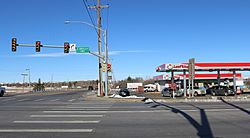
Looking west from the Intersection of South Greeley Highway (U.S. Route 85) and College Drive in South Greeley.
|
|

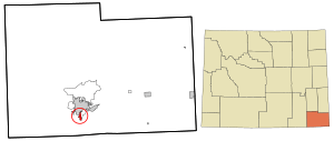
Location in Laramie County and the state of Wyoming.
|
|
| Country | United States |
| State | Wyoming |
| County | Laramie |
| Area | |
| • Total | 1.7 sq mi (4.4 km2) |
| • Land | 1.7 sq mi (4.4 km2) |
| • Water | 0 sq mi (0.0 km2) |
| Elevation | 6,047 ft (1,843 m) |
| Population
(2020)
|
|
| • Total | 4,733 |
| • Density | 2,790/sq mi (1,076/km2) |
| Time zone | UTC-7 (Mountain (MST)) |
| • Summer (DST) | UTC-6 (MDT) |
| Area code(s) | 307 |
| FIPS code | 56-71800 |
| GNIS feature ID | 1867671 |
South Greeley is a census-designated place (CDP) in Laramie County, Wyoming, United States. It is part of the Cheyenne, Wyoming Metropolitan Statistical Area. The population was 4,733 at the 2020 census. The population was 4,217 at the 2010 census.
Contents
Geography
South Greeley is located at 41°5′49″N 104°48′19″W / 41.09694°N 104.80528°W (41.097040, -104.805302).
According to the United States Census Bureau, the CDP has a total area of 1.7 square miles (4.4 km2), all land.
Despite its name, South Greeley is not adjacent to any other municipality with Greeley in its name. The nearest such place, Greeley, Colorado, lies approximately 50 miles to the south of South Greeley.
Demographics
At the 2020 Census, there were 4,733 people.
Education
Public education in the community of South Greeley is provided by Laramie County School District #1.
See also
 In Spanish: South Greeley (Wyoming) para niños


