Solothurn (canton) facts for kids
Quick facts for kids
Solothurn
|
||
|---|---|---|
|
||
 |
||
| Capital | Solothurn | |
| Subdivisions | 126 municipalities, 10 districts | |
| Area | ||
| • Total | 791 km2 (305 sq mi) | |
| Area rank | 16th | |
| Population
(2006)
|
||
| • Total | 251,657 | |
| • Rank | 12th | |
| • Density | 318.15/km2 (824.0/sq mi) | |
| Highest point | 1,445 m (4,741 ft) - Hasenmatt | |
| Joined | 1481 | |
| Abbreviation | SO | |
| Languages | German | |
| Website | SO.ch | |
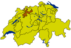
Solothurn is a canton of Switzerland. It can be found in the northwest of Switzerland. The capital is Solothurn.
Contents
Districts
There are 10 districts in Solothurn:
- Bucheggberg, Amtei Wasseramt-Bucheggberg
- Dorneck, Amtei Dorneck-Thierstein (unofficially Schwarzbubenland)
- Gäu, Amtei Thal-Gäu
- Gösgen, Amtei Olten-Gösgen (unofficially Niederamt)
- Lebern, Amtei Solothurn-Lebern
- Olten, Amtei Olten-Gösgen
- Solothurn, Amtei Solothurn-Lebern
- Thal, Amtei Thal-Gäu
- Thierstein, Amtei Dorneck-Thierstein
- Wasseramt, Amtei Wasseramt-Bucheggberg
Municipalities
The canton has 125 municipalities:
Images for kids
See also
 In Spanish: Cantón de Soleura para niños

All content from Kiddle encyclopedia articles (including the article images and facts) can be freely used under Attribution-ShareAlike license, unless stated otherwise. Cite this article:
Solothurn (canton) Facts for Kids. Kiddle Encyclopedia.


