Sidi Bel Abbès Province facts for kids
Quick facts for kids
Sidi Bel Abbès Province
ولاية سيدي بلعباس
|
|
|---|---|

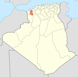
Map of Algeria highlighting Sidi Bel Abbès
|
|
| Country | |
| Capital | Sidi Bel Abbès |
| Area | |
| • Total | 9,150.63 km2 (3,533.08 sq mi) |
| Population
(2008)
|
|
| • Total | 603,369 |
| • Density | 65.93743/km2 (170.77715/sq mi) |
| Time zone | UTC+01 (CET) |
| Area Code | +213 (0) 48 |
| ISO 3166 code | DZ-22 |
| Districts | 15 |
| Municipalities | 52 |
Sidi Bel Abbès is one of the provinces of Algeria. The name is from the city of Sidi Bel Abbès. It is in the northwestern part of the country.
Divisions
The province has 15 districts and 52 communes or municipalities.
Districts
- Aïn El Berd
- Ben Badis
- Marhoum
- Mérine
- Mostefa Ben Brahim
- Moulay Slissen
- Ras El Ma
- Sfisef
- Sidi Ali Benyoub
- Sidi Ali Boussidi
- Sidi Bel Abbès
- Sidi Lahcène
- Télagh
- Ténira
- Téssala
See also
 In Spanish: Provincia de Sidi Bel Abbes para niños

All content from Kiddle encyclopedia articles (including the article images and facts) can be freely used under Attribution-ShareAlike license, unless stated otherwise. Cite this article:
Sidi Bel Abbès Province Facts for Kids. Kiddle Encyclopedia.
