Shenfield facts for kids
Quick facts for kids Shenfield |
|
|---|---|
| Village | |
 St Mary's Church, Shenfield |
|
| Area | 6.84 km2 (2.64 sq mi) |
| Population | 5,396 |
| • Density | 788.9/km2 |
| OS grid reference | TQ614950 |
| • London | 20.8 miles NNE |
| District |
|
| Shire county | |
| Region | |
| Country | England |
| Sovereign state | United Kingdom |
| Post town | BRENTWOOD |
| Postcode district | CM15 |
| Dialling code | 01277 |
| Police | Essex |
| Fire | Essex |
| Ambulance | East of England |
| EU Parliament | East of England |
| UK Parliament |
|
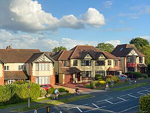
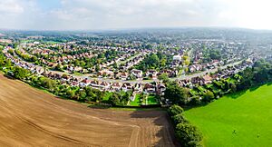
Shenfield is a suburb of Brentwood in the Borough of Brentwood, Essex, England. In 2020, it was estimated to have a population of 5,396.
Contents
History
The former village, by the church and Green Dragon pub, lies along the original Roman road (now the A1023) which linked London and Colchester.
Nathaniel Ward, a Puritan clergyman and author, was made minister of the Shenfield church in 1648 and held that office until his death in 1652.
In 1870–72, John Marius Wilson's Imperial Gazetteer of England and Wales described Shenfield like this:
SHENFIELD, a village and a parish in Billericay district, Essex. The village stands near the Eastern Counties railway, 1 mile NE of Brentwood; and dates from at least the time of Edward the Confessor. The parish comprises 2,397 acres. Post town, Brentwood. Rated property, £7,316. Pop. in 1851, 938; in 1861, 1,149 Houses, 229. The property is much subdivided. The manor of Fitzwalters was formerly held on the tenure of presenting gilt spurs at the king's coronation. Roman antiquities have been found. The living is a rectory in the diocese of Rochester. Value, £580.* Patron, Countess Cowper. The church is very ancient; was restored in 1863, and enlarged in 1867. National schools were built in 1865. Charities, £3.
Shenfield is a former civil parish; in 1931, it had a population of 3501. On 1 April 1934 the parish was abolished. Most of the area, including Shenfield, was added to the urban district of Brentwood, whilst a smaller area was added to Mountnessing.
Geography
The original village centre is located one mile (1.6 km) north-east of the centre of Brentwood. Apart from some small industrial areas and a modest but busy shopping area.
The parish church is dedicated to St Mary the Virgin and St Mary's primary school is located nearby.
The town of Hutton, to the east of Shenfield, is now largely part of the built-up area.
Sport and leisure
The town is host to the Shenfield Cricket Club, founded in 1921 and situated on the Courage Playing Fields. The land was granted by the Courage brewing family for use by the cricket club. The club's badge is a cockerel, which echoes both the trade mark of the Courage brand and the weathervane on St Mary's church.
The Courage Playing Fields also contain a children's playing area.There are additional playing fields on Alexander Lane, next to Shenfield High School.
Transport
Railway
Shenfield railway station is situated on the following lines:
- Great Eastern Main Line - providing direct services to London Liverpool Street, Chelmsford, Braintree, Colchester, Clacton and Ipswich. Services are operated by Greater Anglia.
- Shenfield to Southend Line - services operate between Liverpool Street, Billericay, Wickford, Southend Airport and Southend Victoria. The Crouch Valley Line to Southminster can be accessed easily by changing at Wickford. Services are also operated by Greater Anglia.
- Elizabeth line - Shenfield is the eastern terminus for the stopping service to Paddington and Liverpool Street; trains run with an off-peak frequency of 8 trains per hour, of which two continue to Heathrow Terminal 5. Services are operated by MTR Elizabeth line.
Currently, mainline train services reach Liverpool Street in 20 to 25 minutes. The Elizabeth line stopping services take 43 minutes to reach Liverpool Street. The excellent railway service contributes to Shenfield's significance in the London commuter belt.
The station is located on the A129, at the eastern end of the high street.
Buses
Bus routes in Shenfield are operated primarily by First Essex. Routes include:
- 9 Brentwood - Billericay - Basildon
- 81 Warley - Hutton
- 251 Warley - Wickford
- 339 Epping - Shenfield
- 351 Warley - Chelmsford
Schools
There are two state secondary schools in the suburb: Shenfield High School and St Martin's School; the two state primary schools are Shenfield St Mary's Church of England school and Long Ridings.
Retail and shopping
The shopping area in Shenfield consists primarily of independent stores and bars, shops and a plethora of other stores including takeaways, small restaurants, cafes, banks and hair salons.
Community spaces
Shenfield has a library, which was at risk of closure. However this was averted and a new library is being built in its place with retail and residential facilities. Brentwood Community Hospital serves both Shenfield and the wider borough, and is on Crescent Drive. It was rebuilt in 2008 and is very modern. There is also the private Nuffield Health hospital on Shenfield Road, less than a minute away from the NHS hospital.
Development
Shenfield is set to house the borough's second largest residential development as part of its Local Development Plan (LDP), Officers Meadow with 825 homes. These will be built on land around Chelmsford Road near the A12 and the railway line. A new primary school, day nursery, and care home is planned, and there are hopes that retail and a health centre will also be provided. Opposite, new grounds for Hutton FC are being built. Several smaller residential developments have sprung up, on Crescent Drive, Shenfield Road and Chelmsford Road. 75 homes are also earmarked for land at the end of Bishop Walk, just off Priests Lane, not far from the town of Brentwood itself.


