Sedgwick County, Kansas facts for kids
Quick facts for kids
Sedgwick County
|
|
|---|---|

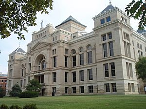
Old Sedgwick County Courthouse in Wichita (2009)
|
|

Location within the U.S. state of Kansas
|
|
 Kansas's location within the U.S. |
|
| Country | |
| State | |
| Founded | February 26, 1867 |
| Named for | John Sedgwick |
| Seat | Wichita |
| Largest city | Wichita |
| Area | |
| • Total | 1,009 sq mi (2,610 km2) |
| • Land | 998 sq mi (2,580 km2) |
| • Water | 12 sq mi (30 km2) 1.2% |
| Population
(2020)
|
|
| • Total | 523,824 |
| • Estimate
(2023)
|
528,469 |
| • Density | 524.9/sq mi (202.7/km2) |
| Time zone | UTC−6 (Central) |
| • Summer (DST) | UTC−5 (CDT) |
| Area code | 316 |
| Congressional district | 4th |
Sedgwick County is located in the U.S. state of Kansas. Its county seat is Wichita, the most populous city in the state. As of the 2020 census, the population was 523,824, making it the second-most populous county in Kansas. The county was named for John Sedgwick, the highest ranking Union general killed during the American Civil War.
Contents
History
Early history
For many millennia, the Great Plains of North America was inhabited by nomadic Native Americans. From the 16th century to 18th century, the Kingdom of France claimed ownership of large parts of North America. In 1762, after the French and Indian War, France secretly ceded New France to Spain, per the Treaty of Fontainebleau. In 1802, Spain returned most of the land to France, but keeping title to about 7,500 square miles.
In 1803, most of the land for modern day Kansas was acquired by the United States from France as part of the 828,000 square mile Louisiana Purchase for 2.83 cents per acre. In 1848, after the Mexican-American War, the Treaty of Guadalupe Hidalgo with Spain brought into the United States all or part of land for ten future states, including southwest Kansas. In 1854, the Kansas Territory was organized, then in 1861 Kansas became the 34th U.S. state.
19th century
Sedgwick County was founded in 1867, and named after John Sedgwick, who was a Major General in the Union Army during the American Civil War.
In 1887, the Chicago, Kansas and Nebraska Railway built a branch line north-south from Herington to Caldwell. This branch line connected Herington, Lost Springs, Lincolnville, Antelope, Marion, Aulne, Peabody, Elbing, Whitewater, Furley, Kechi, Wichita, Peck, Corbin, Wellington, Caldwell. By 1893, this branch line was incrementally built to Fort Worth, Texas. This line is called the "OKT". The Chicago, Kansas and Nebraska Railway was foreclosed in 1891 and was taken over by Chicago, Rock Island and Pacific Railway, which shut down in 1980 and reorganized as Oklahoma, Kansas and Texas Railroad, merged in 1988 with Missouri Pacific Railroad, and finally merged in 1997 with Union Pacific Railroad. Most locals still refer to this railroad as the "Rock Island".
20th century
Sedgwick County was the setting for the murders committed by the BTK strangler from 1974 until 1991.
Geography
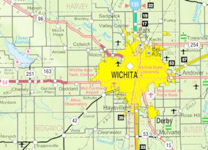
According to the U.S. Census Bureau, the county has a total area of 1,009 square miles (2,610 km2), of which 998 square miles (2,580 km2) is land and 12 square miles (31 km2) (1.2%) is water.
Adjacent counties
- Harvey County (north)
- Butler County (east)
- Cowley County (southeast)
- Sumner County (south)
- Kingman County (west)
- Reno County (northwest)
Demographics

| Historical population | |||
|---|---|---|---|
| Census | Pop. | %± | |
| 1870 | 1,095 | — | |
| 1880 | 18,753 | 1,612.6% | |
| 1890 | 43,626 | 132.6% | |
| 1900 | 44,037 | 0.9% | |
| 1910 | 73,095 | 66.0% | |
| 1920 | 92,234 | 26.2% | |
| 1930 | 136,330 | 47.8% | |
| 1940 | 143,311 | 5.1% | |
| 1950 | 222,290 | 55.1% | |
| 1960 | 343,231 | 54.4% | |
| 1970 | 350,694 | 2.2% | |
| 1980 | 366,531 | 4.5% | |
| 1990 | 403,662 | 10.1% | |
| 2000 | 452,869 | 12.2% | |
| 2010 | 498,365 | 10.0% | |
| 2020 | 523,824 | 5.1% | |
| 2023 (est.) | 528,469 | 6.0% | |
| U.S. Decennial Census 1790-1960 1900–1990 1990-2000 2010–2020 |
|||
Sedgwick County is part of the Wichita, KS Metropolitan Statistical Area.
As of the census of 2000, there were 452,869 people, 176,444 households, and 117,688 families residing in the county. The population density was 453 inhabitants per square mile (175/km2). There were 191,133 housing units at an average density of 191 per square mile (74/km2). The racial makeup of the county was 79.38% White, 9.13% Black or African American, 1.11% Native American, 3.34% Asian, 0.06% Pacific Islander, 4.17% from other races, and 2.81% from two or more races. 8.04% of the population were Hispanic or Latino of any race.
There were 176,444 households, out of which 34.40% had children under the age of 18 living with them, 51.70% were married couples living together, 10.90% had a female householder with no husband present, and 33.30% were non-families. 28.20% of all households were made up of individuals, and 8.70% had someone living alone who was 65 years of age or older. The average household size was 2.53 and the average family size was 3.14.
In the county, the population was spread out, with 28.20% under the age of 18, 9.50% from 18 to 24, 30.30% from 25 to 44, 20.60% from 45 to 64, and 11.40% who were 65 years of age or older. The median age was 34 years. For every 100 females, there were 97.80 males. For every 100 females age 18 and over, there were 95.20 males.
The median income for a household in the county was $42,485, and the median income for a family was $51,645. Males had a median income of $37,770 versus $26,153 for females. The per capita income for the county was $20,907. About 7.00% of families and 9.50% of the population were below the poverty line, including 11.90% of those under age 18 and 7.00% of those age 65 or over.
Economy
It is the birthplace of famous restaurants such as White Castle and Pizza Hut. It is also the aviation headquarters of well-known Cessna and Learjet.
Transportation
Airports
The following public-use airports are located in Sedgwick County:
- Wichita Dwight D. Eisenhower National Airport (ICT)
- Beech Factory Airport (BEC)
- Cessna Aircraft Field (CEA)
- Colonel James Jabara Airport (AAO)
- Cook Airfield (K50)
- Maize Airport (70K)
- Westport Airport (71K)
- Westport Auxiliary Airport (72K)
The following are closed airports:
- Riverside Airport (K32)
Education
Colleges and universities
- Friends University
- Kansas College of Osteopathic Medicine
- Newman University
- University of Kansas School of Medicine
- WSU Tech
- Wichita State University
Unified school districts
School districts include:
- Andover USD 385
- Burrton USD 369
- Cheney USD 268
- Circle USD 375
- Clearwater USD 264
- Conway Springs USD 356
- Derby USD 260
- Goddard USD 265
- Halstead–Bentley USD 440
- Haven USD 312
- Haysville USD 261
- Kingman-Norwich USD 331
- Maize USD 266
- Mulvane USD 263
- Remington USD 206
- Renwick USD 267
- Rose Hill USD 394
- Sedgwick USD 439
- Valley Center USD 262
- Wichita USD 259
Points of interest
- Sedgwick County Extension Arboretum
- Sedgwick County Zoo
- Sedgwick County Fair
- Wichita-Sedgwick County Historical Museum
- INTRUST Bank Arena
Communities
Cities
Census-designated places
- McConnell AFB
- Oaklawn-Sunview
Unincorporated places
Ghost towns
- Davidson
- Hatfield
- Huckle
- Jamesburg
- Marshall
- Oatville
- Wichita Heights
Townships
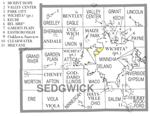
Sedgwick County is divided into twenty-seven townships. The cities of Bel Aire and Wichita are considered governmentally independent and are excluded from the census figures for the townships. In the following table, the population center is the largest city (or cities) included in that township's population total, if it is of a significant size. The county use to have one more township, Wichita Township, but it no longer exists.
| Township | FIPS | Population center |
Population | Population density /km² (/sq mi) |
Land area km² (sq mi) |
Water area km² (sq mi) |
Water % | Geographic coordinates |
|---|---|---|---|---|---|---|---|---|
| Afton | 00425 | 1,290 | 14 (37) | 91 (35) | 2 (1) | 1.73% | 37°36′10″N 97°37′54″W / 37.60278°N 97.63167°W | |
| Attica | 03125 | Goddard | 4,959 | 62 (161) | 80 (31) | 0 (0) | 0.23% | 37°40′44″N 97°32′16″W / 37.67889°N 97.53778°W |
| Delano | 17375 | 196 | 25 (64) | 8 (3) | 1 (0) | 13.81% | 37°43′2″N 97°25′13″W / 37.71722°N 97.42028°W | |
| Eagle | 19250 | Bentley | 1,069 | 12 (30) | 92 (36) | 1 (1) | 1.44% | 37°51′48″N 97°32′26″W / 37.86333°N 97.54056°W |
| Erie | 21550 | 106 | 1 (3) | 94 (36) | 0 (0) | 0.03% | 37°31′24″N 97°44′51″W / 37.52333°N 97.74750°W | |
| Garden Plain | 25400 | Garden Plain | 1,780 | 19 (50) | 92 (36) | 0 (0) | 0.15% | 37°40′25″N 97°39′47″W / 37.67361°N 97.66306°W |
| Grand River | 27300 | 607 | 7 (17) | 91 (35) | 2 (1) | 2.20% | 37°40′6″N 97°45′14″W / 37.66833°N 97.75389°W | |
| Grant | 28125 | Valley Center (part) | 3,710 | 40 (104) | 93 (36) | 0 (0) | 0.47% | 37°50′55″N 97°20′23″W / 37.84861°N 97.33972°W |
| Greeley | 28400 | Mount Hope | 1,094 | 12 (31) | 93 (36) | 1 (1) | 1.43% | 37°52′21″N 97°39′17″W / 37.87250°N 97.65472°W |
| Gypsum | 29300 | 5,822 | 64 (164) | 92 (35) | 0 (0) | 0.51% | 37°36′26″N 97°12′34″W / 37.60722°N 97.20944°W | |
| Illinois | 33775 | 1,620 | 18 (45) | 93 (36) | 0 (0) | 0.12% | 37°35′54″N 97°31′53″W / 37.59833°N 97.53139°W | |
| Kechi | 36250 | Park City | 8,041 | 143 (370) | 56 (22) | 0 (0) | 0.23% | 37°47′35″N 97°19′14″W / 37.79306°N 97.32056°W |
| Lincoln | 41150 | 473 | 5 (13) | 91 (35) | 0 (0) | 0.12% | 37°52′35″N 97°11′53″W / 37.87639°N 97.19806°W | |
| Minneha | 47125 | Eastborough | 5,084 | 117 (304) | 43 (17) | 1 (0) | 1.49% | 37°41′11″N 97°11′25″W / 37.68639°N 97.19028°W |
| Morton | 48550 | Cheney | 2,380 | 26 (67) | 91 (35) | 1 (0) | 1.14% | 37°37′24″N 97°46′33″W / 37.62333°N 97.77583°W |
| Ninnescah | 50725 | Clearwater | 2,913 | 31 (81) | 93 (36) | 0 (0) | 0.47% | 37°30′51″N 97°31′28″W / 37.51417°N 97.52444°W |
| Ohio | 52450 | 1,146 | 12 (32) | 94 (36) | 0 (0) | 0.14% | 37°31′56″N 97°25′21″W / 37.53222°N 97.42250°W | |
| Park | 54425 | Maize | 4,128 | 51 (131) | 82 (32) | 2 (1) | 2.04% | 37°46′26″N 97°26′13″W / 37.77389°N 97.43694°W |
| Payne | 55075 | 1,119 | 14 (36) | 80 (31) | 0 (0) | 0.21% | 37°46′58″N 97°12′22″W / 37.78278°N 97.20611°W | |
| Riverside | 60125 | Haysville (part) Derby (part) Oaklawn-Sunview CDP |
15,694 | 333 (862) | 47 (18) | 1 (0) | 1.98% | 37°34′56″N 97°18′22″W / 37.58222°N 97.30611°W |
| Rockford | 60675 | Derby (part) | 20,019 | 198 (514) | 101 (39) | 1 (0) | 0.99% | 37°31′55″N 97°14′47″W / 37.53194°N 97.24639°W |
| Salem | 62675 | Haysville (part) | 8,411 | 102 (263) | 83 (32) | 1 (0) | 0.95% | 37°32′23″N 97°20′11″W / 37.53972°N 97.33639°W |
| Sherman | 65100 | Andale | 1,362 | 14 (37) | 96 (37) | 0 (0) | 0.22% | 37°47′23″N 97°38′4″W / 37.78972°N 97.63444°W |
| Union | 72375 | Colwich | 2,156 | 23 (60) | 93 (36) | 0 (0) | 0.23% | 37°46′55″N 97°32′8″W / 37.78194°N 97.53556°W |
| Valley Center | 73275 | Valley Center (part) | 3,642 | 39 (100) | 94 (36) | 0 (0) | 0.16% | 37°51′22″N 97°24′10″W / 37.85611°N 97.40278°W |
| Viola | 74050 | Viola | 547 | 6 (15) | 93 (36) | 1 (0) | 0.98% | 37°30′41″N 97°39′3″W / 37.51139°N 97.65083°W |
| Waco | 74300 | 3,381 | 45 (117) | 75 (29) | 0 (0) | 0.12% | 37°36′35″N 97°24′57″W / 37.60972°N 97.41583°W |
See also
 In Spanish: Condado de Sedgwick (Kansas) para niños


