Second Severn Crossing facts for kids
Quick facts for kids Second Severn Crossing |
|
|---|---|

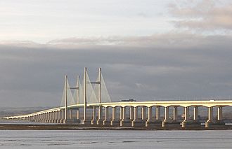
The bridge as viewed from Severn Beach (England)
|
|
| Coordinates | 51°34′28″N 2°42′06″W / 51.5745°N 2.7016°W |
| Carries | M4 motorway (6 lanes) |
| Crosses | River Severn |
| Locale | South West England/South East Wales |
| Official name | Prince of Wales Bridge |
| Maintained by | Highways England |
| Characteristics | |
| Design | Central span: Cable-stayed bridge Approach viaducts: Segmental bridge |
| Total length | 5,128 metres (16,824 ft) |
| Width | 34.6 metres (113.5 ft) |
| Height | 137 metres (449 ft) |
| Longest span | 456 metres (1,496 ft) |
| Clearance below | 37 metres (121 ft) |
| History | |
| Opened | 5 June 1996 |
| Statistics | |
| Toll | Free |
The Second Severn Crossing (Welsh: Ail Groesfan Hafren) is a bridge over the River Severn between South Gloucestershire in England and Monmouthshire in Wales.
The bridge carries the M4 motorway and is one of the main routes into South Wales. It was opened on 5 June 1996 to allow more traffic than the original Severn Bridge, which opened in 1966. Both bridges are still in use although the newer crossing is more direct and less likely to be closed in strong winds.
Images for kids
-
A dunlin feeding, one of the many waders that winter on the Severn estuary

All content from Kiddle encyclopedia articles (including the article images and facts) can be freely used under Attribution-ShareAlike license, unless stated otherwise. Cite this article:
Second Severn Crossing Facts for Kids. Kiddle Encyclopedia.


