Santa Bárbara Department, Honduras facts for kids
Quick facts for kids
Santa Bárbara Department
Departamento de Santa Bárbara
|
|
|---|---|
|
department
|
|

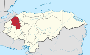
Location of Santa Bárbara in Honduras
|
|
| Country | |
| Municipalities | 28 |
| Villages | 370 |
| Founded | 28 June 1825 |
| Capital city | Santa Bárbara |
| Government | |
| • Type | Departmental |
| Area | |
| • Total | 5,013 km2 (1,936 sq mi) |
| Population
(2015)
|
|
| • Total | 434,896 |
| • Density | 86.754/km2 (224.691/sq mi) |
| Time zone | UTC-6 (CDT) |
| Postal code |
22101
|
| ISO 3166 code | HN-SB |
| HDI (2017) | 0.584 medium · 10th |
| Statistics derived from Consult INE online database: Population and Housing Census 2013 | |
Santa Bárbara is one of the 18 departments (departamentos) into which Honduras is divided. The departmental capital is Santa Bárbara.
Contents
Geography
The department covers a total surface area of 5,115 km² and, in 2005, had an estimated population of 368,298 people.
Economy
The department, historically, is known for harvesting mahogany and cedar trees for exportation.
Municipalities
- Arada
- Atima
- Azacualpa
- Ceguaca
- Chinda
- Concepción del Norte
- Concepción del Sur
- El Nispero
- Gualala
- Ilama
- Las Vegas
- Macuelizo
- Naranjito
- Nueva Frontera
- Nuevo Celilac
- Petoa
- Protección
- Quimistán
- San Francisco de Ojuera
- San José de Colinas
- San Luis
- San Marcos
- San Nicolás
- San Pedro Zacapa
- Santa Bárbara
- Santa Rita
- San Vicente Centenario
- Trinidad
See also
 In Spanish: Departamento de Santa Bárbara (Honduras) para niños

All content from Kiddle encyclopedia articles (including the article images and facts) can be freely used under Attribution-ShareAlike license, unless stated otherwise. Cite this article:
Santa Bárbara Department, Honduras Facts for Kids. Kiddle Encyclopedia.
