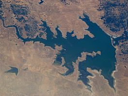
Salt Spring Valley Reservoir facts for kids
Quick facts for kids Salt Spring Valley Reservoir |
|
|---|---|
 |
|
| Location | Calaveras County, California |
| Coordinates | 38°02′07″N 120°45′03″W / 38.03538°N 120.75090°W |
| Lake type | Reservoir |
| Primary outflows | Mokelumne River |
| Catchment area | 169 sq mi (440 km2) |
| Basin countries | United States |
| Surface area | 975 acres (395 ha) |
| Water volume | 10,900 acre⋅ft (13,400,000 m3) |
| Surface elevation | 328 m (1,076 ft) |
Salt Spring Valley Reservoir is an artificial lake formed by the construction of Salt Springs Valley Dam across Rock Creek in the Bear Mountains of Calaveras County, California.

All content from Kiddle encyclopedia articles (including the article images and facts) can be freely used under Attribution-ShareAlike license, unless stated otherwise. Cite this article:
Salt Spring Valley Reservoir Facts for Kids. Kiddle Encyclopedia.

