Saarland facts for kids
Quick facts for kids
The Saar
Saarland
|
|||
|---|---|---|---|
|
|||

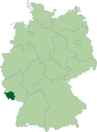
Position of the Saarland in Germany
|
|||
| Country | Germany | ||
| Capital | Saarbrücken | ||
| Area | |||
| • Total | 2,569 km2 (992 sq mi) | ||
| Population
(2011)
|
|||
| • Total | 1,014,000 | ||
| • Density | 394.71/km2 (1,022.3/sq mi) | ||
| Time zone | UTC+1 (CET) | ||
| • Summer (DST) | UTC+2 (CEST) | ||
| Website | saarland.de | ||
Saarland is a Bundesland (state) of Germany. It has an area of 2,568.45 km2 (991.7 sq mi) and 1,014,000 people living in it (2011). Saarland lies in the south-west of Germany, near the French border near Metz. The capital is Saarbrücken.
History
In 1920, the Treaty of Versailles made Saarland from parts of the Prussian Rhine Province (1,465 km2 (565.6 sq mi)) and the Rhine Palatinate (416 km2 (160.6 sq mi)). The area was put under the control of the League of Nations for 15 years. After a plebiscite (vote) in 1935, Germany got the land back. After World War II the Saarland came under French administration. The Saar Protectorate was allowed its own government for most things in 1947 but not independence. Germany got the Saarland back in 1957 and it became a Bundesland.
Geography
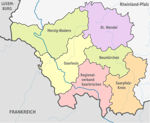
In the south is France, in the north-west Luxembourg and in the north and east is Rhineland-Palatinate.
Saarland is divided in 6 districts:
- Merzig-Wadern (the largest district)
- Neunkirchen
- Saarbrücken
- Saarlouis
- Saarpfalz (Saar-Palatinate)
- Sankt Wendel
City and towns
- Saarbrücken (city)
- Neunkirchen
- Saarlouis
- Homburg
- Merzig
Related pages
Images for kids
See also
 In Spanish: Sarre para niños


