Rutherglen Central and North (ward) facts for kids
Quick facts for kids Rutherglen Central and North |
|
|---|---|
| South Lanarkshire | |

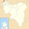
Boundary of Rutherglen Central and North in South Lanarkshire from 2007–2017.
|
|
| Population | 14,237 (2021) |
| Electorate | 11,692 (2022) |
| Major settlements | Rutherglen (part of) |
| Scottish Parliament constituency | Rutherglen |
| Scottish Parliament region | Glasgow |
| UK Parliament constituency | Rutherglen and Hamilton West |
| Current ward | |
| Created | 2007 |
| Number of councillors | 3 |
| Councillor | Martin Lennon (Labour) |
| Councillor | Janine Calikes (SNP) |
| Councillor | Andrea Cowan (SNP) |
| Created from | Bankhead Burgh Rutherglen West Stonelaw |
Rutherglen Central and North is one of the 20 electoral wards of South Lanarkshire Council. Created in 2007, the ward elects three councillors using the single transferable vote electoral system and covers an area with a population of 14,237 people.
The ward was previously a Labour stronghold with the party holding two of the three seats from 2007 to 2017 however, the ward has since swung to the Scottish National Party (SNP) who won two of the three seats at the 2022 election.
Contents
Boundaries
The ward was created following the Fourth Statutory Reviews of Electoral Arrangements ahead of the 2007 Scottish local elections. As a result of the Local Governance (Scotland) Act 2004, local elections in Scotland would use the single transferable vote electoral system from 2007 onwards so Rutherglen Central and North was formed from an amalgamation of several previous first-past-the-post wards. It contained the vast majority of the former Bankhead ward, all of the former Burgh and Rutherglen West wards as well as a small part of the former Stonelaw ward. Rutherglen North covers a suburban area in the north of Rutherglen – the northernmost part of South Lanarkshire – including the neighbourhoods of Burgh, Bankhead, Burnhill, Gallowflat and Farme Cross as well as the unpopulated Shawfield industrial area. The ward's northern and western boundary is the long-established division with Glasgow City Council, part of which runs along the River Clyde.
Prior to the local government reforms in the 1990s, Rutherglen was within the Glasgow District under Strathclyde Regional Council. One of its single-member wards was Rutherglen, which included much of the same area as the current Rutherglen Central and North, with the exception of the Burnhill and Newfield neighbourhoods and the addition of the parts of Burnside north of the Cathcart Circle Line railway tracks.
Following the Fifth Statutory Reviews of Electoral Arrangements ahead of the 2017 Scottish local elections, streets around Overtoun Park, Dryburgh Avenue and Limeside Avenue were transferred into the ward from Rutherglen South.
Councillors
| Election | Councillors | |||||||
|---|---|---|---|---|---|---|---|---|
| 2007 | Edward McAvoy (Labour) |
Denis McKenna (Labour) |
Gordon Clark (SNP) |
|||||
| 2012 | ||||||||
| 2017 | Gerard Killen (Labour) |
Jared Wark (Conservative) |
Janine Calikes (SNP) |
|||||
| 2017 by-election | Martin Lennon (Labour) |
|||||||
| 2022 | Andrea Cowan (SNP) |
|||||||
Election results
2022 election
2022 South Lanarkshire Council election
2017 by-election
2017 South Lanarkshire Council election
2017 election
2017 South Lanarkshire Council election
2012 election
2012 South Lanarkshire Council election
2007 election
2007 South Lanarkshire Council election


