Roundtop Mountain (Alaska) facts for kids
Quick facts for kids Roundtop Mountain |
|
|---|---|

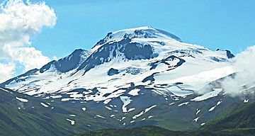
East aspect from False Pass
|
|
| Highest point | |
| Elevation | 6,100 ft (1,900 m) |
| Prominence | 3,000 ft (910 m) |
| Geography | |
| Parent range | Aleutian Range |
| Topo map | USGS False Pass D-5 |
| Geology | |
| Mountain type | Stratovolcano |
| Volcanic arc/belt | Aleutian Arc |
| Last eruption | 9,100-10,000 years ago |
Roundtop Mountain is a stratovolcano located on the Aleutian island of Unimak in the U.S. state of Alaska. Its last eruption was sometime between 9,100 and 10,000 years ago. This geographic feature was first called "Dome" in 1897 by Lieutenant Commander J. F. Moser, of the U.S. Navy. Its name was reported as "Round Top" by the U.S. Coast and Geodetic Survey in 1902. Isanotski Peaks, the nearest higher neighbor, is positioned 5.9 mi (9 km) to the west-southwest.

All content from Kiddle encyclopedia articles (including the article images and facts) can be freely used under Attribution-ShareAlike license, unless stated otherwise. Cite this article:
Roundtop Mountain (Alaska) Facts for Kids. Kiddle Encyclopedia.
