Rockbridge, Ohio facts for kids
Quick facts for kids
Rockbridge, Ohio
|
|
|---|---|

Houses on Jackson Street south of the post office
|
|

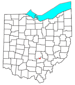
Location of Rockbridge, Ohio
|
|
| Country | United States |
| State | Ohio |
| County | Hocking |
| Township | Good Hope |
| Area | |
| • Total | 0.38 sq mi (0.98 km2) |
| • Land | 0.38 sq mi (0.98 km2) |
| • Water | 0.00 sq mi (0.00 km2) |
| Elevation | 846 ft (258 m) |
| Population
(2020)
|
|
| • Total | 160 |
| • Density | 423.28/sq mi (163.55/km2) |
| Time zone | UTC-5 (Eastern (EST)) |
| • Summer (DST) | UTC-4 (EDT) |
| ZIP code |
43149
|
| Area code(s) | 740 |
| FIPS code | 39-67804 |
| GNIS feature ID | 2628962 |
Rockbridge is an unincorporated community and census-designated place (CDP) in eastern Good Hope Township, Hocking County, Ohio, United States. It has a post office with the ZIP code 43149. It is located at the interchange of U.S. Route 33 and State Route 374, between Logan and Lancaster. As of the 2020 census the population of the CDP was 160.
History
A post office called Rockbridge has been in operation since 1863. The community is named after a natural bridge that is located to the east in the Rockbridge State Nature Preserve. The bridge is formed of sandstone and stretches more than 100 feet (30 m) long and 10 to 20 feet (3.0 to 6.1 m) wide over a ravine on a small tributary of the Hocking River.
Demographics
| Historical population | |||
|---|---|---|---|
| Census | Pop. | %± | |
| 2020 | 160 | — | |
| U.S. Decennial Census | |||
See also
 In Spanish: Rockbridge (Ohio) para niños

All content from Kiddle encyclopedia articles (including the article images and facts) can be freely used under Attribution-ShareAlike license, unless stated otherwise. Cite this article:
Rockbridge, Ohio Facts for Kids. Kiddle Encyclopedia.
