River Parrett facts for kids
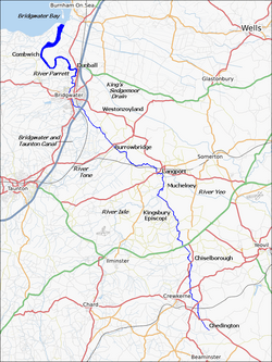
The River Parrett is a major river in Somerset and Dorset, England. It starts in the County of Dorset near Chedington. From here it flows in a northwesterly direction through the Somerset Levels to Bridgewater. It flows into the Bristol Channel close to Burnham-on-Sea. At the mouth of the river is Bridgewater Bay National Nature Reserve. The river is tidal for 18.6 miles (29.9 km) up to the hamlet of Oath, some 10 miles (16 km) south east of Bridgewater. The river has a very slight fall between Langport and Bridgwater, only 1 foot per mile, or 20 cm per km, and is prone to frequent flooding, in winter and high tides.
The River Parrett is 37 miles (60 km) long and its main tributaries include the Rivers Tone, Isle and Yeo. The River Cary drains into the Parrett via the King's Sedgemoor Drain. The River Parrett drains an area of over 1,690 square kilometres (650 sq mi), making up around 50% of the land area of Somerset.
Images for kids
-
Aerial view of the mouth of the River Parrett as it flows into Bridgwater Bay
-
The river near Pawlett showing Hinkley Point power stations A and B
-
The river near the A303 at South Petherton
-
The flooded Southlake Moor in the winter of 1985
-
Dunball Wharf. To the right is Dunball clyce where the King's Sedgemoor Drain flows into the River Parrett.
-
Great Bow Bridge at Langport
-
Monk's Leaze clyce. This sluice regulates the flow of water between the River Parrett and the Sowy River (the River Parrett Relief Channel).
-
View from the summit of Burrow Mump across the winter-flooded Somerset levels toward Aller Hill and the village of Aller, Somerset.
-
Tidal mudflats at Combwich, near the mouth of the River Parrett on Bridgwater Bay


