Ringgold County, Iowa facts for kids
Quick facts for kids
Ringgold County
|
|
|---|---|

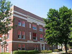
Ringgold County Courthouse in Mount Ayr
|
|

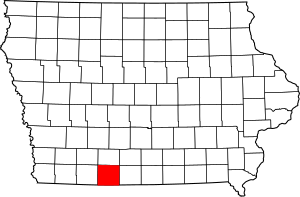
Location within the U.S. state of Iowa
|
|
 Iowa's location within the U.S. |
|
| Country | |
| State | |
| Founded | February 24, 1847 |
| Named for | Samuel Ringgold |
| Seat | Mount Ayr |
| Largest city | Mount Ayr |
| Area | |
| • Total | 539 sq mi (1,400 km2) |
| • Land | 535 sq mi (1,390 km2) |
| • Water | 3.4 sq mi (9 km2) 0.6% |
| Population
(2020)
|
|
| • Total | 4,663 |
| • Density | 8.651/sq mi (3.340/km2) |
| Time zone | UTC−6 (Central) |
| • Summer (DST) | UTC−5 (CDT) |
| Congressional district | 3rd |
Ringgold County is a county located in the U.S. state of Iowa. As of the 2020 census, the population was 4,663, making it the Iowa county with the second-smallest population. The county seat is Mount Ayr. The county is named after Maj. Samuel Ringgold, a hero of the Battle of Palo Alto fought in May 1846, during the Mexican–American War. It is one of the 26 Iowa counties with a name that is unique across the nation.
Contents
Geography
According to the U.S. Census Bureau, the county has a total area of 539 square miles (1,400 km2), of which 535 square miles (1,390 km2) is land and 3.4 square miles (8.8 km2) (0.6%) is water.
Major highways
Adjacent counties
- Union County (north)
- Decatur County (east)
- Harrison County, Missouri (southeast)
- Worth County, Missouri (southwest)
- Taylor County (west)
Demographics
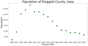
| Historical population | |||
|---|---|---|---|
| Census | Pop. | %± | |
| 1860 | 2,923 | — | |
| 1870 | 5,691 | 94.7% | |
| 1880 | 12,085 | 112.4% | |
| 1890 | 13,556 | 12.2% | |
| 1900 | 15,325 | 13.0% | |
| 1910 | 12,904 | −15.8% | |
| 1920 | 12,919 | 0.1% | |
| 1930 | 11,966 | −7.4% | |
| 1940 | 11,137 | −6.9% | |
| 1950 | 9,528 | −14.4% | |
| 1960 | 7,910 | −17.0% | |
| 1970 | 6,373 | −19.4% | |
| 1980 | 6,112 | −4.1% | |
| 1990 | 5,420 | −11.3% | |
| 2000 | 5,469 | 0.9% | |
| 2010 | 5,131 | −6.2% | |
| 2020 | 4,663 | −9.1% | |
| 2023 (est.) | 4,642 | −9.5% | |
| U.S. Decennial Census 1790-1960 1900-1990 1990-2000 2010-2018 |
|||
2020 census

The 2020 census recorded a population of 4,663 in the county, with a population density of 8.6265/sq mi (3.3307/km2). 96.68% of the population reported being of one race. 94.32% were non-Hispanic White, 0.06% were Black, 1.52% were Hispanic, 0.15% were Native American, 0.17% were Asian, 0.02% were Native Hawaiian or Pacific Islander and 3.75% were some other race or more than one race. There were 2,672 housing units, of which 1,945 were occupied.
2010 census
The 2010 census recorded a population of 5,131 in the county, with a population density of 9.5430/sq mi (3.6846/km2). There were 2,613 housing units, of which 2,047 were occupied.
Communities
Cities
Census-designated place
Townships
- Athens
- Benton
- Clinton
- Grant
- Jefferson
- Liberty
- Lincoln
- Lotts Creek
- Middle Fork
- Monroe
- Poe
- Rice
- Riley
- Tingley
- Union
- Washington
- Waubonsie
Population ranking
The population ranking of the following table is based on the 2020 census of Ringgold County.
† county seat
| Rank | City/Town/etc. | Municipal type | Population (2020 Census) |
|---|---|---|---|
| 1 | † Mount Ayr | City | 1,623 |
| 2 | Diagonal | City | 344 |
| 3 | Kellerton | City | 243 |
| 4 | Sun Valley Lake | CDP | 187 |
| 5 | Tingley | City | 136 |
| 6 | Redding | City | 63 |
| 7 | Benton | City | 39 |
| 8 | Delphos | CDP | 26 |
| 9 | Maloy | City | 22 |
| 10 | Ellston | City | 19 |
| 11 | Beaconsfield | City | 15 |
| 12 | Clearfield (mostly in Taylor County) | City | 6 (278 total) |
| 13 | Shannon City (partially in Union County) | City | 6 (73 total) |
Education
School districts include:
- Bedford Community School District
- Creston Community School District
- Diagonal Community School District
- East Union Community School District
- Lamoni Community School District
- Lenox Community School District
- Mount Ayr Community School District
Former school districts:
- Clearfield Community School District - Dissolved on July 1, 2014.
See also
 In Spanish: Condado de Ringgold para niños


