Rijnwoude facts for kids
"Rijneveld" redirects here. For the writer, see Marieke Lucas Rijneveld.
Quick facts for kids
Rijnwoude
|
|||
|---|---|---|---|
|
Former municipality
|
|||

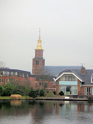
Church in Hazerswoude-Dorp
|
|||
|
|||

Location in South Holland
|
|||
| Country | Netherlands | ||
| Province | South Holland | ||
| Municipality | Alphen aan den Rijn | ||
| Established | 1 January 1991 | ||
| Dissolved | 1 January 2014 | ||
| Area | |||
| • Total | 57.89 km2 (22.35 sq mi) | ||
| • Land | 56.69 km2 (21.89 sq mi) | ||
| • Water | 1.20 km2 (0.46 sq mi) | ||
| Elevation | −1 m (−3.3 ft) | ||
| Population
(November 2013)
|
|||
| • Total | 18,523 | ||
| • Density | 327/km2 (850/sq mi) | ||
| Time zone | UTC+1 (CET) | ||
| • Summer (DST) | UTC+2 (CEST) | ||
| Postcode |
2390–2396, 2730–2731
|
||
| Area code | 0172, 071, 079 | ||
Rijnwoude (Dutch pronunciation: [ˈrɛiɱˌʋʌudə]) was a municipality in the western Netherlands, in the province of South Holland. The municipality covered an area of 57.89 km2 (22.35 sq mi) of which 1.20 km2 (0.46 sq mi) was water.
Rijnwoude was formed in 1991 as Rijneveld through the merger of the former municipalities of Benthuizen, Hazerswoude and Koudekerk aan den Rijn. In 1993 the municipality was renamed to Rijnwoude. In 2014 the municipality was dissolved and its land area was amalgamated into Alphen aan den Rijn.
The municipality of Rijnwoude consisted of the communities Benthorn, Benthuizen, Hazerswoude-Dorp, Groenendijk, Hazerswoude-Rijndijk (location of town hall), Hogeveen, and Koudekerk aan den Rijn.

All content from Kiddle encyclopedia articles (including the article images and facts) can be freely used under Attribution-ShareAlike license, unless stated otherwise. Cite this article:
Rijnwoude Facts for Kids. Kiddle Encyclopedia.


