Richwoods, Missouri facts for kids
Quick facts for kids
Richwoods, Missouri
|
|
|---|---|

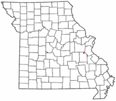
Location of Richwoods, Missouri
|
|
| Country | United States |
| State | Missouri |
| County | Washington |
| Settled | 1830 |
| Elevation | 810 ft (250 m) |
| ZIP code |
63071
|
| Area code(s) | 573 |
| GNIS feature ID | 725284 |
Richwoods is an unincorporated community in northeastern Washington County, Missouri, United States. It is located on Missouri Route A one mile east of Missouri Route 47, approximately 15 miles west of De Soto and 19 miles south of St. Clair.
History
The first settlement at Richwoods was made ca. 1830. The community was named for the dense forest near the original town site. A post office has been in operation at Richwoods since 1832.
Education
The Richwoods area is served by the Richwoods School District (R-7). They offer pre-school and kindergarten through eighth grade. After the completion of the eighth grade, students may choose to attend high schools in the following areas: Potosi, Grandview, Kingston, DeSoto, St. Clair, or Sullivan.
Churches and cemeteries
- The Book of Acts Church
- Church Apostolic
- Richwoods 1st Free Will Baptist Church
- Cross Roads Baptist Church
- The Way of Life Tabernacle
- Horine Methodist church and cemetery
The St. Stephen Catholic Church parish and cemetery was established in 1841. St. Stephen Cemetery is located behind the church and rectory.


