Remembrance Driveway (Australia) facts for kids
Quick facts for kids Remembrance DrivewayNew South Wales–Australian Capital Territory |
|
|---|---|
 |
|
| General information | |
| Type | Road |
| Opened | 5 February 1954 |
| Major junctions | |
| ne end | Macquarie Place Sydney central business district |
| sw end | Treloar Crescent Australian War Memorial, Canberra |
| Highway system | |
| Highways in Australia National Highway • Freeways in Australia Highways in New South Wales Road infrastructure in Canberra |
|
| Remembrance Driveway | |
|---|---|
| Australia | |

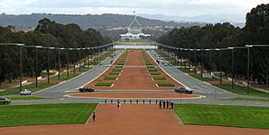
The Remembrance Driveway in Canberra, from a view on the steps of the Australian War Memorial.
|
|
| Used for those deceased | |
| Established | 5 February 1954 |
| Location | Between Macquarie Place, Sydney and the Australian War Memorial, Canberra |
The Remembrance Driveway in Australia is a road and memorial system of arboreal parks, plantations, and road-side rest areas that provide a living memorial in honour of those who served in the Australian Defence Forces in World War II, the Korean War, Malayan Emergency and the Vietnam War, and who continue to serve around the world. The most prominent feature of the driveway are a series of rest areas dedicated in honour of the Australian Victoria Cross recipients from World War II onwards.
Route
The northeastern terminus of the Remembrance Driveway is in Macquarie Place, Sydney, and follows the 320-kilometre (200 mi) Hume Highway, Hume Motorway, a small section of the Old Hume Highway, and Federal Highway between Sydney, the state capital of New South Wales, and Canberra, the national capital, where its southwestern terminus is at Remembrance Park, adjacent to the Australian War Memorial.
The Remembrance Driveway was instituted in 1954 when Queen Elizabeth II and the Duke of Edinburgh marked the beginning of the Driveway by planting two plane trees in Macquarie Place.
Rest areas
The Victoria Cross rest areas and memorial parks sited along the Driveway honour the 24 Australian World War II and Vietnam War Victoria Cross winners.
| Road | State/Terr. | Location | Rest area name | Established | Coordinates | Honouree | Notes |
|---|---|---|---|---|---|---|---|
| Ash Road, north of Camden Valley Way |
NSW | Prestons | Sir Roden Cutler VC | 2006 | 33°57′11″S 150°52′25″E / 33.9531°S 150.8737°E | Sir Roden Cutler VC, AK, KCMG, KCVO, CBE | |
| Hume Motorway | Menangle | Partridge VC | 2003 | 34°09′25″S 150°44′19″E / 34.1569°S 150.7385°E | Frank Partridge VC | ||
| Pheasants Nest | Kenna VC | 2012 | 34°14′47″S 150°39′30″E / 34.2464°S 150.6582°E | Edward Kenna VC | |||
| Hume Highway | Sutton Forest | Gordon VC | 2001 | 34°32′07″S 150°16′53″E / 34.5352°S 150.2814°E | Jim Gordon VC | ||
| Moss Vale | Mackey VC | 2001 | 34°34′44″S 150°15′12″E / 34.5790°S 150.2534°E | Jack Mackey VC | |||
| Penrose | Kingsbury VC | 1995 | 34°37′10″S 150°12′48″E / 34.6195°S 150.2133°E | Bruce Kingsbury VC | |||
| Marulan | Chowne VC | 1997 | 34°44′11″S 149°49′49″E / 34.7365°S 149.8302°E | Albert Chowne VC, MM | |||
| Derrick VC | 1999 | 34°44′38″S 149°53′13″E / 34.7438°S 149.8869°E | Tom Derrick VC, DCM | ||||
| Yarra | French VC | 1996 | 34°47′13″S 149°38′23″E / 34.7870°S 149.6397°E | Jack French VC | |||
| Kibby VC | 1996 | 34°48′56″S 149°36′15″E / 34.8155°S 149.6041°E | Bill Kibby VC | ||||
| Federal Highway | Collector | Edmonson VC | 1995 | 34°53′44″S 149°30′38″E / 34.8955°S 149.5106°E | John Edmondson VC | ||
| Gratwick VC | 1996 | 34°54′42″S 149°26′34″E / 34.9118°S 149.4428°E | Percy Gratwick VC | ||||
| Lake George | Gurney VC | 1995 | 34°59′59″S 149°22′57″E / 34.9996°S 149.3824°E | Stan Gurney VC | |||
| Badcoe VC | 1998/99 | 35°02′07″S 149°22′40″E / 35.0352°S 149.3779°E | Peter Badcoe VC | ||||
| Wheatley VC | 1998/99 | 35°04′02″S 149°22′27″E / 35.0671°S 149.3742°E | Kevin Wheatley VC | ||||
| Anderson VC | 1998/99 | 35°06′03″S 149°22′36″E / 35.1008°S 149.3767°E | Charles Anderson VC, MC | ||||
| Bwyong | Middleton VC | 1997 | 35°08′36″S 149°20′02″E / 35.1432°S 149.3339°E | Ron Middleton VC | |||
| Newton VC | 1997 | 35°08′37″S 149°20′04″E / 35.1435°S 149.3344°E | Bill Newton VC | ||||
| ACT | Majura | Edwards VC | 2000 | 35°12′41″S 149°11′25″E / 35.2115°S 149.1903°E | Sir Hughie Edwards VC, KCMG, CB, DSO, OBE, DFC | ||
| Treloar Crescent | Campbell, (AWM) | Kelliher VC | 2002 | 35°16′45″S 149°09′01″E / 35.2792°S 149.1503°E | Richard Kelliher VC | ||
| Rattey VC | 2002 | Reg Rattey VC | |||||
| Simpson VC | 2005 | Ray Simpson VC, DCM | |||||
| Starcevich VC | 2005 | Tom Starcevich VC |

