Reform, Alabama facts for kids
Quick facts for kids
Reform
|
|
|---|---|

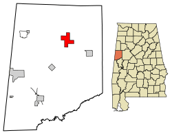
Location of Reform in Pickens County, Alabama
|
|
| Country | United States |
| State | Alabama |
| County | Pickens |
| Area | |
| • Total | 8.04 sq mi (20.82 km2) |
| • Land | 8.01 sq mi (20.74 km2) |
| • Water | 0.03 sq mi (0.07 km2) |
| Elevation | 240 ft (70 m) |
| Population
(2020)
|
|
| • Total | 1,520 |
| • Density | 189.81/sq mi (73.28/km2) |
| Time zone | UTC-6 (Central (CST)) |
| • Summer (DST) | UTC-5 (CDT) |
| ZIP code |
35481
|
| Area code(s) | 205, 659 |
| FIPS code | 01-64104 |
| GNIS feature ID | 0125544 |
Reform (/ˈriːfɔːrm/; REE-form) is a city in Pickens County, Alabama, United States. At the 2010 census the population was 1,702, down from 1,978 in 2000. It is located approximately halfway between Columbus, Mississippi and Tuscaloosa on U.S. Route 82.
History
Sparsely settled after statehood, Reform first received a post office in 1841. It wasn't incorporated until March 2, 1898, following the community getting train service via the Mobile and Ohio Railroad. According to tradition, the community was named from an incident when an evangelist paid the new settlement a visit, imploring the first settlers to "reform".
On January 24, 1940, Reform set the record for the highest recorded snow depth for Alabama at 22 inches (55.9 cm).
In May 1968, a mule train, part of the Southern Christian Leadership Conference sponsored Poor People's Campaign, stopped for two days in Reform before heading to Tuscaloosa, Alabama on its way to Washington, DC.
On August 31, 2017, the area was hit by an EF2 tornado. The tornado touched down near Reform and tracked through Pickens, Lamar, and Fayette counties. Significant damage was also caused in the nearby community of Palmetto.
Geography
Reform is located at 33°22′51″N 88°0′54″W / 33.38083°N 88.01500°W (33.380835, -88.015022).
The city is located in west central Alabama at the intersection of U.S. Route 82 and Alabama State Route 17. US 82 runs northwest to southeast through the city, leading southeast 8 mi (13 km) to Gordo and 31 mi (50 km) to Tuscaloosa, the largest city of over 100,000 people closest to the area. Columbus, Mississippi is 29 mi (47 km) to the northwest. AL 17 runs north to south, leading north 19 mi (31 km) to Millport and south 10 mi (16 km) to Carrollton, the Pickens County seat.
According to the U.S. Census Bureau, the city has a total area of 8.1 square miles (21 km2), of which 8.0 square miles (21 km2) is land and 0.04 square miles (0.10 km2) (0.37%) is water.
Demographics
| Historical population | |||
|---|---|---|---|
| Census | Pop. | %± | |
| 1900 | 198 | — | |
| 1910 | 550 | 177.8% | |
| 1920 | 1,069 | 94.4% | |
| 1930 | 898 | −16.0% | |
| 1940 | 885 | −1.4% | |
| 1950 | 1,141 | 28.9% | |
| 1960 | 1,241 | 8.8% | |
| 1970 | 1,893 | 52.5% | |
| 1980 | 2,245 | 18.6% | |
| 1990 | 2,105 | −6.2% | |
| 2000 | 1,978 | −6.0% | |
| 2010 | 1,702 | −14.0% | |
| 2020 | 1,520 | −10.7% | |
| U.S. Decennial Census 2013 Estimate |
|||
2020 census
| Race | Num. | Perc. |
|---|---|---|
| White (non-Hispanic) | 651 | 42.83% |
| Black or African American (non-Hispanic) | 782 | 51.45% |
| Other/Mixed | 54 | 3.55% |
| Hispanic or Latino | 33 | 2.17% |
As of the 2020 United States census, there were 1,520 people, 696 households, and 475 families residing in the town.
2010 census
As of the 2010 United States Census, there were 1,702 people living in the town. 50.6% were White, 48.2% African American, 0.1% Native American, 0.4% from some other race and 0.7% of two or more races. 0.9% were Hispanic or Latino of any race.
Education
Education in Reform is overseen and governed by the Pickens County Board of Education. Students of Reform and its surrounding areas are served by Reform Elementary School and Pickens County High School.
Notable people
- Tony Dixon, safety for the Dallas Cowboys
- Doug Elmore, punter for the Washington Redskins
- Andrew F. Fox, Member of US House of Representatives
- James L. Malone, head football coach at Northeast Louisiana State College, 1951–1953
- John Proctor, FBI agent instrumental in solving the 1964 case for the murders of Chaney, Goodman, and Schwerner
- Michael Williams, NFL tight end for the New England Patriots
See also
 In Spanish: Reform (Alabama) para niños

