Red Bank, Tennessee facts for kids
Quick facts for kids
Red Bank, Tennessee
|
|||
|---|---|---|---|

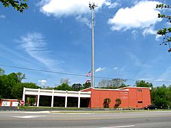
Red Bank City Hall
|
|||
|
|||

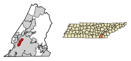
Location of Red Bank in Hamilton County, Tennessee
|
|||
| Country | United States | ||
| State | Tennessee | ||
| County | Hamilton | ||
| Incorporated | 1955 | ||
| Government | |||
| • Type | Council-Manager | ||
| Area | |||
| • Total | 6.56 sq mi (16.99 km2) | ||
| • Land | 6.56 sq mi (16.99 km2) | ||
| • Water | 0.00 sq mi (0.00 km2) | ||
| Elevation | 722 ft (220 m) | ||
| Population
(2020)
|
|||
| • Total | 11,899 | ||
| • Density | 1,814.43/sq mi (700.54/km2) | ||
| Time zone | UTC-5 (Eastern (EST)) | ||
| • Summer (DST) | UTC-4 (EDT) | ||
| ZIP code |
37415 (with some 37405 and 37434)
|
||
| Area code(s) | 423 | ||
| FIPS code | 47-61960 | ||
| GNIS feature ID | 1299035 | ||
Red Bank is a city in Hamilton County, Tennessee, United States. The population was 11,899 at the 2020 census. Red Bank is an enclave, being entirely surrounded by the city limits of Chattanooga. Red Bank is part of the Chattanooga metropolitan area.
Contents
History
Red Bank was originally known as "Pleasant Hill". When a post office was established in the community in 1881, however, it was asked to adopt a new name, since the name "Pleasant Hill" was already taken. The name "Red Bank" was chosen by the wife of the first postmaster, George Hartman. It was inspired by the red clay ridge that was visible from a window in her house. In 1955, the communities of Red Bank and White Oak incorporated as a single town called "Red Bank-White Oak". In 1966, the city voted to drop the "White Oak" for simplification purposes.
Geography
Red Bank is located at 35°6′37″N 85°17′49″W / 35.11028°N 85.29694°W (35.110372, -85.297048). The city lies at the base of the Cumberland Plateau in southwestern Hamilton County. It is bordered on all sides by the city of Chattanooga and is 5 miles (8 km) north of Chattanooga's downtown. Dayton Boulevard is the city's main thoroughfare, though U.S. Route 27 runs along the city's western edge.
According to the United States Census Bureau, Red Bank has a total area of 6.5 square miles (16.9 km2), all of it recorded as land. The city center follows the valley of Stringers Branch, a southwest-flowing tributary of the Tennessee River.
Demographics
| Historical population | |||
|---|---|---|---|
| Census | Pop. | %± | |
| 1960 | 10,777 | — | |
| 1970 | 12,715 | 18.0% | |
| 1980 | 13,129 | 3.3% | |
| 1990 | 12,322 | −6.1% | |
| 2000 | 12,418 | 0.8% | |
| 2010 | 11,651 | −6.2% | |
| 2020 | 11,899 | 2.1% | |
| Sources: | |||
2020 census
| Race | Number | Percentage |
|---|---|---|
| White (non-Hispanic) | 9,442 | 79.35% |
| Black or African American (non-Hispanic) | 789 | 6.63% |
| Native American | 18 | 0.15% |
| Asian | 138 | 1.16% |
| Pacific Islander | 2 | 0.02% |
| Other/Mixed | 589 | 4.95% |
| Hispanic or Latino | 921 | 7.74% |
As of the 2020 United States census, there were 11,899 people, 5,683 households, and 2,667 families residing in the city.
Education
Within the Red Bank city limits are Red Bank High School, Red Bank Junior High, and Alpine Crest Elementary School. Red Bank Elementary School, while one of Red Bank's zoned schools, is outside of the city limits in Chattanooga.
Natural Resources & Public Lands
- Stringer's Branch
- Stringer's Ridge
- White Oak Park & Dog Park
- Red Bank Community Center & Park
- Kids Corner Park
- Norma Cagle Ballfields
- Town Center Park
- Red Bank is designated as a "Bird Sanctuary"
- Red Bank is home to the Tennessee State Champion Virginia Pine discovered by Don McKenzie
Notable people
- Bill Dedman, Pulitzer Prize-winning journalist and author, raised in Red Bank
- Wendell Rawls, Jr., Pulitzer Prize-winning journalist and author, raised in Red Bank
- Kane Brown, Singer
- Emma Bell Miles, Writer, poet, and artist. Her works capture the essence of the natural world and the culture of southern Appalachia
- Tim Benford, former NFL wide receiver
- Keionta Davis, NFL defensive end
- Dorothy Montgomery, former professional baseball player in the All-American Girls Professional Baseball League
- Ronald L. Schlicher, diplomat and foreign service officer
See also
 In Spanish: Red Bank (Tennessee) para niños


