Rangitīkei River facts for kids
Quick facts for kids Rangitīkei River |
|
|---|---|

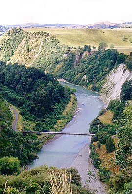
Rangitīkei River near Mangaweka
|
|

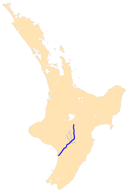
The Rangitīkei River system
|
|
| Native name | Rangitīkei |
| Country | New Zealand |
| Region | Manawatū-Whanganui |
| Physical characteristics | |
| Main source | Ngapuketurua Kaimanawa Ranges 1,480 metres (4,860 ft) 39°4′52″S 176°1′52″E / 39.08111°S 176.03111°E |
| River mouth | Tasman Sea Tangimoana Sea level 40°18′2″S 175°13′31″E / 40.30056°S 175.22528°E |
| Length | 253 kilometres (157 mi) |
| Basin features | |
| Basin size | 3,948 square kilometres (1,524 sq mi) |
| Tributaries |
|
The Rangitīkei River is one of New Zealand's longest rivers, 253 kilometres (157 mi) long.
Its headwaters are to the southeast of Lake Taupo in the Kaimanawa Ranges. It flows from the Central Plateau south past Taihape, Mangaweka, Hunterville, Marton, and Bulls, to the South Taranaki Bight at Tangimoana, 40 kilometres (25 mi) southeast of Wanganui. The river gives its name to the surrounding Rangitikei District.
In 1897 the river flooded and all the bridges over it (Vinegar Hill, Onepuhi, Kakariki railway bridge and Bulls) were damaged or destroyed. Port of Rangitikei, at the mouth of the river was also washed away and never rebuilt. Other notable floods were in 1882, 1917, 1936, 1958, 1965 and 2004. Until 1908 a ferry linked Tangimoana to Scotts Ferry. Onepuhi, or Onepuehu, bridge was shown on the 1941 map, but missing from the 1968 and later maps. Further decking for the 807 ft (246 m) long Onepuhi bridge was suggested in 1958.
The river is a popular leisure and recreation area for jetboating, white water rafting, kayaking and fishing, and includes public camp grounds along its banks, including Vinegar Hill, New Zealand. Its sheer vertical "paapa" (clay) cliffs (unique to this part of New Zealand) and deep canyons provide the perfect setting for adventure activities such as bungy jumps and flying fox rides. The cliffs, which display oxygen isotope stages, have been incised into the soft Quaternary, 2.6 to 1.7 million year old, marine sediments as the land has risen since the last ice age. The rise has left 19 terraces, which have been mapped.
Part of the river was used as the Anduin River in Peter Jackson's movie The Lord of the Rings: The Fellowship of the Ring.
Both rainbow and brown trout throughout the river system with fish in the upper reaches reaching trophy size (i.e. over 4.5 kg) with the average through the rest of the system being around 1.5 to 2 kg. Fish numbers are good throughout the system though there are fewer fish per kilometre in the upper reaches. This is made up for by the quality and size of the fish being larger in this section.
Images for kids
See also
 In Spanish: Río Rangitikei para niños


