Quay County, New Mexico facts for kids
Quick facts for kids
Quay County
|
|
|---|---|

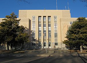
Quay County Courthouse in Tucumcari
|
|

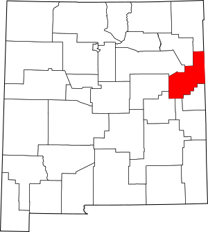
Location within the U.S. state of New Mexico
|
|
 New Mexico's location within the U.S. |
|
| Country | |
| State | |
| Founded | February 28, 1903 |
| Named for | Matthew Quay |
| Seat | Tucumcari |
| Largest city | Tucumcari |
| Area | |
| • Total | 2,882 sq mi (7,460 km2) |
| • Land | 2,874 sq mi (7,440 km2) |
| • Water | 7.2 sq mi (19 km2) 0.3%% |
| Population
(2020)
|
|
| • Total | 8,746 |
| • Density | 3.0347/sq mi (1.17170/km2) |
| Time zones | |
| Entire county (legally) | UTC−7 (Mountain) |
| • Summer (DST) | UTC−6 (MDT) |
| Nara Visa (unofficially) | UTC−6 (Central) |
| • Summer (DST) | UTC−5 (CDT) |
| Congressional district | 3rd |
Quay County (/ˈkweɪ/) is a county in the state of New Mexico. As of the 2020 U.S. census, the population was 8,746. Its county seat is Tucumcari. The county was named for Pennsylvania senator Matthew Quay, who supported statehood for New Mexico. Its eastern border is the Texas state line, approximately 103.04 degrees west longitude.
Contents
Geography
According to the U.S. Census Bureau, the county has a total area of 2,882 square miles (7,460 km2), of which 2,874 square miles (7,440 km2) is land and 7.2 square miles (19 km2) (0.3%) is water.
Adjacent counties
- Union County - north
- Harding County - northwest
- San Miguel County - west
- Guadalupe County - west
- De Baca County - southwest
- Roosevelt County - south
- Curry County - south
- Deaf Smith County, Texas - southeast
- Oldham County, Texas - east
- Hartley County, Texas - northeast
Demographics
| Historical population | |||
|---|---|---|---|
| Census | Pop. | %± | |
| 1910 | 14,912 | — | |
| 1920 | 10,444 | −30.0% | |
| 1930 | 10,828 | 3.7% | |
| 1940 | 12,111 | 11.8% | |
| 1950 | 13,971 | 15.4% | |
| 1960 | 12,279 | −12.1% | |
| 1970 | 10,903 | −11.2% | |
| 1980 | 10,577 | −3.0% | |
| 1990 | 10,823 | 2.3% | |
| 2000 | 10,155 | −6.2% | |
| 2010 | 9,041 | −11.0% | |
| 2020 | 8,746 | −3.3% | |
| U.S. Decennial Census 1790-1960 1900-1990 1990-2000 2010 |
|||
2010 census
As of the 2010 census, there were 9,041 people, 4,072 households, and 2,502 families living in the county. The population density was 3.1 inhabitants per square mile (1.2/km2). There were 5,569 housing units at an average density of 1.9 units per square mile (0.73 units/km2). The racial makeup of the county was 86.1% white, 1.2% American Indian, 1.1% black or African American, 1.0% Asian, 7.2% from other races, and 3.4% from two or more races. Those of Hispanic or Latino origin made up 42.4% of the population. In terms of ancestry, 11.4% were American, 10.7% were English, 10.5% were German, and 9.8% were Irish.
Of the 4,072 households, 26.4% had children under the age of 18 living with them, 43.5% were married couples living together, 12.7% had a female householder with no husband present, 38.6% were non-families, and 34.2% of all households were made up of individuals. The average household size was 2.21 and the average family size was 2.79. The median age was 45.6 years.
The median income for a household in the county was $28,773 and the median income for a family was $41,766. Males had a median income of $29,769 versus $32,462 for females. The per capita income for the county was $18,234. About 13.3% of families and 21.1% of the population were below the poverty line, including 30.7% of those under age 18 and 17.3% of those age 65 or over.
Communities
City
- Tucumcari (county seat)
Villages
Census-designated place
Other communities
Education
School districts include:
- Grady Municipal Schools
- House Municipal Schools
- Logan Municipal Schools
- Melrose Public Schools
- San Jon Municipal Schools
- Tucumcari Public Schools
See also
 In Spanish: Condado de Quay para niños

