Puy de Sancy facts for kids
Quick facts for kids Puy de Sancy |
|
|---|---|

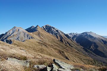
South face of Puy de Sancy viewed from Tour Carrée
|
|
| Highest point | |
| Elevation | 1,885 m (6,184 ft) |
| Prominence | 1,578 m (5,177 ft) |
| Parent peak | Monts Dore |
| Geography | |
|
Lua error in Module:Location_map at line 420: attempt to index field 'wikibase' (a nil value).
|
|
| Location | Puy-de-Dôme departement, France |
| State/Province | FR |
| Parent range | Massif Central |
| Geology | |
| Mountain type | Stratovolcano |
Puy de Sancy (Occitan: Puèi de la Crotz, "Mount of the Cross") is a French mountain, the highest mountain in the Massif Central. It is part of an old stratovolcano which has been inactive for about 250,000 years.
Puy de Sancy is in the Puy-de-Dôme departement in the Auvergne-Rhône-Alpes region. With an elevation of 1,885 m (6,184 ft) above sea level, it is the highest point of the department and of the region.
Contents
Name
The mountain was called during the 19th century as Puy de la Croix ("Mount of the Cross") because there was a big cross on the summit (the top of the mountain). That name is kept in the Occitan language.
Geography
Puy de Sancy is in the Monts Dore, a chain of volcanic mountains in the centre of the Massif Central and at about 35 km (22 mi) to the southwest of Clermont-Ferrand; it is within the borders of the Parc naturel régional des volcans d'Auvergne ("Regional Nature Park of the Auvergne Volcanoes").
Several small rivers (streams) have their sources on the sides of Puy de Sancy. In the valley to the north of the mountain are the sources of two streams called Dore and Dogne; at an altitude of 1,370 m (4,495 ft), both streams are joined to form the Dordogne river.
Ski resorts
There are three ski stations (places where people go to practice skiing) on the slopes of Puy de Sancy: Super-Besse and Mont-Dore (together they are called the Grand Sancy) and Chastreix-Sancy.
See also
 In Spanish: Pico de Sancy para niños


