Province of Ravenna facts for kids
Quick facts for kids
Province of Ravenna
|
||
|---|---|---|

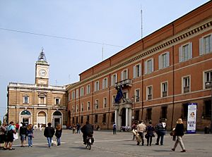
Piazza del Popolo, Ravenna
|
||
|
||

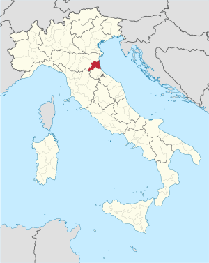
Map with the province of Ravenna, in red, in Italy
|
||
| Country | ||
| Region | Emilia-Romagna | |
| Capital | Ravenna | |
| Comuni | 18 | |
| Area | ||
| • Total | 1,859.44 km2 (717.93 sq mi) | |
| Population
(January 2017)
|
||
| • Total | 391,414 | |
| • Density | 210.5010/km2 (545.1951/sq mi) | |
| Time zone | UTC+1 (CET) | |
| • Summer (DST) | UTC+2 (CEST) | |
| Postal code |
48010-48015, 48017, 48018, 48020, 48022, 48024-48027, 48100
|
|
| Telephone prefix | 0544, 0545, 0546 | |
| ISO 3166 code | IT-RA | |
| Vehicle registration | RA | |
| ISTAT | 039 | |
| Website | Official website: http://www.provincia.ra.it/ | |
The province of Ravenna (Italian: provincia di Ravenna) is a province in the Emilia-Romagna region in Northeast Italy, on the Adriatic Sea. Its capital is the city of Ravenna.
Contents
History
The province was created in 1859.
Geography
The province of Ravenna is in the eastern part of the Emilia-Romagna region along the Adriatic Sea.
It has an area of 1,859.44 km2 (717.93 sq mi). The provincial capital, the city of Ravenna, is at about 8 km (5.0 mi) from the Adriatic Sea and at about 68 km (42 mi) southeast of Bologna, the capital of the region.
The province borders the province of Ferrara to the north, the Metropolitan City of Bologna to the west, the province of Florence in Tuscany to the southwest and the province of Forlì-Cesena to the south.
 |
Ferrara (province) |  |
||
| Bologna (province) | Adriatic Sea | |||
| Florence (province) (Tuscany) |
Forlì-Cesena (province) |
The highest point in the province is Monte Macchia dei Cani (44°09′28″N 11°31′30″E / 44.15778°N 11.52500°E); it is 966 m (3,169 ft) high.
The main rivers in the province are:
- Reno - 211 km
- Lamone - 90 km
- Senio - 92 km
- Uniti - 12 km
- Montone - 140 km
- Bidente-Ronco - 135 km
- Bevano - 33 km
- Savio - 126 km
Climate
The area in Punta Marina Terme (part of the Ravenna Commune on the coast), at an altitude of about 1 m (3.3 ft), is characterized by a climate with relatively high temperatures and precipitation throughout the year. The Köppen climate classification type for the climate at Punta Marina Terme is a "Humid Subtropical Climate" and of the subtype "Cfa".
The average amount of precipitation for the year in Punta Marina Terme is 604.5 mm (23.8 in). The month with the most precipitation on average is November with 68.6 mm (2.7 in) of precipitation. The month with the least precipitation on average is February with an average of 35.6 mm (1.4 in). There is an average of 71.0 days of precipitation, with the most precipitation days in November with 7.4 days and the least precipitation days in July with 4.4 days.
The average temperature for the year in Punta Marina Terme is 13.4 °C (56.1 °F). The warmest month, on average, is July with an average temperature of 23.2 °C (73.8 °F). The coolest month on average is January, with an average temperature of 2.8 °C (37.0 °F).
Population
There are 391,414 persons living in the province (January 2017), for a population density of 210.5 inhabitants/km².
Evolution of the population in the province

Administration
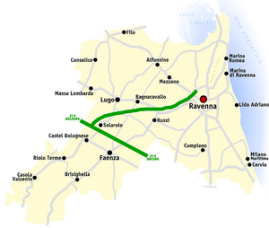
The following table shows the 18 comuni with the population, and the area and altitude.
| No. | Comune | Population (2017) |
Area (km²) |
Density | Altitude |
|---|---|---|---|---|---|
| 1. | Alfonsine | 11,993 | 106.79 | 112.3 | 6 |
| 2. | Bagnacavallo | 16,686 | 79.58 | 209.7 | 11 |
| 3. | Bagnara di Romagna | 2,432 | 9.96 | 244.2 | 22 |
| 4. | Brisighella | 7,629 | 194.33 | 39.3 | 115 |
| 5. | Casola Valsenio | 2,650 | 84.42 | 31.4 | 195 |
| 6. | Castel Bolognese | 9,594 | 32.37 | 296.4 | 42 |
| 7. | Cervia | 28,794 | 82.27 | 350.0 | 5 |
| 8. | Conselice | 9,783 | 60.20 | 162.5 | 6 |
| 9. | Cotignola | 7,487 | 35.14 | 213.1 | 19 |
| 10. | Faenza | 58,836 | 215.76 | 272.7 | 35 |
| 11. | Fusignano | 8,155 | 24.55 | 332.2 | 9 |
| 12. | Lugo | 32,396 | 117.06 | 276.7 | 12 |
| 13. | Massa Lombarda | 10,578 | 37.25 | 284.0 | 13 |
| 14. | Ravenna | 159,057 | 653.82 | 243.3 | 4 |
| 15. | Riolo Terme | 5,683 | 44.26 | 128.4 | 98 |
| 16. | Russi | 12,308 | 46.26 | 266.1 | 13 |
| 17. | Sant'Agata sul Santerno | 2,880 | 9.37 | 307.4 | 14 |
| 18. | Solarolo | 4,473 | 26.04 | 171.8 | 25 |
See also
 In Spanish: Provincia de Rávena para niños


