
Promise Island facts for kids
 |
|

Promise Island (Nannuyuma)
Location in Nunavut

Promise Island (Nannuyuma)
Location in Canada
|
|
| Geography | |
|---|---|
| Location | Hudson Bay |
| Coordinates | 63°21′30″N 90°32′00″W / 63.35833°N 90.53333°W |
| Highest elevation | 300 ft (90 m) |
| Administration | |
| Nunavut | Nunavut |
| Region | Kivalliq |
| Demographics | |
| Population | Uninhabited |
Promise Island (Inuktitut: Nannuyuma; meaning: "polar bear") is located near the western shore of Hudson Bay. It is barely a square kilometre in area and rises 300 ft (91 m) in elevation on its northern side. It is located about 9 km (5.6 mi) from the community of Chesterfield Inlet, Nunavut, Canada, and is part of a loose chain of small islands running along the coast, including the Wag Islands and Pitsiulartok (Fairway Island).
The island is home to a wide range of wildlife, including the Arctic fox (alopex lagopus innuitus), the harbour seal (phoca hispida), the polar bear, the brown lemming (lemmus t. trimucronatus), the barren-ground caribou (rangifer arcticus), and the red phalarope.
-
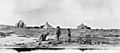
"Natives, Promise Island" Photo c. 1920-25 by Hudson's Bay Company employee Capt. George Cleveland of the motor schooner Fort Chesterfield.

