Pottsville, Arkansas facts for kids
Quick facts for kids
Pottsville, Arkansas
|
|
|---|---|

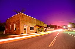
"Downtown" Pottsville
|
|

Location of Pottsville in Pope County, Arkansas.
|
|
| Country | United States |
| State | Arkansas |
| County | Pope |
| Area | |
| • Total | 13.56 sq mi (35.11 km2) |
| • Land | 13.53 sq mi (35.05 km2) |
| • Water | 0.02 sq mi (0.06 km2) |
| Elevation | 387 ft (118 m) |
| Population
(2020)
|
|
| • Total | 3,140 |
| • Density | 232.04/sq mi (89.59/km2) |
| Time zone | UTC-6 (Central (CST)) |
| • Summer (DST) | UTC-5 (CDT) |
| ZIP code |
72858
|
| Area code(s) | 479 |
| FIPS code | 05-56990 |
| GNIS feature ID | 2404563 |
Pottsville is a city in Pope County, Arkansas, United States. As of the 2020 census the population was 3,140. It is part of the Russellville Micropolitan Statistical Area.
Contents
Geography
Pottsville is surrounded by Russellville to the west, Atkins to the east, and Crow Mountain to the north.
According to the United States Census Bureau, the town has a total area of 7.5 square miles (19 km2), of which 7.5 square miles (19 km2) is land and 0.04 square miles (0.10 km2) (0.27%) is water.
Demographics
| Historical population | |||
|---|---|---|---|
| Census | Pop. | %± | |
| 1900 | 192 | — | |
| 1910 | 205 | 6.8% | |
| 1920 | 275 | 34.1% | |
| 1930 | 293 | 6.5% | |
| 1940 | 308 | 5.1% | |
| 1950 | 224 | −27.3% | |
| 1960 | 250 | 11.6% | |
| 1970 | 411 | 64.4% | |
| 1980 | 564 | 37.2% | |
| 1990 | 984 | 74.5% | |
| 2000 | 1,271 | 29.2% | |
| 2010 | 2,838 | 123.3% | |
| 2020 | 3,140 | 10.6% | |
| U.S. Decennial Census | |||
2020 census
| Race | Number | Percentage |
|---|---|---|
| White (non-Hispanic) | 2,610 | 83.12% |
| Black or African American (non-Hispanic) | 18 | 0.57% |
| Native American | 26 | 0.83% |
| Asian | 30 | 0.96% |
| Other/Mixed | 149 | 4.75% |
| Hispanic or Latino | 307 | 9.78% |
As of the 2020 United States census, there were 3,140 people, 1,031 households, and 840 families residing in the city.
See also
 In Spanish: Pottsville (Arkansas) para niños

All content from Kiddle encyclopedia articles (including the article images and facts) can be freely used under Attribution-ShareAlike license, unless stated otherwise. Cite this article:
Pottsville, Arkansas Facts for Kids. Kiddle Encyclopedia.
