Potrero Hills (Solano County, California) facts for kids
Quick facts for kids Potrero Hills |
|
|---|---|
| Highest point | |
| Elevation | 107 m (351 ft) |
| Geography | |
| Country | United States |
| State | California |
| Region | Sacramento–San Joaquin River Delta |
| District | Solano County |
| Range coordinates | 38°12′17.693″N 121°58′15.869″W / 38.20491472°N 121.97107472°W |
| Topo map | USGS Denverton |
| Geology | |
| Type of rock | California Coast Ranges |
The Potrero Hills are a low mountain range in the Sacramento–San Joaquin River Delta area of southern Solano County, California.
Geography
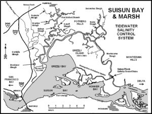
The range is located in the southwestern Sacramento Valley, northeast of Suisun Bay, and southeast of the city of Fairfield. It is part of the Northern Inner Coast Ranges group in the California Coast Ranges System.
The Rush Ranch Open Space Preserve unit of the San Francisco Bay National Estuarine Research Reserve is located on Suisun Bay at the western side of the Potrero Hills.

Map of Suisun Bay area, with Potrero Hills in upper center.

All content from Kiddle encyclopedia articles (including the article images and facts) can be freely used under Attribution-ShareAlike license, unless stated otherwise. Cite this article:
Potrero Hills (Solano County, California) Facts for Kids. Kiddle Encyclopedia.

