Polk County, Arkansas facts for kids
Quick facts for kids
Polk County
|
|
|---|---|

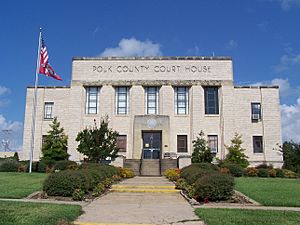
Polk County Courthouse in Mena
|
|

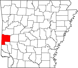
Location within the U.S. state of Arkansas
|
|
 Arkansas's location within the U.S. |
|
| Country | |
| State | |
| Founded | November 30, 1844 |
| Named for | James K. Polk |
| Seat | Mena |
| Largest city | Mena |
| Area | |
| • Total | 862 sq mi (2,230 km2) |
| • Land | 858 sq mi (2,220 km2) |
| • Water | 4.8 sq mi (12 km2) 0.6%% |
| Population
(2020)
|
|
| • Total | 19,221 |
| • Estimate
(2023)
|
19,436 |
| • Density | 22.298/sq mi (8.609/km2) |
| Time zone | UTC−6 (Central) |
| • Summer (DST) | UTC−5 (CDT) |
| Congressional district | 4th |
Polk County is a county located in the U.S. state of Arkansas. As of the 2020 census, the population was 19,221. The county seat is Mena. Polk County is Arkansas's 48th county, formed on November 30, 1844; it was named for James K. Polk, 11th President of the United States.
Contents
Wet County
Formerly an alcohol prohibition or dry county. However, following a historic mid-term election, Polk County is now a wet county.
Geography
According to the U.S. Census Bureau, the county has a total area of 862 square miles (2,230 km2), of which 858 square miles (2,220 km2) is land and 4.8 square miles (12 km2) (0.6%) is water.
Major highways
 Future Interstate 49
 U.S. Highway 59
 U.S. Highway 71
 U.S. Highway 270
 U.S. Highway 278
 Highway 4
 Highway 8
 Highway 84
 Highway 88
Transit
- Jefferson Lines
Adjacent counties
- Scott County (north)
- Montgomery County (east)
- Pike County (southeast)
- Howard County (southeast)
- Sevier County (south)
- McCurtain County, Oklahoma (southwest)
- Le Flore County, Oklahoma (northwest)
National protected area
- Ouachita National Forest (part)
Demographics
| Historical population | |||
|---|---|---|---|
| Census | Pop. | %± | |
| 1850 | 1,263 | — | |
| 1860 | 4,262 | 237.5% | |
| 1870 | 3,376 | −20.8% | |
| 1880 | 5,857 | 73.5% | |
| 1890 | 9,283 | 58.5% | |
| 1900 | 18,352 | 97.7% | |
| 1910 | 17,216 | −6.2% | |
| 1920 | 16,412 | −4.7% | |
| 1930 | 14,857 | −9.5% | |
| 1940 | 15,832 | 6.6% | |
| 1950 | 14,182 | −10.4% | |
| 1960 | 11,981 | −15.5% | |
| 1970 | 13,297 | 11.0% | |
| 1980 | 17,007 | 27.9% | |
| 1990 | 17,347 | 2.0% | |
| 2000 | 20,229 | 16.6% | |
| 2010 | 20,662 | 2.1% | |
| 2020 | 19,221 | −7.0% | |
| 2023 (est.) | 19,436 | −5.9% | |
| U.S. Decennial Census 1790–1960 1900–1990 1990–2000 2010 |
|||
2020 census
| Race | Number | Percentage |
|---|---|---|
| White (non-Hispanic) | 16,092 | 83.72% |
| Black or African American (non-Hispanic) | 39 | 0.2% |
| Native American | 335 | 1.74% |
| Asian | 100 | 0.52% |
| Pacific Islander | 9 | 0.05% |
| Other/Mixed | 1,368 | 7.12% |
| Hispanic or Latino | 1,278 | 6.65% |
As of the 2020 United States census, there were 19,221 people, 8,243 households, and 5,672 families residing in the county.
Communities
Cities
Towns
Census-designated places
Other unincorporated communities
Townships
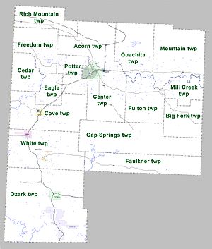
Townships in Arkansas are the divisions of a county. Each township includes unincorporated areas; some may have incorporated cities or towns within part of their boundaries. Arkansas townships have limited purposes in modern times. However, the United States Census does list Arkansas population based on townships (sometimes referred to as "county subdivisions" or "minor civil divisions"). Townships are also of value for historical purposes in terms of genealogical research. Each town or city is within one or more townships in an Arkansas county based on census maps and publications. The townships of Polk County are listed below; listed in parentheses are the cities, towns, and/or census-designated places that are fully or partially inside the township.
See also
 In Spanish: Condado de Polk (Arkansas) para niños


