Pohatcong Township, New Jersey facts for kids
Quick facts for kids
Pohatcong Township, New Jersey
|
||
|---|---|---|
|
Township
|
||

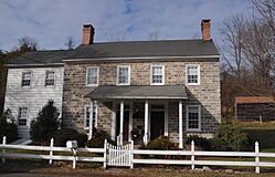
Springtown Stagecoach Inn, listed on the National Register of Historic Places
|
||
|
||

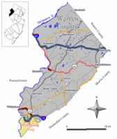
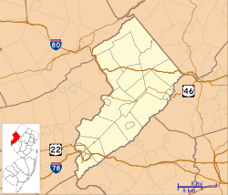
Location of Pohatcong Township in Warren County highlighted in yellow (right). Inset map: Location of Warren County in New Jersey highlighted in black (left).
|
||

Census Bureau map of Pohatcong Township, New Jersey
|
||
| Country | ||
| State | ||
| County | ||
| Incorporated | January 1, 1882 | |
| Government | ||
| • Type | Faulkner Act | |
| • Body | Township Council | |
| Area | ||
| • Total | 13.76 sq mi (35.63 km2) | |
| • Land | 13.37 sq mi (34.63 km2) | |
| • Water | 0.39 sq mi (1.00 km2) 2.81% | |
| Area rank | 179th of 565 in state 13th of 22 in county |
|
| Elevation | 253 ft (77 m) | |
| Population
(2020)
|
||
| • Total | 3,241 | |
| • Estimate
(2023)
|
3,276 | |
| • Rank | 439th of 565 in state 12th of 22 in county |
|
| • Density | 242.4/sq mi (93.6/km2) | |
| • Density rank | 492nd of 565 in state 13th of 22 in county |
|
| Time zone | UTC−05:00 (Eastern (EST)) | |
| • Summer (DST) | UTC−04:00 (Eastern (EDT)) | |
| ZIP Code | ||
| Area code | 908 | |
| FIPS code | 34-59820 | |
| GNIS feature ID | 882254 | |
| School district | Phillipsburg School District | |
Pohatcong Township is a township in Warren County, in the U.S. state of New Jersey. As of the 2020 United States census, the township's population was 3,241, a decrease of 98 (−2.9%) from the 2010 census count of 3,339, which in turn reflected a decline of 77 (−2.3%) from the 3,416 counted in the 2000 census.
The name Pohatcong is thought to be derived from the Lenni Lenape Native American term meaning "stream between split hills".
Contents
History
Pohatcong Township was officially established in 1881. On March 24, 1881, Chapter 145 of the Acts of the New Jersey General Assembly was published defining and creating Pohatcong Township. The act to form Pohatcong had been introduced by Assemblyman William Fritts and, once law, was to take effect January 1 of the following year. Pohatcong was incorporated on January 1, 1882. It was divided off of Greenwich Township. Pohatcong township's name comes from Lenape Native Americans, who called the area "split hills stream outlet". The industrialized center of the township was separated to form Alpha borough, on April 27, 1911.
Geography
According to the U.S. Census Bureau, the township had a total area of 13.76 square miles (35.63 km2), including 13.37 square miles (34.63 km2) of land and 0.39 square miles (1.00 km2) of water (2.81%).
Finesville (with a 2010 Census population of 175) and Upper Pohatcong (2010 population of 1,781) are unincorporated communities and census-designated places (CDPs) located within the township. Other unincorporated communities, localities and place names located partially or completely within the township include Carpentersville, Hughesville, Huntington, Kennedys, Riegelsville, Springtown, Warren and Warren Glen.
Pohatcong Township borders the municipalities of Greenwich Township, Lopatcong Township and Phillipsburg in Warren County; and Bethlehem Township, Bloomsbury and Holland Township in Hunterdon County. The borough of Alpha is completely surrounded by Pohatcong Township, making it part of 21 pairs of "doughnut towns" in the state, where one municipality entirely surrounds another.
Demographics
| Historical population | |||
|---|---|---|---|
| Census | Pop. | %± | |
| 1890 | 1,483 | — | |
| 1900 | 2,215 | 49.4% | |
| 1910 | 3,202 | 44.6% | |
| 1920 | 1,559 | * | −51.3% |
| 1930 | 1,974 | 26.6% | |
| 1940 | 2,029 | 2.8% | |
| 1950 | 2,540 | 25.2% | |
| 1960 | 3,543 | 39.5% | |
| 1970 | 3,924 | 10.8% | |
| 1980 | 3,856 | −1.7% | |
| 1990 | 3,591 | −6.9% | |
| 2000 | 3,416 | −4.9% | |
| 2010 | 3,339 | −2.3% | |
| 2020 | 3,241 | −2.9% | |
| 2023 (est.) | 3,276 | −1.9% | |
| Population sources: 1890–1920 1890 1890–1910 1910–1930 1940–2000 2000 2010 2020 * = Lost territory in previous decade |
|||
The township's economic data (as is all of Warren County) is calculated by the US Census Bureau as part of the Lehigh Valley / Allentown-Bethlehem-Easton, PA-NJ Metropolitan Statistical Area.
2010 census
The 2010 United States census counted 3,339 people, 1,310 households, and 942 families in the township. The population density was 250.0 per square mile (96.5/km2). There were 1,420 housing units at an average density of 106.3 per square mile (41.0/km2). The racial makeup was 95.24% (3,180) White, 1.59% (53) Black or African American, 0.03% (1) Native American, 0.90% (30) Asian, 0.00% (0) Pacific Islander, 0.69% (23) from other races, and 1.56% (52) from two or more races. Hispanic or Latino of any race were 3.47% (116) of the population.
Of the 1,310 households, 29.8% had children under the age of 18; 58.8% were married couples living together; 8.6% had a female householder with no husband present and 28.1% were non-families. Of all households, 23.4% were made up of individuals and 10.8% had someone living alone who was 65 years of age or older. The average household size was 2.55 and the average family size was 3.01.
22.6% of the population were under the age of 18, 6.6% from 18 to 24, 24.3% from 25 to 44, 31.6% from 45 to 64, and 14.9% who were 65 years of age or older. The median age was 42.8 years. For every 100 females, the population had 100.2 males. For every 100 females ages 18 and older there were 97.3 males. The Census Bureau's 2006–2010 American Community Survey showed that (in 2010 inflation-adjusted dollars) median household income was $84,318 (with a margin of error of +/− $14,047) and the median family income was $95,982 (+/− $2,028). Males had a median income of $56,705 (+/− $13,134) versus $35,481 (+/− $1,974) for females. The per capita income for the borough was $34,781 (+/− $7,346). About 3.9% of families and 4.9% of the population were below the poverty line, including 2.2% of those under age 18 and 3.9% of those age 65 or over.
Economy
The Phillipsburg Mall is located on the border of Pohatcong and Lopatcong Township. 43 acres (17 ha) of the mall is located in Pohatcong, with the portion of the property in the township being assessed for $39.8 million, one of the highest valuations in the municipality.
Education
The Pohatcong Township School District serves students in pre-kindergarten through eighth grade at Pohatcong Township Elementary School. As of the 2018–19 school year, the district, comprised of one school, had an enrollment of 304 students and 30.3 classroom teachers (on an FTE basis), for a student–teacher ratio of 10.0:1.
Public school students in ninth through twelfth grades attend Phillipsburg High School in Phillipsburg, which serves students from the Town of Phillipsburg as part of a sending/receiving relationship with the Phillipsburg School District. The high school also serves students from four other sending communities: Alpha, Bloomsbury (in Hunterdon County), Greenwich Township and Lopatcong Township. As of the 2018–19 school year, the high school had an enrollment of 1,650 students and 126.5 classroom teachers (on an FTE basis), for a student–teacher ratio of 13.0:1.
Students from the township and from all of Warren County are eligible to attend Ridge and Valley Charter School in Frelinghuysen Township (for grades K–8) or Warren County Technical School in Washington borough (for 9–12), with special education services provided by local districts supplemented throughout the county by the Warren County Special Services School District in Oxford Township (for PreK–12).
Transportation
Roads and highways
As of May 2010[update], the township had a total of 54.70 miles (88.03 km) of roadways, of which 36.13 miles (58.15 km) were maintained by the municipality, 12.81 miles (20.62 km) by Warren County, 3.20 miles (5.15 km) by the New Jersey Department of Transportation and 2.56 miles (4.12 km) by the Delaware River Joint Toll Bridge Commission.
Interstate 78 is the most significant highway in Pohatcong. It passes through in the central region of the township. U.S. Route 22 runs along the eastern border before running concurrent with I-78. Route 122 passes through the northern portions of the township. The most significant county road in the township is CR 519.
The Riegelsville Bridge is a suspension bridge crossing the Delaware River connecting Pohatcong to Riegelsville, Pennsylvania, that is owned and operated by the Delaware River Joint Toll Bridge Commission. The current bridge on the site opened in 1904.
Public transportation
Trans-Bridge Lines operates the New Jersey Transit 890 and 891 bus routes, which connect Pohatcong Township with Easton, Pennsylvania.
Rail- the Lehigh Line
The Norfolk Southern Railway's Lehigh Line (formerly the mainline of the Lehigh Valley Railroad), runs through Pohatcong Township on its way to Phillipsburg, New Jersey.
Points of interest
The George Hunt House was added to the National Register of Historic Places in 1979 for its significance in architecture.
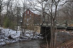
The Hixson–Skinner Mill Complex, also known as Cole's Grist Mill Complex, near Springtown, was added to the NRHP in 1982 for its significance in commerce and industry.
The Finesville–Seigletown Historic District was added to the NRHP in 2010 for its significance in architecture, engineering, and industry.
The Hixson–Mixsell House, also known as the Springtown Stagecoach Inn, was added to the NRHP in 2014 for its significance in architecture.
Wineries


