Plymouth County, Iowa facts for kids
Quick facts for kids
Plymouth County
|
|
|---|---|

|
|

Location within the U.S. state of Iowa
|
|
 Iowa's location within the U.S. |
|
| Country | |
| State | |
| Founded | January 15, 1851 |
| Named for | Plymouth, Massachusetts |
| Seat | Le Mars |
| Largest city | Le Mars |
| Area | |
| • Total | 864 sq mi (2,240 km2) |
| • Land | 863 sq mi (2,240 km2) |
| • Water | 0.8 sq mi (2 km2) 0.1% |
| Population
(2020)
|
|
| • Total | 25,698 |
| • Density | 29.743/sq mi (11.484/km2) |
| Time zone | UTC−6 (Central) |
| • Summer (DST) | UTC−5 (CDT) |
| Congressional district | 4th |
Plymouth County is a county located in the U.S. state of Iowa. As of the 2020 census, the population was 25,698. The county seat is Le Mars. Plymouth County was named after Plymouth, Massachusetts.
Plymouth County is part of the Sioux City, IA-NE-SD Metropolitan Statistical Area.
Contents
History
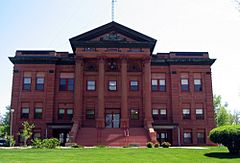
Plymouth County was formed on January 15, 1851. Settlement began in the county in 1856. In October 1859, the first courthouse was built in Melbourne, formerly located in the southeast quarter of section 34, Plymouth Township, about five to six miles due south of Merrill. The first public school opened its doors there with 32 pupils. In 1872 the county seat was moved to Le Mars and a courthouse and jail were built there in 1873. The present Plymouth County Courthouse was built in 1900 of red sandstone.
During the Great Depression, farmers in the county organized the Farmers Holiday Group, to keep farm products off the market until the desired price was met. A radical group among them abducted Judge Bradley from his court chamber and threatened to hang him in the front of the courthouse. Bradley was freed, but the governor ordered the national guard to Plymouth County and declared a state of emergency, which effectively ended the group.
Geography
According to the U.S. Census Bureau, the county has a total area of 864 square miles (2,240 km2), of which 863 square miles (2,240 km2) is land and 0.8 square miles (2.1 km2) (0.1%) is water. It is the fourth-largest county by area in Iowa.
Adjacent counties
- Sioux County (north)
- Cherokee County (east)
- Woodbury County (south)
- Union County, South Dakota (west)
Transportation
Major highways
Airport
Le Mars Municipal Airport is located in Plymouth County, two nautical miles (3.7 km) southwest of the central business district of Le Mars.
Demographics
| Historical population | |||
|---|---|---|---|
| Census | Pop. | %± | |
| 1860 | 148 | — | |
| 1870 | 2,199 | 1,385.8% | |
| 1880 | 8,566 | 289.5% | |
| 1890 | 19,568 | 128.4% | |
| 1900 | 22,209 | 13.5% | |
| 1910 | 23,129 | 4.1% | |
| 1920 | 23,584 | 2.0% | |
| 1930 | 24,159 | 2.4% | |
| 1940 | 23,502 | −2.7% | |
| 1950 | 23,252 | −1.1% | |
| 1960 | 23,906 | 2.8% | |
| 1970 | 24,322 | 1.7% | |
| 1980 | 24,743 | 1.7% | |
| 1990 | 23,388 | −5.5% | |
| 2000 | 24,849 | 6.2% | |
| 2010 | 24,986 | 0.6% | |
| 2020 | 25,698 | 2.8% | |
| 2023 (est.) | 25,722 | 2.9% | |
| U.S. Decennial Census 1790-1960 1900-1990 1990-2000 2010-2018 |
|||
2020 census

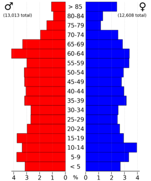
The 2020 census recorded a population of 25,698 in the county, with a population density of 29.7132/sq mi (11.4723/km2). 95.81% of the population reported being of one race. There were 10,818 housing units, of which 10,171 were occupied.
| Race | Num. | Perc. |
|---|---|---|
| White (NH) | 22,941 | 89.3% |
| Black or African American (NH) | 354 | 1.4% |
| Native American (NH) | 48 | 0.2% |
| Asian (NH) | 111 | 0.43% |
| Pacific Islander (NH) | 117 | 0.5% |
| Other/Mixed (NH) | 631 | 2.5% |
| Hispanic or Latino | 1,496 | 6% |
2010 census
The 2010 census recorded a population of 24,986 in the county, with a population density of 28.9337/sq mi (11.1714/km2). There were 10,550 housing units, of which 9,875 were occupied.
Points of interest
The Pappas Telecasting Tower, with a height of 603.5 metres (1,980 ft), is one of the tallest masts in the world.
Notable people
- William G. Kirchner, Minnesota state legislator and banker
- Ralph Klemme, Iowa state legislator and farmer
- Jim Nicholson, Former Secretary of Veterans Affairs, Republican National Chairman and U.S. Ambassador to the Vatican
- Johnny Niggeling, Major league baseball pitcher
- Paul Rust, actor and comedian
- Thomas Starzl, innovator in organ transplant surgery
- Isaac S. Struble, Congressman (1883–1891) after whom Struble is named
- William Garner Waddel, South Dakota State Senator
Communities
Cities
Unincorporated communities
- Adaville
- Brookdale
- Crathorne
- Ellendale
- James
- Mammen
- Melbourne
- Millnerville
- Neptune
- O'Leary
- Potosia
- Ruble
- Seney
- Union Center
- West Le Mars
- Wren
- Yeomans
Population ranking
The population ranking of the following table is based on the 2020 census of Plymouth County.
† county seat
| Rank | City/Town/etc. | Municipal type | Population (2020 Census) |
|---|---|---|---|
| 1 | † Le Mars | City | 10,571 |
| 2 | Remsen | City | 1,678 |
| 3 | Akron | City | 1,558 |
| 4 | Kingsley | City | 1,396 |
| 5 | Hinton | City | 935 |
| 6 | Merrill | City | 717 |
| 7 | Brunsville | City | 129 |
| 8 | Westfield | City | 123 |
| 9 | Oyens | City | 92 |
| 10 | Craig | City | 79 |
| 11 | Struble | City | 67 |
| 12 | Sioux City (almost entirely in Woodbury County) | City | 6 (85,797 total) |
See also
 In Spanish: Condado de Plymouth (Iowa) para niños


