Pittsville, Wisconsin facts for kids
Quick facts for kids
Pittsville, Wisconsin
|
|
|---|---|

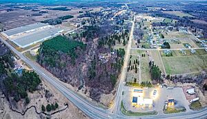
Wis-73 and Wis-80 junction on the north of town
|
|

Location of Pittsville in Wood County, Wisconsin.
|
|
| Country | |
| State | |
| County | Wood |
| Incorporated | March 30, 1887 |
| Area | |
| • Total | 2.00 sq mi (5.18 km2) |
| • Land | 1.99 sq mi (5.15 km2) |
| • Water | 0.01 sq mi (0.03 km2) |
| Elevation | 1,033 ft (315 m) |
| Population
(2010)
|
|
| • Total | 874 |
| • Estimate
(2019)
|
824 |
| • Density | 414.07/sq mi (159.85/km2) |
| Time zone | UTC-6 (Central (CST)) |
| • Summer (DST) | UTC-5 (CDT) |
| Zip code |
54466
|
| Area code(s) | 715 & 534 |
| FIPS code | 55-63100 |
| GNIS feature ID | 1571567 |
Pittsville is a city in Wood County, Wisconsin, United States. Located in a rural part of the county, Pittsville is surrounded by parks and public land, including; North Wood County Park and Campground, Powers Bluff, Dexter County Park and Campground, Sherwood County Park and Campground, Wood County Forest, Sandhill State Wildlife Area, and Black River State Forest. The population was 874 at the 2010 census and was 813 at the 2020 census.
History
Pittsville was platted in 1883, and named after Oliver W. Pitts, the proprietor of a local sawmill.
Geography
Pittsville is located at 44°26′25″N 90°7′42″W / 44.44028°N 90.12833°W (44.440409, -90.128249).
According to the United States Census Bureau, the city has a total area of 1.98 square miles (5.13 km2), of which, 1.97 square miles (5.10 km2) is land and 0.01 square miles (0.03 km2) is water.
Demographics
| Historical population | |||
|---|---|---|---|
| Census | Pop. | %± | |
| 1880 | 163 | — | |
| 1890 | 653 | 300.6% | |
| 1900 | 634 | −2.9% | |
| 1910 | 450 | −29.0% | |
| 1920 | 504 | 12.0% | |
| 1930 | 508 | 0.8% | |
| 1940 | 556 | 9.4% | |
| 1950 | 636 | 14.4% | |
| 1960 | 661 | 3.9% | |
| 1970 | 708 | 7.1% | |
| 1980 | 810 | 14.4% | |
| 1990 | 838 | 3.5% | |
| 2000 | 866 | 3.3% | |
| 2010 | 874 | 0.9% | |
| 2019 (est.) | 824 | −5.7% | |
| U.S. Decennial Census | |||
2010 census
As of the census of 2010, there were 874 people, 338 households, and 238 families living in the city. The population density was 443.7 inhabitants per square mile (171.3/km2). There were 378 housing units at an average density of 191.9 per square mile (74.1/km2). The racial makeup of the city was 97.9% White, 0.3% Native American, 0.8% Asian, and 0.9% from two or more races. Hispanic or Latino of any race were 0.8% of the population.
There were 338 households, of which 35.2% had children under the age of 18 living with them, 55.0% were married couples living together, 10.7% had a female householder with no husband present, 4.7% had a male householder with no wife present, and 29.6% were non-families. 25.4% of all households were made up of individuals, and 11.3% had someone living alone who was 65 years of age or older. The average household size was 2.55 and the average family size was 3.03.
The median age in the city was 36 years. 27.5% of residents were under the age of 18; 7.2% were between the ages of 18 and 24; 26% were from 25 to 44; 24.9% were from 45 to 64; and 14.5% were 65 years of age or older. The gender makeup of the city was 50.0% male and 50.0% female.
Notable people
- Red Blanchard, country musician
- Amos E. Germer, Wisconsin legislator and lawyer
- MaryAnn Lippert, Wisconsin legislator and educator
Education
The city is also home to the Pittsville School District, which has a school population of about 600 students.
See also
 In Spanish: Pittsville (Wisconsin) para niños


