Piscataquis County, Maine facts for kids
Quick facts for kids
Piscataquis County
|
|
|---|---|

|
|

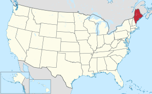
Location within the U.S. state of Maine
|
|
 Maine's location within the U.S. |
|
| Country | |
| State | |
| Founded | March 23, 1838 |
| Named for | Piscataquis River |
| Seat | Dover-Foxcroft |
| Largest town | Dover-Foxcroft |
| Area | |
| • Total | 4,378 sq mi (11,340 km2) |
| • Land | 3,961 sq mi (10,260 km2) |
| • Water | 417 sq mi (1,080 km2) 9.5%% |
| Population
(2020)
|
|
| • Total | 16,800 |
| • Density | 3.837/sq mi (1.482/km2) |
| Time zone | UTC−5 (Eastern) |
| • Summer (DST) | UTC−4 (EDT) |
| Congressional district | 2nd |
Piscataquis County (/pɪˈskætəkwɪs/ PIH-skat-Ə-kwiss) is a county located in the U.S. state of Maine. As of the 2020 census, its population was 16,800, making it Maine's least-populous county. Its county seat is Dover-Foxcroft. The county was incorporated on March 23, 1838, taken from the western part of Penobscot County and the eastern part of Somerset County. It is named for an Abenaki word meaning "branch of the river" or "at the river branch."
Originally, the county extended north to the Canada–US border, but in 1844 its northern portion was annexed by Aroostook County. In terms of land area, Piscataquis is one of the largest U.S. counties east of the Mississippi River. It is also one of two counties in the Northeast (and seven counties east of the Mississippi River) that meet Frederick Jackson Turner's requirements for "frontier" country – that is, having fewer than six inhabitants per square mile, the other being Hamilton County, New York.
Baxter State Park, a large wilderness preserve, is located in Piscataquis County.
Contents
History
In June 1799, near Piscataquis County's three major rivers, people started clearing land and settling there.
In 1883, the Monson Railroad, a two-foot gauge commoner railroad, began operating in the county. It would be the last operating railroad of its type in North America.
From the 1970s to the 1990s, paper companies' land in the county was heavily harvested.
Geography
According to the U.S. Census Bureau, the county has a total area of 4,378 square miles (11,340 km2), of which 3,961 square miles (10,260 km2) is land and 417 square miles (1,080 km2) (9.5%) is water. It is the second-largest county in Maine by area. The largest lake in the county is Moosehead Lake (the state’s largest) at 120 square miles (310 km2). The highest natural point in the county and the state of Maine is Mount Katahdin at 5,271 feet (1,607 meters), while the geographic center is Greeley Landing in the Town of Dover-Foxcroft.
Adjacent counties
- Aroostook County – north
- Penobscot County – southeast
- Somerset County – west
Demographics
| Historical population | |||
|---|---|---|---|
| Census | Pop. | %± | |
| 1840 | 13,138 | — | |
| 1850 | 14,735 | 12.2% | |
| 1860 | 15,032 | 2.0% | |
| 1870 | 14,403 | −4.2% | |
| 1880 | 14,872 | 3.3% | |
| 1890 | 16,134 | 8.5% | |
| 1900 | 16,949 | 5.1% | |
| 1910 | 19,887 | 17.3% | |
| 1920 | 20,554 | 3.4% | |
| 1930 | 18,231 | −11.3% | |
| 1940 | 18,467 | 1.3% | |
| 1950 | 18,617 | 0.8% | |
| 1960 | 17,379 | −6.6% | |
| 1970 | 16,285 | −6.3% | |
| 1980 | 17,634 | 8.3% | |
| 1990 | 18,653 | 5.8% | |
| 2000 | 17,235 | −7.6% | |
| 2010 | 17,535 | 1.7% | |
| 2020 | 16,800 | −4.2% | |
| 2023 (est.) | 17,486 | −0.3% | |
| U.S. Decennial Census 1790–1960 1900–1990 1990–2000 2010–2016 |
|||
2010 census
As of the 2010 United States census, there were 17,535 people, 7,825 households, and 4,948 families residing in the county. The population density was 4.4 inhabitants per square mile (1.7 inhabitants/km2). There were 15,340 housing units at an average density of 3.9 units per square mile (1.5 units/km2). The racial makeup of the county was 96.9% white, 0.7% Asian, 0.5% American Indian, 0.3% black or African American, 0.3% from other races, and 1.2% from two or more races. Those of Hispanic or Latino origin made up 1.0% of the population. In terms of ancestry, 21.4% were English, 16.5% were Irish, 13.6% were American, 8.7% were German, 5.5% were Scottish, and 5.3% were French Canadian.
Of the 7,825 households, 23.6% had children under the age of 18 living with them, 50.1% were married couples living together, 8.5% had a female householder with no husband present, 36.8% were non-families, and 30.5% of all households were made up of individuals. The average household size was 2.21 and the average family size was 2.70. The median age was 48.1 years.
The median income for a household in the county was $34,016 and the median income for a family was $43,821. Males had a median income of $34,575 versus $28,014 for females. The per capita income for the county was $19,870. About 12.3% of families and 16.2% of the population were below the poverty line, including 24.9% of those under age 18 and 12.6% of those age 65 or over.
Religion
Piscataquis County has one of the lowest rates of religious adherence in the United States. The county ranks at 3,085 of 3,148 counties (lowest 2%), with 20.5% of the population regularly attending congregations or claiming religious membership.
In Maine, Piscataquis County ranks tenth of the 16 counties in percentage of religious adherents. The State of Maine has the lowest percentage of religious adherents in the United States at 27%.
Communities
Towns
Plantations
Census-designated places
Survey Townships
- T1-R9 WELS
Unorganized territories
Notable people
- Berenice Abbott, photographer
- David Mallett, singer-songwriter
- Sir Hiram Stevens Maxim, inventor
- Sir Harry Oakes, philanthropist
- Roxanne Quimby, businesswoman
- Max Schubel, composer
- Oswald Tippo, botanist
See also
 In Spanish: Condado de Piscataquis para niños

