Phillips County, Arkansas facts for kids
Quick facts for kids
Phillips County
|
|
|---|---|

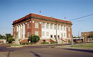
Phillips County courthouse in Helena-West Helena
|
|

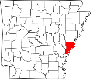
Location within the U.S. state of Arkansas
|
|
 Arkansas's location within the U.S. |
|
| Country | |
| State | |
| Founded | May 1, 1820 |
| Named for | Sylvanus Phillips |
| Seat | Helena-West Helena |
| Largest city | Helena-West Helena |
| Area | |
| • Total | 727 sq mi (1,880 km2) |
| • Land | 696 sq mi (1,800 km2) |
| • Water | 32 sq mi (80 km2) 4.4%% |
| Population
(2020)
|
|
| • Total | 16,568 |
| • Estimate
(2021)
|
15,906 |
| • Density | 22.790/sq mi (8.799/km2) |
| Time zone | UTC−6 (Central) |
| • Summer (DST) | UTC−5 (CDT) |
| Congressional district | 1st |
Phillips County is a county located in the eastern part of the U.S. state of Arkansas, in what is known as the Arkansas Delta along the Mississippi River. As of the 2020 census, the population was 16,568. The county seat is Helena–West Helena.
Phillips County is Arkansas's seventh (7th) county, formed on May 1, 1820. It was named for Sylvanus Phillips, the area's first-known white or European-American settler; he was elected as representative to the first Territorial Legislature of the Arkansas Territory. This fertile lowland area was developed for cotton plantations in the antebellum area and is still largely rural and agricultural.
The Helena-West Helena, AR Micropolitan Statistical Area includes all of Phillips County.
Contents
History
From September 30 – October 1, 1919, during the Elaine race riot in Phillips County, at least 237 African Americans were killed, attacked at large by armed whites trying to suppress the Progressive Farmers and Household Union of America which was organizing in the county.
Geography
According to the U.S. Census Bureau, the county has a total area of 727 square miles (1,880 km2), of which 696 square miles (1,800 km2) is land and 32 square miles (83 km2) (4.4%) is water.
Major highways
Adjacent counties
- Lee County (north)
- Tunica County, Mississippi (northeast)
- Coahoma County, Mississippi (east)
- Bolivar County, Mississippi (southeast)
- Desha County (south)
- Arkansas County (southwest)
- Monroe County (northwest)
National protected areas
- St. Francis National Forest (part)
- White River National Wildlife Refuge (part)
Demographics
| Historical population | |||
|---|---|---|---|
| Census | Pop. | %± | |
| 1830 | 1,152 | — | |
| 1840 | 3,547 | 207.9% | |
| 1850 | 6,935 | 95.5% | |
| 1860 | 14,877 | 114.5% | |
| 1870 | 15,372 | 3.3% | |
| 1880 | 21,262 | 38.3% | |
| 1890 | 25,341 | 19.2% | |
| 1900 | 26,561 | 4.8% | |
| 1910 | 33,535 | 26.3% | |
| 1920 | 44,530 | 32.8% | |
| 1930 | 40,683 | −8.6% | |
| 1940 | 45,970 | 13.0% | |
| 1950 | 46,254 | 0.6% | |
| 1960 | 43,997 | −4.9% | |
| 1970 | 40,046 | −9.0% | |
| 1980 | 34,772 | −13.2% | |
| 1990 | 28,838 | −17.1% | |
| 2000 | 26,445 | −8.3% | |
| 2010 | 21,757 | −17.7% | |
| 2020 | 16,568 | −23.8% | |
| 2023 (est.) | 14,961 | −31.2% | |
| U.S. Decennial Census 1790–1960 1900–1990 1990–2000 2010–2021 |
|||
2020 census
| Race | Num. | Perc. |
|---|---|---|
| White | 5,541 | 33.44% |
| Black or African American | 10,305 | 62.2% |
| Native American | 38 | 0.23% |
| Asian | 64 | 0.39% |
| Pacific Islander | 4 | 0.02% |
| Other/Mixed | 352 | 2.12% |
| Hispanic or Latino | 264 | 1.59% |
As of the 2020 United States Census, there were 16,568 people, 7,485 households, and 4,836 families residing in the county.
2010 census
As of the 2010 census, there were 21,757 people living in the county. 63.1% were Black or African American, 35.0% White, 0.3% Asian, 0.2% Native American, 0.4% of some other race and 0.9% of two or more races. 1.3% were Hispanic or Latino (of any race).
Education
School districts serving Phillips County include the Helena-West Helena School District, the Marvell–Elaine School District, and the Barton–Lexa School District.
Previously the Lake View School District served a portion of the county. On July 1, 2004, the Lake View district merged into the Barton–Lexa district. Previously the Elaine School District served another portion of the county. On July 1, 2006, the Elaine district merged into the Marvell district.
Marvell Academy, a private school founded in 1966 as a segregation academy, is in unincorporated Phillips County, near Marvell.
Communities
Cities
- Elaine
- Helena–West Helena (county seat)
- Lake View
- Marvell
Town
Unincorporated places
Townships
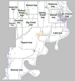
Townships in Arkansas are the divisions of a county. Each township includes unincorporated areas; some may have incorporated cities or towns within part of their boundaries. Arkansas townships have limited purposes in modern times. However, the United States Census does list Arkansas population based on townships (sometimes referred to as "county subdivisions" or "minor civil divisions"). Townships are also of value for historical purposes in terms of genealogical research. Each town or city is within one or more townships in an Arkansas county based on census maps and publications. The townships of Phillips County are listed below; listed in parentheses are the cities, towns, and/or census-designated places that are fully or partially inside the township.
| Township | FIPS code | ANSI code (GNIS ID) |
Population center(s) |
Pop. (2010) |
Pop. density (/mi2) |
Pop. density (/km2) |
Total area (mi2) |
Total area (km2) |
Land area (mi2) |
Land area (km2) |
Water area (mi2) |
Water area (km2) |
Geographic coordinates |
|---|---|---|---|---|---|---|---|---|---|---|---|---|---|
| Big Creek | 05-90273 | 00068945 | 425 | 11.05 | 4.26 | 38.474 | 99.65 | 38.474 | 99.65 | 0 | 0.000 | 34°29′04″N 90°53′36″W / 34.484468°N 90.893231°W | |
| Cleburne | 05-90849 | 00068946 | 660 | 29.12 | 11.24 | 22.692 | 58.77 | 22.665 | 58.70 | 0.027 | 0.06993 | 34°36′32″N 90°41′27″W / 34.608847°N 90.690904°W | |
| Cleveland | 05-90870 | 00068947 | 198 | 8.01 | 3.09 | 24.731 | 64.05 | 24.722 | 64.03 | 0.009 | 0.02331 | 34°28′46″N 90°58′19″W / 34.479487°N 90.971919°W | |
| Cypress | 05-91005 | 00068948 | 152 | 9.54 | 3.68 | 15.938 | 41.28 | 15.938 | 41.28 | 0 | 0.000 | 34°28′35″N 91°01′08″W / 34.476511°N 91.018900°W | |
| Hickory Ridge | 05-91704 | 00068949 | Marvell | 1,550 | 49.89 | 19.26 | 31.10 | 80.55 | 31.066 | 80.46 | 0.034 | 0.08806 | 34°35′11″N 90°56′11″W / 34.586411°N 90.936268°W |
| Hicksville | 05-91707 | 00068950 | 231 | 6.99 | 2.70 | 33.046 | 85.59 | 33.046 | 85.59 | 0 | 0.000 | 34°35′11″N 91°01′00″W / 34.586511°N 91.016744°W | |
| Hornor | 05-91767 | 00068951 | part of Helena-West Helena | 9,697 | 265.48 | 102.51 | 36.526 | 94.60 | 36.526 | 94.60 | 0 | 0.000 | 34°32′24″N 90°40′45″W / 34.539980°N 90.679052°W |
| Lake | 05-92094 | 00068953 | 41 | 0.91 | 0.35 | 50.741 | 131.4 | 44.870 | 116.2 | 5.871 | 15.21 | 34°24′38″N 90°40′36″W / 34.410535°N 90.676788°W | |
| Marion | 05-92391 | 00068955 | 589 | 14.42 | 5.57 | 40.865 | 105.8 | 40.846 | 105.8 | 0.019 | 0.04921 | 34°35′51″N 90°52′13″W / 34.597488°N 90.870256°W | |
| Mooney | 05-92547 | 00078865 | 179 | 1.70 | 0.66 | 115.059 | 298.0 | 105.231 | 272.5 | 9.828 | 25.45 | 34°11′30″N 90°58′10″W / 34.191547°N 90.969308°W | |
| St. Francis | 05-93276 | 00068956 | most of Helena-West Helena | 4,746 | 103.10 | 39.82 | 53.971 | 139.8 | 46.034 | 119.2 | 7.937 | 20.56 | 34°32′21″N 90°36′13″W / 34.539209°N 90.603521°W |
| Spring Creek | 05-93462 | 00068958 | Lexa, small part of Lake View | 1,789 | 22.46 | 8.67 | 79.694 | 206.4 | 79.648 | 206.3 | 0.046 | 0.1191 | 34°31′40″N 90°45′56″W / 34.527768°N 90.765687°W |
| Tappan | 05-93573 | 00068959 | Elaine, most of Lake View | 1,500 | 8.49 | 3.28 | 184.506 | 477.9 | 176.595 | 457.4 | 7.911 | 20.49 | 34°20′37″N 90°52′49″W / 34.343723°N 90.880168°W |
| Source:
Source: |
|||||||||||||
Notable people
- Bruce Bennett, Arkansas Attorney General
- Barry Williamson, attorney and member of the Texas Railroad Commission
- Blanche Lincoln, U.S. Senator
- Mark Lavon "Levon" Helm, drummer and singer for The Band
- Robert Lockwood Jr., blues guitarist and singer
- Angie Craig, U.S. Representative from Minnesota
See also
 In Spanish: Condado de Phillips (Arkansas) para niños


