Pemberton, New Jersey facts for kids
Quick facts for kids
Pemberton, New Jersey
|
|
|---|---|
|
Borough
|
|

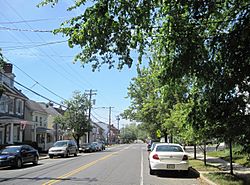
Center of the Borough of Pemberton
|
|

Pemberton Borough highlighted in Burlington County. Inset map: Burlington County highlighted in the State of New Jersey.
|
|

Census Bureau map of Pemberton, New Jersey
|
|
| Country | |
| State | |
| County | Burlington |
| Incorporated | December 15, 1826 |
| Government | |
| • Type | Borough |
| • Body | Borough Council |
| Area | |
| • Total | 0.61 sq mi (1.57 km2) |
| • Land | 0.59 sq mi (1.53 km2) |
| • Water | 0.02 sq mi (0.04 km2) 2.79% |
| Area rank | 540th of 565 in state 39th of 40 in county |
| Elevation | 36 ft (11 m) |
| Population
(2020)
|
|
| • Total | 1,371 |
| • Estimate
(2023)
|
1,376 |
| • Rank | 518th of 565 in state 36th of 40 in county |
| • Density | 2,325.2/sq mi (897.8/km2) |
| • Density rank | 268th of 565 in state 13th of 40 in county |
| Time zone | UTC−05:00 (Eastern (EST)) |
| • Summer (DST) | UTC−04:00 (Eastern (EDT)) |
| ZIP Code |
08068
|
| Area code(s) | 609 exchanges: 726, 894 |
| FIPS code | 3400557480 |
| GNIS feature ID | 0885346 |
| Website | |
Pemberton is a borough in Burlington County, in the U.S. state of New Jersey. As of the 2020 United States census, the borough's population was 1,371, a decrease of 38 (−2.7%) from the 2010 census count of 1,409, which in turn reflected an increase of 199 (+16.4%) from the 1,210 counted in the 2000 census. The township, and all of Burlington County, is a part of the Philadelphia–Reading–Camden combined statistical area and the Delaware Valley.
Pemberton was incorporated as a borough by an act of the New Jersey Legislature on December 15, 1826, within portions of New Hanover Township and Northampton Township (now known as Mount Holly Township). Pemberton became an independent borough c. 1894. The borough is named for James Pemberton, a property owner in the area.
It is a dry community, where alcohol is not permitted to be sold legally, as affirmed by the most recent referendum which was held in 1980.
Contents
Geography
According to the United States Census Bureau, the borough had a total area of 0.61 square miles (1.57 km2), including 0.59 square miles (1.53 km2) of land and 0.02 square miles (0.04 km2) of water (2.79%).
Pemberton is an independent municipality within the boundaries of and completely surrounded by Pemberton Township, making it one of 21 pairs of "doughnut towns" in the state, where one municipality entirely surrounds another.
Demographics
| Historical population | |||
|---|---|---|---|
| Census | Pop. | %± | |
| 1870 | 797 | — | |
| 1880 | 799 | 0.3% | |
| 1890 | 834 | 4.4% | |
| 1900 | 771 | −7.6% | |
| 1910 | 797 | 3.4% | |
| 1920 | 800 | 0.4% | |
| 1930 | 783 | −2.1% | |
| 1940 | 906 | 15.7% | |
| 1950 | 1,194 | 31.8% | |
| 1960 | 1,250 | 4.7% | |
| 1970 | 1,344 | 7.5% | |
| 1980 | 1,198 | −10.9% | |
| 1990 | 1,367 | 14.1% | |
| 2000 | 1,210 | −11.5% | |
| 2010 | 1,409 | 16.4% | |
| 2020 | 1,371 | −2.7% | |
| 2023 (est.) | 1,376 | −2.3% | |
| Population sources: 1870–2000 1870–1920 1870 1880–1890 1890–1910 1910–1930 1940–2000 2000 2010 2020 |
|||
2010 census
The 2010 United States census counted 1,409 people, 581 households, and 404 families in the borough. The population density was 2,408.7 per square mile (930.0/km2). There were 642 housing units at an average density of 1,097.5 per square mile (423.7/km2). The racial makeup was 74.38% (1,048) White, 15.26% (215) Black or African American, 0.21% (3) Native American, 3.26% (46) Asian, 0.00% (0) Pacific Islander, 3.12% (44) from other races, and 3.76% (53) from two or more races. Hispanic or Latino of any race were 12.70% (179) of the population.
Of the 581 households, 25.1% had children under the age of 18; 51.3% were married couples living together; 13.1% had a female householder with no husband present and 30.5% were non-families. Of all households, 24.1% were made up of individuals and 6.9% had someone living alone who was 65 years of age or older. The average household size was 2.42 and the average family size was 2.79.
19.0% of the population were under the age of 18, 8.9% from 18 to 24, 25.2% from 25 to 44, 33.6% from 45 to 64, and 13.3% who were 65 years of age or older. The median age was 43.1 years. For every 100 females, the population had 90.7 males. For every 100 females ages 18 and older there were 90.5 males.
The Census Bureau's 2006–2010 American Community Survey showed that (in 2010 inflation-adjusted dollars) median household income was $65,568 (with a margin of error of +/− $9,899) and the median family income was $74,773 (+/− $17,679). Males had a median income of $44,750 (+/− $5,830) versus $46,406 (+/− $8,202) for females. The per capita income for the borough was $36,399 (+/− $6,078). About 2.8% of families and 6.0% of the population were below the poverty line, including 12.5% of those under age 18 and 1.8% of those age 65 or over.
Historic district
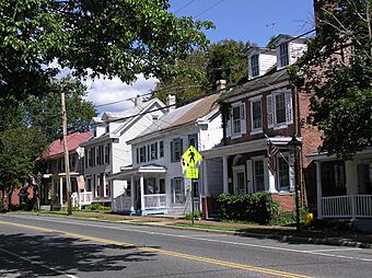
The Pemberton Historic District is a 94-acre (38 ha) historic district encompassing the borough. It was added to the National Register of Historic Places on March 22, 1989, for its significance in historic archaeology, architecture, industry, religion and exploration/settlement. The district has 180 contributing buildings, including the individually listed Morris Mansion and Mill.
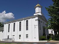
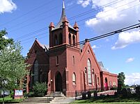
The First Baptist Church was organized in 1752. The current church on Hanover Street was built in 1861 with Greek Revival style. The Methodist Church was founded in 1774, the third in the state. The current church was built in 1895.
Education
The Pemberton Borough School District is no longer operational. Starting with the 2007–08 school year, all public school students from Pemberton Borough attend the schools of the Pemberton Township School District, with Pemberton Borough a part of the combined school district. The district is one of 31 former Abbott districts statewide that were established pursuant to the decision by the New Jersey Supreme Court in Abbott v. Burke which are now referred to as "SDA Districts" based on the requirement for the state to cover all costs for school building and renovation projects in these districts under the supervision of the New Jersey Schools Development Authority. The school district serves Pemberton Borough and Pemberton Township (including the communities of Browns Mills, Country Lake Estates, Pemberton Heights and Presidential Lakes Estates and the Pemberton Township portion of Fort Dix). As of the 2021–22 school year, the district, comprising nine schools, had an enrollment of 4,443 students. Schools in the district (with 2021–22 enrollment data from the National Center for Education Statistics) are Pemberton Early Childhood Education Center (with 416 students; PreK), Samuel T. Busansky Elementary School (281; 3–5), Denbo-Crichton Elementary School (850; K–5), Howard L. Emmons Elementary School (293; K–2), Fort Dix Elementary School (317; PreK–5), Joseph S. Stackhouse Elementary School (223; K–2), Marcus Newcomb Middle School (307; 6), Helen A. Fort Middle School (661; 7–8) and Pemberton Township High School (1,029; 9–12).
Students from Pemberton, and from all of Burlington County, are eligible to attend the Burlington County Institute of Technology, a countywide public school district that serves the vocational and technical education needs of students at the high school and post-secondary level at its campuses in Medford and Westampton.
Transportation
Roads and highways
As of May 2010[update], the borough had a total of 8.81 miles (14.18 km) of roadways, of which 4.99 miles (8.03 km) were maintained by the municipality and 3.82 miles (6.15 km) by Burlington County.
No Interstate, U.S. or state highways directly serve Pemberton. The most significant roadway passing through the borough is County Route 530.
Public transportation
NJ Transit provides bus service in the township on the 317 route between Asbury Park and Philadelphia. BurLink bus service is offered on the B1 route between Beverly and Pemberton.
Notable people
People who were born in, residents of, or otherwise closely associated with Pemberton include:
- Jeff Celentano (born 1960), actor, screenwriter and director
- George Franklin Fort (1808–1872), 16th Governor of New Jersey
- John Franklin Fort (1852–1920), 33rd Governor of New Jersey, from 1908 to 1911
- Bushrod W. Lott (1826–1886), politician in the Minnesota Territory who served as United States Consul in Tehuantepec, Mexico, from 1862 to 1865, appointed by President Abraham Lincoln
- Rex Marshall (1919–1983), actor, television announcer and radio personality
- Isaac Witkin (1936–2006), sculptor
See also
 In Spanish: Pemberton (Nueva Jersey) para niños


