Paxton, Florida facts for kids
Quick facts for kids
Paxton, Florida
|
|
|---|---|
| Town of Paxton | |

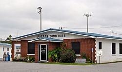
Paxton Town Hall, September 2014.
|
|

Location in Walton County and the state of Florida
|
|
| Country | |
| State | |
| County | Walton |
| Settled | 1903 |
| Incorporated | 1952 |
| Government | |
| • Type | Mayor-Council |
| Area | |
| • Total | 4.01 sq mi (10.38 km2) |
| • Land | 3.72 sq mi (9.64 km2) |
| • Water | 0.28 sq mi (0.73 km2) |
| Elevation | 318 ft (97 m) |
| Population
(2020)
|
|
| • Total | 556 |
| • Density | 149.30/sq mi (57.65/km2) |
| Time zone | UTC-6 (Central (CST)) |
| • Summer (DST) | UTC-5 (CDT) |
| ZIP code |
32538
|
| Area code(s) | 850, 448 |
| FIPS code | 12-55475 |
| GNIS feature ID | 0288591 |
Paxton is a town in Walton County, Florida, United States. Located near Britton Hill on the Alabama–Florida state line, it has the highest elevation of any in Florida. The Town of Paxton is located on the Florida Panhandle, and is part of the Crestview–Fort Walton Beach–Destin, Florida Metropolitan Statistical Area. The population was 556 as of the 2020 census, down from 644 at the 2010 census.
Geography

The approximate coordinates for the Town of Paxton is located at 30°58′43″N 86°18′42″W / 30.97861°N 86.31167°W.
Paxton is on the state line with Alabama, being bordered by the town of Florala on the north.
The highest natural point in Florida, Britton Hill, is located close to the town limits.
According to the United States Census Bureau, the town has a total area of 4.0 square miles (10 km2), of which 3.9 square miles (10 km2) is land and 0.1 square miles (0.26 km2) (1.76%) is water.
At an elevation of 318 feet (97 meters), Paxton is the highest incorporated municipality in Florida.
Climate
The climate in this area is characterized by hot, humid summers and generally mild winters. According to the Köppen climate classification, the Town of Paxton has a humid subtropical climate zone (Cfa).
Demographics
| Historical population | |||
|---|---|---|---|
| Census | Pop. | %± | |
| 1960 | 215 | — | |
| 1970 | 243 | 13.0% | |
| 1980 | 659 | 171.2% | |
| 1990 | 600 | −9.0% | |
| 2000 | 656 | 9.3% | |
| 2010 | 644 | −1.8% | |
| 2020 | 556 | −13.7% | |
| U.S. Decennial Census | |||
2010 and 2020 census
| Race | Pop 2010 | Pop 2020 | % 2010 | % 2020 |
|---|---|---|---|---|
| White (NH) | 568 | 477 | 88.20% | 85.79% |
| Black or African American (NH) | 22 | 17 | 3.42% | 3.06% |
| Native American or Alaska Native (NH) | 17 | 14 | 2.64% | 2.52% |
| Asian (NH) | 3 | 0 | 0.47% | 0.00% |
| Pacific Islander or Native Hawaiian (NH) | 1 | 0 | 0.16% | 0.00% |
| Some other race (NH) | 2 | 4 | 0.31% | 0.72% |
| Two or more races/Multiracial (NH) | 15 | 24 | 2.33% | 4.32% |
| Hispanic or Latino (any race) | 16 | 20 | 2.48% | 3.60% |
| Total | 644 | 556 |
As of the 2020 United States census, there were 556 people, 298 households, and 210 families residing in the town.
As of the 2010 United States census, there were 644 people, 295 households, and 183 families residing in the town.
See also
 In Spanish: Paxton (Florida) para niños

