Passage Canal facts for kids
Quick facts for kids Passage Canal |
|
|---|---|

Passage Canal
|
|
| Location | Kenai Peninsula, Alaska |
| Coordinates | 60°48′47″N 148°32′46″W / 60.813°N 148.546°W |
| Primary inflows | Whittier Creek, Learnard Creek, Cove Creek, Billings Creek, Seth River |
| Basin countries | United States |
| Max. length | 11 mi (18 km) |
| Max. width | 2 mi (3.2 km) |
| Average depth | 1,128 ft (344 m) |
| Max. depth | 1,290 ft (390 m) |
| Frozen | Never |
| Islands | None |
| Sections/sub-basins | Shotgun Cove, Emerald Bay, Squirrel Cove, Poe Bay, Logging Camp Bay |
| Settlements | Whittier |
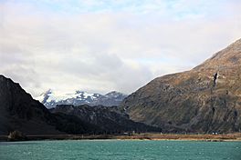
Passage Canal is a bay of Prince William Sound on the east coast of the Kenai Peninsula of Alaska, United States. Its only settlement is the small town of Whittier, located near the head of the bay.
It is called the gateway to Prince William Sound as many water taxis, kayak tours, anglers, and recreational boaters use the bay to access nearby state marine parks and federal cabins.
The town of Whittier was founded along the banks of Passage Canal to serve as a secret deep water port for the U.S. Military during World War II.

All content from Kiddle encyclopedia articles (including the article images and facts) can be freely used under Attribution-ShareAlike license, unless stated otherwise. Cite this article:
Passage Canal Facts for Kids. Kiddle Encyclopedia.

