Passagassawakeag River facts for kids
Quick facts for kids Passagassawaukeag River |
|
|---|---|

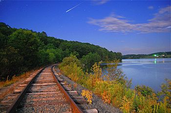
A moonlight view of the Passagassawaukeag River along the tracks of the Belfast and Moosehead Lake Railroad just beyond the old Upper Bridge a little more than a mile inland from Belfast, ME, where it empties into Belfast Bay.
|
|
| Country | United States |
| Physical characteristics | |
| Main source | Lake Passagassawakeag Maine 308 feet (90 m) |
| River mouth | Belfast Bay sea level 44°25′48″N 69°00′22″W / 44.430°N 69.006°W |
The Passagassawaukeag River is a 16-mile-long (26 km) river in Waldo County, Maine in the United States. From the outlet of Lake Passagassawakeag (44°30′04″N 69°07′59″W / 44.5012°N 69.13295°W) in Brooks, it runs south and east to its estuary in Belfast, Maine. The river empties into Belfast Bay, an inlet of Penobscot Bay, where it passes under US Route 1.
The waterway's name is of local Native American origin and is believed to mean "a sturgeon's place" or "a place for spearing sturgeon by torchlight."

All content from Kiddle encyclopedia articles (including the article images and facts) can be freely used under Attribution-ShareAlike license, unless stated otherwise. Cite this article:
Passagassawakeag River Facts for Kids. Kiddle Encyclopedia.

