Panther Creek (Little Schuylkill River tributary) facts for kids
Quick facts for kids Panther Creek |
|
|---|---|
 |
|
| Physical characteristics | |
| Main source | Over the Lehigh Valley drainage divide due west of Palmerton, Pennsylvania below Mount Pisgah (below the join of Pisgah Ridge with Nesquehoning Mountain and Mauch Chunk Mountain). |
| River mouth | Little Schuylkill River at Tamaqua, Pennsylvania 40°47′46″N 75°57′58″W / 40.79600°N 75.96613°W |
| Length | ca. 8 mi (13 km) |
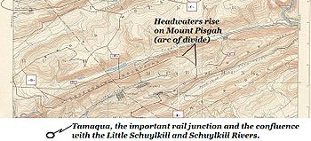
Panther Creek is a west-draining left-bank tributary of the Little Schuylkill River's drainage basin and rises in the vicinity of the east side of Lansford in the plateau-like nearly flat terrain of the complex three-way saddle between Mount Pisgah to its east, Nesquehoning Ridge to the north and Pisgah Ridge to the south, both ridgelines flanking its entire course as it makes its way ENE-to-WSW.
The creek's valley is historically and industrially important having been mostly owned by the historically significant Lehigh Coal & Navigation Company which eventually built the Panther Creek Railroad from Lansford to Tamaqua, PA and the Hauto Tunnel to haul coal from the copious anthracite deposits, collieries, and coal breakers along an easier route than up and over the mountains to Mauch Chunk and the Lehigh Canal via Summit Hill, PA and the Mauch Chunk & Summit Hill Railway, North America's second oldest operational railroad and both its first Gravity & Switchback railroads. The coal seams of the valley were the first deposits discovered and exploited by any company beginning with surface deposits along the south ridge leading to the founding of Summit Hill, then Lansford in western Carbon County, then the downstream towns of Coaldale and Tamaqua in eastern Schuylkill County.
Today the so called 'New Company', a leaned-down and reorganized Lehigh Coal and Navigation Company (note the slight title change) still mines the coal deposits in the valley and owns all of its mineral rights.

