Pantapin, Western Australia facts for kids
Quick facts for kids PantapinWestern Australia |
|
|---|---|

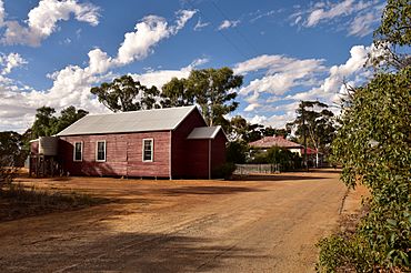
Railway Street, Pantapin, 2018
|
|
| Established | 1913 |
| Postcode(s) | 6384 |
| Elevation | 344 m (1,129 ft) |
| Area | [convert: needs a number] |
| Location |
|
| LGA(s) | Shire of Quairading |
| State electorate(s) | Central Wheatbelt |
| Federal Division(s) | O'Connor |
Pantapin is a small town in the Wheatbelt region of Western Australia.
The town originated as a railway siding that was planned in 1912 as part of the Quairading to Bruce Rock line. The town was initially named Ulakain, after a nearby well, and was gazetted under that name in 1914.
The name proved problematic – causing mail and goods to go missing, according to the residents – and was changed in 1921.
Black History Month on Kiddle
Famous African-American Architects:
 | Georgia Louise Harris Brown |
 | Julian Abele |
 | Norma Merrick Sklarek |
 | William Sidney Pittman |

All content from Kiddle encyclopedia articles (including the article images and facts) can be freely used under Attribution-ShareAlike license, unless stated otherwise. Cite this article:
Pantapin, Western Australia Facts for Kids. Kiddle Encyclopedia.
