Okanogan, Washington facts for kids
Quick facts for kids
Okanogan
|
||
|---|---|---|
| City of Okanogan | ||

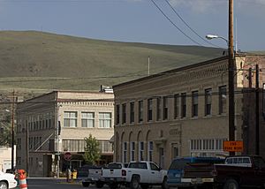
Skyline of downtown Okanogan
|
||
|
||
| Motto(s):
100 Years of Community Pride
|
||

Location of Okanogan in
Okanogan County, Washington |
||
| Country | United States | |
| State | Washington | |
| County | Okanogan | |
| Established | 1888 | |
| Incorporated | October 29, 1907 | |
| Government | ||
| • Type | Mayor–council | |
| Area | ||
| • City | 2.12 sq mi (5.48 km2) | |
| • Land | 2.01 sq mi (5.20 km2) | |
| • Water | 0.11 sq mi (0.28 km2) | |
| • Urban | 4.736 sq mi (12.267 km2) | |
| Elevation | 840 ft (256 m) | |
| Population
(2020)
|
||
| • City | 2,379 | |
| • Density | 1,122.2/sq mi (434.1/km2) | |
| Time zone | UTC-8 (PST) | |
| • Summer (DST) | UTC-7 (PDT) | |
| ZIP code |
98840
|
|
| Area code(s) | 509 | |
| FIPS code | 53-50920 | |
| GNIS feature ID | 1531489 | |
Okanogan (/ˌoʊkəˈnɒɡən/ OH-kə-NOG-ən; derived from Syilx'tsn: "rendezvous" or "meeting place") is a city in Okanogan County, Washington, United States. The population was 2,379 at the 2020 census, down from 2,552 at the 2010 census, within the Greater Omak Area. It is the seat of Okanogan County.
It has a small commuter airfield, Okanogan Legion Airport – (S35) with one paved runway of 2,533 ft (772 m) in length.
History
Okanogan was officially incorporated on October 29, 1907.
A pair of 115 year old 60 ft (18 m) long murals were discovered during renovation of a 1907 commercial building in January 2022. The murals were initially tentatively attributed to Western photographer Frank S. Matsura as the building had been used as a theater several times and Matsura had played in the Okanogan County Band on stage there. The mural is painted on canvases split between the north and south walls, and a 1915 newspaper clipping found by the Okanogan County Historical Society provided coverage of plans for the murals. Then the Hub Theater, the building was planned to incorporate panoramic scenery murals in tans painted by a local artist. further investigation lead to attribution of the murals to a Wenatchee painter W.J. McConnon. The owners planned to take the murals down for restoration before rehanging them as the centerpiece of a historical exhibit.
Geography
Okanogan is located at 48°22′0″N 119°34′52″W / 48.36667°N 119.58111°W (48.366694, −119.581139).
According to the United States Census Bureau, the city has a total area of 2.00 square miles (5.18 km2), of which, 1.95 square miles (5.05 km2) is land and 0.05 square miles (0.13 km2) is water.
The town is located along the Okanogan River.
Climate
Okanogan experiences a semi-arid climate (Köppen climate classification: BSk). A weather station is located in nearby Omak.
| Climate data for Omak (1909–2013) | |||||||||||||
|---|---|---|---|---|---|---|---|---|---|---|---|---|---|
| Month | Jan | Feb | Mar | Apr | May | Jun | Jul | Aug | Sep | Oct | Nov | Dec | Year |
| Record high °F (°C) | 60 (16) |
63 (17) |
79 (26) |
96 (36) |
101 (38) |
117 (47) |
114 (46) |
107 (42) |
102 (39) |
90 (32) |
77 (25) |
67 (19) |
117 (47) |
| Mean daily maximum °F (°C) | 30.2 (−1.0) |
38.3 (3.5) |
51.9 (11.1) |
64.1 (17.8) |
73.5 (23.1) |
80.6 (27.0) |
88.8 (31.6) |
87.1 (30.6) |
77.1 (25.1) |
62.2 (16.8) |
43.6 (6.4) |
33.0 (0.6) |
60.9 (16.1) |
| Daily mean °F (°C) | 23.4 (−4.8) |
29.9 (−1.2) |
40.4 (4.7) |
50.1 (10.1) |
58.4 (14.7) |
65.4 (18.6) |
72.2 (22.3) |
70.5 (21.4) |
61.2 (16.2) |
48.8 (9.3) |
35.5 (1.9) |
26.9 (−2.8) |
48.6 (9.2) |
| Mean daily minimum °F (°C) | 16.6 (−8.6) |
21.5 (−5.8) |
29.0 (−1.7) |
36.1 (2.3) |
43.3 (6.3) |
50.2 (10.1) |
55.6 (13.1) |
53.9 (12.2) |
45.3 (7.4) |
35.5 (1.9) |
27.5 (−2.5) |
20.8 (−6.2) |
36.3 (2.4) |
| Record low °F (°C) | −22 (−30) |
−26 (−32) |
−7 (−22) |
15 (−9) |
19 (−7) |
30 (−1) |
35 (2) |
31 (−1) |
20 (−7) |
8 (−13) |
−6 (−21) |
−21 (−29) |
−26 (−32) |
| Average precipitation inches (mm) | 1.32 (34) |
1.08 (27) |
0.83 (21) |
0.87 (22) |
0.98 (25) |
1.13 (29) |
0.61 (15) |
0.49 (12) |
0.56 (14) |
0.89 (23) |
1.44 (37) |
1.66 (42) |
11.86 (301) |
| Average snowfall inches (cm) | 7.3 (19) |
4.0 (10) |
0.7 (1.8) |
0 (0) |
0 (0) |
0 (0) |
0 (0) |
0 (0) |
0 (0) |
0 (0) |
2.5 (6.4) |
7.7 (20) |
22.3 (57) |
| Average precipitation days (≥ 0.01 in) | 8 | 6 | 5 | 5 | 5 | 6 | 3 | 3 | 4 | 5 | 8 | 9 | 68 |
| Source: Western Regional Climate Center, The Weather Channel | |||||||||||||
Demographics
| Historical population | |||
|---|---|---|---|
| Census | Pop. | %± | |
| 1910 | 611 | — | |
| 1920 | 1,015 | 66.1% | |
| 1930 | 1,519 | 49.7% | |
| 1940 | 1,735 | 14.2% | |
| 1950 | 2,013 | 16.0% | |
| 1960 | 2,001 | −0.6% | |
| 1970 | 2,015 | 0.7% | |
| 1980 | 2,326 | 15.4% | |
| 1990 | 2,370 | 1.9% | |
| 2000 | 2,484 | 4.8% | |
| 2010 | 2,552 | 2.7% | |
| 2020 | 2,379 | −6.8% | |
| U.S. Decennial Census 2020 Census |
|||
2010 census
As of the 2010 census, there were 2,552 people, 983 households, and 619 families living in the city. The population density was 1,308.7 inhabitants per square mile (505.3/km2). There were 1,051 housing units at an average density of 539.0 per square mile (208.1/km2). The racial makeup of the city was 79.8% White, 0.5% African American, 7.9% Native American, 0.4% Asian, 0.2% Pacific Islander, 6.4% from other races, and 4.8% from two or more races. Hispanic or Latino of any race were 14.1% of the population.
There were 983 households, of which 32.6% had children under the age of 18 living with them, 40.6% were married couples living together, 15.8% had a female householder with no husband present, 6.6% had a male householder with no wife present, and 37.0% were non-families. 30.1% of all households were made up of individuals, and 11.4% had someone living alone who was 65 years of age or older. The average household size was 2.39 and the average family size was 2.91.
The median age in the city was 37.7 years. 24.2% of residents were under the age of 18; 10.1% were between the ages of 18 and 24; 24.3% were from 25 to 44; 26.6% were from 45 to 64; and 14.9% were 65 years of age or older. The gender makeup of the city was 50.7% male and 49.3% female.
Sister city
Okanogan has one Sister City:
 Keremeos, British Columbia, Canada
See also
 In Spanish: Okanogan (Washington) para niños


