Ogun State facts for kids
Quick facts for kids
Ogun State
|
||
|---|---|---|
|
State
|
||
|
||
| Nickname(s):
Gateway State
|
||

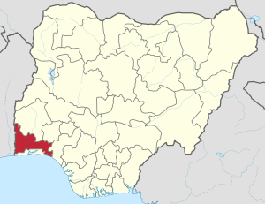
Location of Ogun State in Nigeria
|
||
| Country | ||
| Date created | 3 February 1976 | |
| Capital | Abeokuta | |
| Area | ||
| • Total | 16,980.55 km2 (6,556.23 sq mi) | |
| Area rank | 24th of 36 | |
| Population
(2006 census)
|
||
| • Total | 3,751,140 | |
| • Rank | 16 of 36 | |
| • Density | 220.9080/km2 (572.1492/sq mi) | |
| Demonym(s) | Ogun | |
| GDP | ||
| • Year | 2007 | |
| • Total | $10.47 billion | |
| • Per capita | $2,740 | |
| Time zone | UTC+01 (WAT) | |
| ISO 3166 code | NG-OG | |
Ogun State is one of the 36 states in Nigeria. It is presently governed by Ibikunle Amosun and its capital is Abeokuta. The state consists of 20 local government areas including:
- Abeokuta North
- Abeokuta South
- Ado-Odo/Ota
- Ewekoro
- Ifo
- Ijebu East
- Ijebu North
- Ijebu North East
- Ijebu Ode
- Ikenne
- Imeko Afon
- Ipokia
- Obafemi Owode
- Odogbolu
- Odeda
- Ogun Waterside
- Remo North
- Sagamu
(Shagamu) - Yewa North
(formerly Egbado North) - Yewa South
(formerly Egbado South)
See also
 In Spanish: Estado de Ogun para niños

All content from Kiddle encyclopedia articles (including the article images and facts) can be freely used under Attribution-ShareAlike license, unless stated otherwise. Cite this article:
Ogun State Facts for Kids. Kiddle Encyclopedia.

