North Toowoomba, Queensland facts for kids
Quick facts for kids North ToowoombaToowoomba, Queensland |
|||||||||||||||
|---|---|---|---|---|---|---|---|---|---|---|---|---|---|---|---|

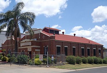
The Downs Co-operative Dairy Association Limited Factory, 2014
|
|||||||||||||||
| Population | 3,332 (2021 census) | ||||||||||||||
| • Density | 1,670/km2 (4,300/sq mi) | ||||||||||||||
| Postcode(s) | 4350 | ||||||||||||||
| Area | 2.0 km2 (0.8 sq mi) | ||||||||||||||
| Time zone | AEST (UTC+10:00) | ||||||||||||||
| Location |
|
||||||||||||||
| LGA(s) | Toowoomba Region | ||||||||||||||
| State electorate(s) | Toowoomba North | ||||||||||||||
| Federal Division(s) | Groom | ||||||||||||||
|
|||||||||||||||
North Toowoomba is a suburban locality in Toowoomba in the Toowoomba Region, Queensland, Australia. In the 2021 census, North Toowoomba had a population of 3,332 people.
Geography
North Toowoomba is located directly north of the Toowoomba city centre.
The New England Highway travels along Ruthven Street, entering the suburb from the north (Harlaxton) and exiting to the south (Toowoomba CBD).
The Main Line railway also enters the suburb from the north (Harlaxton) and exits to the south (Toowoomba CBD). The Western railway line enters the suburb from the south (Toowoomba CBD) and exits to the north-west forming the boundary between Rockville and Harlaxton. There are no railway stations in the suburb, although historically there were railway sidings for industrial use, e.g. the dairy factory.
History
Toowoomba North Boys State School and Toowoomba North Girls and Infants State School both opened in 1869. In 1937 the two schools were combined to form Toowoomba North State School. However, despite the name, the school is officially within Toowoomba City rather than in North Toowoomba.
St Thomas' Anglican Church was dedicated on 21 December 1920 by Archdeacon Osborn. The church building had been relocated from Ruthven Street near the railway line where it was no longer needed to 2 Allan Street (corner of Jellicoe Street ,27°32′48″S 151°57′28″E / 27.5466°S 151.9579°E). The church's closure on 3 February 2008 was approved by Assistant Bishop Nolan. It has been converted into a private home.
Demographics
In the 2006 census, North Toowoomba had a population of 3,062 people.
In the 2011 census, North Toowoomba had a population of 3,049 people.
In the 2016 census, North Toowoomba had a population of 2,953 people.
In the 2021 census, North Toowoomba had a population of 3,332 people.
Heritage listings
There are a number of heritage-listed sites in North Toowoomba, including:
- 57 Brook Street: The Downs Co-operative Dairy Association Limited Factory
Education
There are no government schools in North Toowoomba. The nearest government primary schools are Harlaxton State School in neighbouring Harlaxton to the north, Toowoomba East State School in neighbouring East Toowoomba to the south-east, and Toowoomba North State School which, despite its name, is in neighbouring Toowoomba City to the south. The nearest government secondary school in Toowoomba State High School in neighbouring Mount Lofty to the east.
Amenities
Martin Klein Park (also known as North Toowoomba Park) is at 130-136 Jellicoe Road (27°32′47″S 151°57′10″E / 27.5463°S 151.9527°E). It has a cricket oval, playground, and picnic facilities.


