North Shore, New Zealand facts for kids
Quick facts for kids
North Shore
|
|
|---|---|

The North Shore captured by a Planet Labs satellite in 2016
|
|
| Country | New Zealand |
| Island | North Island |
| Region | Auckland Region |
| Area | |
| • Total | 116.64 km2 (45.03 sq mi) |
| Population
(June 2023 )
|
|
| • Total | 248,997 |
| • Density | 2,134.75/km2 (5,528.97/sq mi) |
The North Shore (Māori: Te Whenua Roa ō Kahu or Māori: Te Raki Paewhenua) is one of the major geographical regions of Auckland, the largest city in New Zealand. The area is defined as the northern shores of the Waitematā Harbour as far north as the Ōkura River.
The North Shore is primarily uplifted Waitemata Group sandstone from the Miocene, and includes the northernmost features of the Auckland volcanic field, such as Lake Pupuke, the oldest known feature of the field. Settled by Tāmaki Māori in the 13th or 14th centuries, the Waitematā Harbour headlands became important places for harvesting seasonal resources and for controlling transportation across the region. European settlers arrived in the North Shore in the 1840s, and by the turn of the 20th century, the inland area has become a hub for fruit growing, while the eastern coast had developed into a tourism destination for Aucklanders.
The North Shore rapidly suburbanised after the construction of the Auckland Harbour Bridge in 1959, and by 1989 the five local authorities in the area amalgamated to create North Shore City, which existed until 2010.
Contents
Definition and etymology
The name North Shore has been used in English as far back as 1843, and has traditionally been defined as the area north of the Waitematā Harbour as far as Lucas Creek and Ōkura River. Other areas referred to as part of the North Shore include Pāremoremo, Lucas Heights, and Dairy Flat, the latter of which is the home of North Shore Aerodrome. Ōkura and Redvale, rural villages located between metropolitan Auckland and the Hibiscus Coast, are considered a part of the North Shore. Major centres on the North Shore include Albany, Birkenhead, Browns Bay, Devonport, Glenfield, Northcote and Takapuna.
Te Whenua Roa o Kahu and Te Raki Paewhenua are the two most commonly used Māori language names for the North Shore. Te Whenua Roa o Kahu ("The Greater Lands of Kahu") name refers to Kahu, the granddaughter of Maki, the namesake ancestor of the iwi Te Kawerau ā Maki. Kahu was among the members of Te Kawerau ā Maki who was based on the North Shore. Te Raki Paewhenua is a name that has been in use since at least the 1980s, and is found in the names of organisations such as Te Kura Kaupapa Māori o Te Raki Paewhenua, Te Raki Paewhenua Committee, and the health and social service organisation Te Puna Hauora o te Raki Paewhenua.
In the mid-19th century, Māori language texts predominantly use the names Takapuna, or Awataha, to describe the North Shore. Takapuna, a name originally given to a spring at Maungauika / North Head, had gradually grown to refer to the wider southern North Shore area before the early colonial era.
Geology
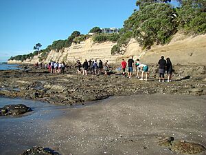
The North Shore is primarily uplifted Waitemata Group sandstone, that was deposited on the sea floor during the Early Miocene, between 22 and 16 million years ago, and uplifted due to tectonic forces. The sedimentary layers of Waitemata sandstone can be clearly seen in the eroding cliff faces of the bays along the Hauraki Gulf. Basement rocks in the area are greywacke and argillite, and a number of the headlands are formed from harder Parnell grit rocks, produced by lahars during the Miocene. The North Shore and wider Rodney area feature small areas of Albany Conglomerate rock.
Volcanic features
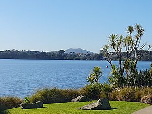
The North Shore is home to the northernmost features of the Auckland volcanic field. Lake Pupuke, a volcanic maar located in Takapuna, is one of the oldest known features of the Auckland volcanic field, erupting an estimated 193,200 years ago. During the eruption of Lake Pupuke, two lava flows travelled eastwards through the area, burning vegetation and encasing the lower 1-2 metres of the tree trunks in lava. The lava solidified into basalt rock, creating the Takapuna Fossil Forest, which was exposed an estimated 7,000 years ago due to coastal erosion.
There are two volcanic maars found on the eastern coastline of Northcote: Tank Farm, also known as Tuff Crater or Te Kōpua ō Matakamokamo, joined to the south by Onepoto (also known as Te Kōpua ō Matakerepo). Onepoto and Tank Farm erupted an estimated 187,600 and 181,000 years ago respectively.
Three volcanic features can be found at Devonport: Takarunga / Mount Victoria, the highest volcano on the North Shore at 81 metres (266 ft), and Maungauika / North Head, the south-east headland of the North Shore located at the mouth of the Waitematā Harbour. The third feature, Takararo / Mount Cambria, was quarried in tis entirety by the 1970s. Of these three features, Maungauika / North Head is significantly older, dated to approximately 87,000 years ago. Takararo / Mount Cambria is estimated to have erupted 43,000 years ago, while Takarunga / Mount Victoria erupted approximately 35,000 years ago.
While not located on the North Shore, the 260 metres (850 ft) Rangitoto Island, dominates the horizon for many of the bays along the eastern coast. The island is the youngest feature of the field, having erupted around the year 1,500.
Geography
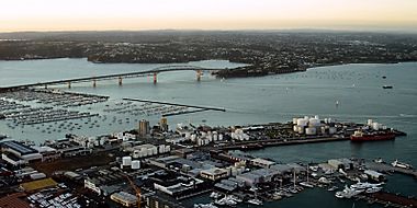
The North Shore comprises a large suburban area to the north of downtown Auckland; linked to the rest of the greater Auckland metropolitan area by two harbour bridges – the Auckland Harbour Bridge crosses the inner Waitemata Harbour to Auckland City, while the Upper Harbour Bridge provides a connection to Auckland's western suburbs Waitakere across the northern stretches of the harbour.
The North Shore has been administered by various councils over the years, in the most recent past the North Shore City Council. On 1 November 2010, North Shore City Council and the six other local councils and Auckland Regional Council merged to create Auckland Council.
The administrative area of North Shore City Council was bounded by Rodney District to the north, Waitemata Harbour to the south and the Rangitoto Channel of the Hauraki Gulf to the east. The seat of the council was in Takapuna. The city was divided into three wards, Harbour, Northern and Central, and each ward is further divided into two community boards. Inner suburbs include Milford, Takapuna, Belmont, Devonport, Bayswater, Northcote, Birkenhead, Highbury, Hillcrest, Glenfield, Wairau Valley, Westlake and Forrest Hill. Outer suburbs include Birkdale, Beach Haven, North Harbour, Albany, Greenhithe, Long Bay*, Torbay*, Waiake*, Browns Bay*, Rothesay Bay*, Murrays Bay*, Mairangi Bay*, Campbells Bay*, Sunnynook and Castor Bay. Those here with an asterisk, along with several other beaches on the Hauraki Gulf coast, are collectively known as East Coast Bays.
Today, the entire area has been divided between four local boards of the amalgamated Auckland Council: Devonport-Takapuna, Kaipatiki, Upper Harbour (along with part of the former Waitakere City) and Hibiscus and Bays (along with part of the former Rodney District)
Flora
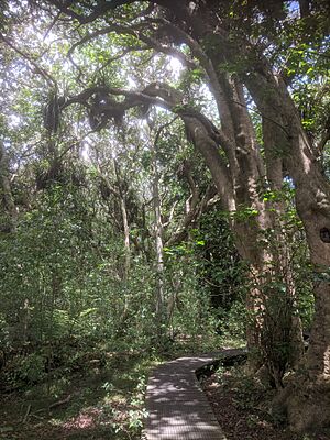
Prior to human settlement, the inland North Shore area was primarily a northern broadleaf podocarp forest, dominated by kauri, tōtara, mataī, miro, kauri and kahikatea trees. Pōhutukawa trees were a major feature of the coastline. By the 19th century, much of the North Shore primarily scrubland, vegetated by plants such as mānuka, tutu, harakeke flax and ferns.
Some kauri remnant forest remains in areas around Birkenhead, including Kauri Park and Le Roys Bush, while Smiths Bush in the Onewa Domain is a remnant native forest dominated by kahikatea and taraire trees. Fernhill Escarpment in Albany is a remnant forest which had tōtara trees estimated to be 800 years old.
In 1974, Graeme Platt established the first commercial native plant nursery in New Zealand. Many of his plants were local to the Albany area, meaning many native plants across New Zealand planted in the 1970s and 1980s originate from North Shore forests. This includes the tōtara cultivar Aurea, also known by the name Albany Gold.
History
The European history of the North Shore was initially dominated by very rural settlement, with people from the "main" Auckland generally venturing there only during weekends, when the beaches and many coastal settlements were favourite daytripper goals reached by the ferries connecting the North Shore to Auckland. By the 1950s, only about 50,000 people lived on the Shore, and its growth rate was still about half that of the areas south of the Waitemata, partly because few jobs were on offer.
This changed significantly with the construction of the Auckland Harbour Bridge in 1959, which opened up the Shore for Auckland expansion – vehicle volumes on the bridge became three times the forecast volume within the first decade – and began turning parts of it into a dormitory town for people working in the Auckland CBD or further south. Eventually the growth became significant enough for the North Shore to be considered a city in its own right, though densities remained (and remain as of the 2000s) still below what is typical south of the Harbour.
On 1 November 2010 the North Shore boundaries were amalgamated with the rest of the entire Auckland Region, and the North Shore City Council was abolished and replaced by a single unitary city authority. All council services and facilities are now under authority of the Auckland Council.
Demographics
North Shore covers 116.64 km2 (45.03 sq mi) and had an estimated population of 248997 as of June 2023, with a population density of 2135 people per km2.
| Historical population | ||
|---|---|---|
| Year | Pop. | ±% p.a. |
| 2006 | 203,400 | — |
| 2013 | 221,682 | +1.24% |
| 2018 | 238,629 | +1.48% |
| 2023 | 244,515 | +0.49% |
| The 2006 population is for a smaller area of 114.27 km2. | ||
North Shore had a population of 244,515 in the 2023 New Zealand census, an increase of 5,886 people (2.5%) since the 2018 census, and an increase of 22,833 people (10.3%) since the 2013 census. There were 119,898 males, 123,783 females and 834 people of other genders in 83,751 dwellings. 3.5% of people identified as LGBTIQ+. There were 43,992 people (18.0%) aged under 15 years, 47,622 (19.5%) aged 15 to 29, 116,955 (47.8%) aged 30 to 64, and 35,943 (14.7%) aged 65 or older.
People could identify as more than one ethnicity. The results were 58.6% European (Pākehā); 6.9% Māori; 3.9% Pasifika; 35.4% Asian; 3.4% Middle Eastern, Latin American and African New Zealanders (MELAA); and 2.1% other, which includes people giving their ethnicity as "New Zealander". English was spoken by 92.1%, Māori language by 1.3%, Samoan by 0.6%, and other languages by 34.2%. No language could be spoken by 2.1% (e.g. too young to talk). New Zealand Sign Language was known by 0.3%. The percentage of people born overseas was 49.0, compared with 28.8% nationally.
Religious affiliations were 31.4% Christian, 2.3% Hindu, 1.6% Islam, 0.3% Māori religious beliefs, 1.8% Buddhist, 0.3% New Age, 0.2% Jewish, and 1.3% other religions. People who answered that they had no religion were 55.1%, and 5.8% of people did not answer the census question.
Of those at least 15 years old, 78,150 (39.0%) people had a bachelor's or higher degree, 80,061 (39.9%) had a post-high school certificate or diploma, and 42,291 (21.1%) people exclusively held high school qualifications. 35,949 people (17.9%) earned over $100,000 compared to 12.1% nationally. The employment status of those at least 15 was that 108,087 (53.9%) people were employed full-time, 26,895 (13.4%) were part-time, and 4,965 (2.5%) were unemployed.
| Name | Area (km2) |
Population | Density (per km2) |
Dwellings | Median age | Median income |
|---|---|---|---|---|---|---|
| Albany | 10.67 | 11,964 | 1,121 | 4,218 | 36.5 years | $42,400 |
| Schnapper Rock | 2.21 | 3,867 | 1,750 | 1,131 | 36.6 years | $49,400 |
| Greenhithe | 7.81 | 8,907 | 1,140 | 2,718 | 38.6 years | $53,500 |
| Long Bay | 2.85 | 3,141 | 1,102 | 933 | 36.6 years | $49,800 |
| Torbay-Waiake | 5.17 | 15,984 | 3,092 | 5,439 | 39.5 years | $50,400 |
| Fairview Heights | 1.61 | 4,152 | 2,579 | 1,182 | 35.7 years | $37,800 |
| Northcross | 1.07 | 3,258 | 3,045 | 1,101 | 38.4 years | $48,500 |
| Oteha | 1.29 | 5,379 | 4,170 | 1,749 | 35.9 years | $43,000 |
| Browns Bay | 3.19 | 10,311 | 3,232 | 3,573 | 39.8 years | $45,300 |
| Rothesay Bay | 0.86 | 2,892 | 3,363 | 993 | 41.2 years | $50,700 |
| Pinehill | 1.63 | 4,821 | 2,958 | 1,284 | 36.4 years | $39,200 |
| Murrays Bay | 1.66 | 4,872 | 2,935 | 1,602 | 40.9 years | $49,000 |
| North Harbour/Rosedale | 5.49 | 738 | 134 | 315 | 44.6 years | $31,600 |
| Windsor Park | 0.84 | 1,713 | 2,039 | 726 | 43.5 years | $34,200 |
| Mairangi Bay | 1.73 | 5,832 | 3,371 | 1,899 | 40.9 years | $46,800 |
| Campbells Bay | 1.74 | 2,847 | 1,636 | 966 | 42.1 years | $54,200 |
| Sunnynook | 1.55 | 5,532 | 3,569 | 1,794 | 35.0 years | $46,300 |
| Unsworth Heights | 1.93 | 6,348 | 3,289 | 2,199 | 39.6 years | $41,400 |
| Forrest Hill | 2.90 | 10,053 | 3,467 | 3,162 | 36.8 years | $44,100 |
| Castor Bay | 1.44 | 4,548 | 3,158 | 1,629 | 43.1 years | $55,500 |
| Tōtara Vale | 1.69 | 6,438 | 3,809 | 2,136 | 34.7 years | $46,400 |
| Glenfield | 7.28 | 16,851 | 2,315 | 5,457 | 35.9 years | $46,900 |
| Beach Haven | 3.67 | 10,845 | 2,955 | 3,738 | 35.4 years | $51,100 |
| Bayview | 3.04 | 9,030 | 2,970 | 2,910 | 34.7 years | $51,100 |
| Milford | 2.23 | 7,794 | 3,495 | 3,045 | 43.4 years | $50,300 |
| Takapuna | 3.86 | 8,484 | 2,198 | 3,702 | 45.3 years | $51,400 |
| Birkdale | 2.90 | 9,204 | 3,174 | 3,105 | 34.6 years | $51,800 |
| Hillcrest | 2.93 | 10,635 | 3,630 | 3,546 | 36.3 years | $50,100 |
| Northcote | 4.10 | 8,478 | 2,068 | 3,027 | 35.0 years | $46,900 |
| Birkenhead | 4.52 | 10,341 | 2,288 | 3,852 | 39.7 years | $53,400 |
| Hauraki | 1.09 | 4,371 | 4,010 | 1,509 | 37.6 years | $54,500 |
| Belmont | 1.15 | 3,012 | 2,619 | 1,104 | 38.0 years | $50,100 |
| Narrow Neck | 1.82 | 4,416 | 2,426 | 1,656 | 44.6 years | $49,800 |
| Bayswater | 1.10 | 2,742 | 2,493 | 1,059 | 39.7 years | $53,500 |
| Chatswood | 3.07 | 3,438 | 1,120 | 1,116 | 40.7 years | $51,200 |
| Northcote Point | 1.18 | 3,066 | 2,598 | 1,086 | 39.9 years | $60,600 |
| Devonport | 1.89 | 5,079 | 2,687 | 2,097 | 49.3 years | $55,300 |
| Stanley Point | 0.99 | 1,977 | 1,977 | 624 | 39.1 years | $58,700 |
| Ōkura | 0.36 | 381 | 1,058 | 132 | 42.1 years | $53,700 |
| 7001835 | 1.04 | 135 | 130 | 39 | 42.9 years | $50,500 |
| 7001836 | 1.13 | 120 | 106 | 42 | 41.4 years | $53,200 |
| 7001837 | 0.71 | 87 | 123 | 24 | 38.2 years | $44,600 |
| 7001928 | 5.13 | 213 | 42 | 69 | 39.3 years | $56,100 |
| 7030577 | 2.12 | 219 | 103 | 63 | 41.0 years | $44,500 |
| New Zealand | 38.1 years | $41,500 |
Transportation
Commuting within the North Shore itself can be done relatively easily, but those who commute to the Auckland CBD and need to cross the Auckland Harbour Bridge face severe traffic congestion. The alternative route through western suburbs is also prone to nose-to-tail traffic at peak times. As with the greater Auckland area, there has been much discussion regarding the problem at both national and local government levels, but very little concrete action, mostly related to the high cost and difficulty of providing additional crossings over the Waitematā Harbour. Several options for new bridges and tunnels have been studied in depth, but at the moment, the official position is to mitigate congestion effects instead of providing new infrastructure. In May 2021, the government announced a $685 million cycling/walking bridge that would cross the Waitematā Harbour, after a bike protest shut down two lanes of the Auckland Harbour Bridge. However, just four months later in October, the government decided to scrap the project.
The Northern Busway running alongside the Northern Motorway, together with park and ride or drop-off areas at most of its stations, serves as the spine of a bus-based rapid transit system for North Shore and Hibiscus Coast citizens. The busway was fully operational between Constellation and Akoranga in February 2008.
A number of North Shore suburbs have a regular ferry service operated by Fullers360 to the Auckland CBD, including Devonport, Stanley Bay, Bayswater, Birkenhead. Others are planned for Takapuna and Browns Bay. A plan in the mid-2000s to turn North Shore streets into a venue for a three-day V8 supercar race generated controversy; traffic experts were hired by the North Shore City Council to assess whether such a race was possible "without causing mayhem on the roads."
Economy
There are over 22,000 businesses located on the North Shore, contributing to over 6% of New Zealand's GDP. The city topped the nation's growth rates for numbers of businesses between 1998 and 2002, growing 29.3%.
The suburb Albany has become the commercial centre of the North Shore. A number of retailers like Westfield are building or have built "super stores" in the area, anticipating ongoing commercial growth and expansion. The area has also experienced the construction of intense cheaper housing, and thousands of acres of farmland has been turned into mini-suburbs comprising hundreds of houses all of a similar design. As such, the Albany area has attracted hundreds of millions of investment dollars.
The Royal New Zealand Navy has its main base in Devonport and is a significant employer and industry.
Residential development on the North Shore continues to rapidly sprawl northwards. The Rodney township of Orewa and the Whangaparāoa Peninsula, 25 kilometres north of Takapuna, were once holiday resorts. They are now linked by the Northern Motorway and may eventually be contiguous with the North Shore's northward urban expansion.
Some parts of the North Shore boast some of the most expensive real estate in New Zealand. The stretch of coast that runs north from Takapuna Beach to Milford, often referred to as the "Golden Mile", has many properties there that have sold for several million dollars (NZ$) particularly because of the beaches, Lake Pupuke, popular schools and shopping centres such as Shore City. In 2005, one beachfront property sold for $12.8 million. Rents and property prices on the North Shore are high in relative terms, with average weekly rents (in 2002) of $243 versus $237 for Wellington and $236 for Auckland.
Television
The North Shore is the onscreen home of New Zealand's most successful soap opera: Shortland Street (It was previously primarily filmed there but still has scenes on the North Shore). Go Girls is another popular show set on the North Shore. Prime TV channel has its studios and based in Albany.
Sports
The North Shore is home to the North Harbour Rugby Union, who field a team in the Mitre 10 Cup. They are based at North Harbour Stadium in Albany. North Shore Rugby Football Club, who play in Devonport, are the oldest rugby union club in the Auckland Region and one of the oldest in New Zealand. The North Shore is also home to North Shore United, founded in 1886, the oldest surviving association football club in New Zealand.
Notable people
- Judy Bailey – retired television newsreader
- Dean Barker – yachtsman
- Robert Berridge – professional boxer
- Stephen Berry – politician and political commentator
- Sir Peter Blake – yachtsman
- Nick Evans – rugby player
- Ian Ferguson – canoeist, Olympic gold medalist
- John Hood – former vice-chancellor of the University of Oxford and University of Auckland
- Rachel Hunter – model and actress
- Ian Jones – rugby union player
- Lorde – singer/songwriter
- Sean Marks – basketball player
- Luke McAlister – rugby union player
- Peter Montgomery – sports broadcaster
- Danny Morrison – cricketer
- Kirk Penney – basketball player
- Winston Reid – footballer
- Frank Sargeson – writer
- Wayne "Buck" Shelford – rugby player
- Pamela Stephenson, Lady Connolly – psychologist, writer, actress, comedian, wife of Billy Connolly
- Bert Sutcliffe – cricketer
- Rosita Vai – New Zealand Idol winner
- Richard Fairgray – author and illustrator
Panorama
See also
 In Spanish: North Shore (Auckland) para niños


